|
|
CIVE 445 - ENGINEERING HYDROLOGY
CHAPTER 1: INTRODUCTION
|
- Hydrology is one of the earth sciences.
- Its studies the waters of the earth, their occurrence, circulation and distribution, their physical and chemical
properties, and their relation to living things.
- It encompasses surface and groundwater hydrology.
- There are 87 types of hydrology: Facets of Hydrology.
|
1.1 DEFINITION OF ENGINEERING HYDROLOGY
|
- Engineering hydrology is an applied earth science.
- It uses hydrologic principles in the solution of engineering problems arising from human exploitation of the water
resources of the Earth.
- It seeks to establish relations defining the spatial, temporal, seasonal, annual, regional, or geographical variability of
water.
- It aims to establish risks in sizing hydraulic structures and systems.
- Describes the continuous recirculatory transport of the waters of the Earth, linking atmosphere,
land and oceans.
- Water evaporates from the ocean surface and moves inland.
- Atmospheric conditions act to condense and precipitate water onto the land surface.
- Return of water to oceans is through surface runoff, driven by gravitational forces.
- The water-holding elements of the hydrologic cycle are:
- Atmosphere
- Vegetation
- Snowpack and icecaps
- Land surface
- Soil
- Streams, lakes and rivers
- Aquifers
- Oceans

Fig. 1-1
|
|

Fig. 1-2
|
|
- The liquid-transport phases of the hydrologic cycle are:
- Precipitation (atmosphere to land surface)
- Throughfall (vegetation to land surface)
- Melt (snowpack to land surface)
- Surface runoff (land surface to streams to ocean)
- Infiltration (land surface to soil)
- Exfiltration (soil to land surface)
- Interflow (soil to streams)
- Percolation (soil to aquifers)
Fig. 1-1
|
|
Fig. 1-2
|
|
|
1.3 THE CATCHMENT AND ITS HYDROLOGIC BUDGET
|
- A catchment collects runoff and concentrates it at the outlet.
- The outlet is referred to as "the mouth."
- The terms watershed and basin refer to catchments.
- Small catchments are watersheds; large catchments are basins.
- The hydrologic budget is an accounting of the various transport phases of the hydrologic cycle.
- The following budget considers both surface and groundwater:
- ΔS = change in storage
- P = precipitation
- E = evaporation
- T = evapotranspiration
- G = groundwater flow out of the catchment
- Q = surface runoff out of the catchment.
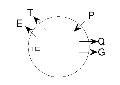
Hydrologic budget that considers surface and ground water
|
- The following budget considers only surface water:
- I = infiltration

Hydrologic budget that considers only surface water
|
- Notice some double counting, because I can return immediately as T and can convert to groundwater and eventually
return as Q.
- For certain applications (flood calculations), when change in storage ΔS is zero, and the sum of
E + T + I can be taken as the losses (to runoff) L, then runoff Q is:
|
1.4 USES OF ENGINEERING HYDROLOGY
|
- Examples:
- Probable maximum flood (PMF) at a damsite, to design spillway.
- Variation of water yield from season to season; and from year to year.
- Relation and quantity of surface water and groundwater (baseflow vs. flood flows).
- Quantity and permanence of low flows (hydropower, water quality, inland navigation).
- Sizing storage reservoirs (multiannual flows).
- Hydrologic hardware (field equipment) and software (computer programs).
- Hydrologists use flow rates (m3/sec) and volumes (m3).
- Volumes are often expressed as units of depth (mm, cm, in) over the catchment area.
|
1.5 APPROACHES TO ENGINEERING HYDROLOGY
|
- Models are either material or formal.
- Material models are physical representations of the prototype.
- Formal model is a mathematical abstraction of an idealized situation.
- Material models are either iconic or analog.
- Iconic models are simplified representations of real systems, such as lysimeters Coshocton OH; San Dimas, CA),
rainfall simulators (Colorado State University),
and experimental watersheds (Walnut Gulch, AZ).
- Analog models use other substances, such as electricity.
- All formal models are mathematical in nature.
- Mathematical models classify into:
- Deterministic: Formulated using physical or chemical laws.
- Probabilistic: Governed by laws of chance.
- Conceptual: Simplified representation of physical process; works in the mean.
- Parametric: Uses algebraic equations and is limited to a certain region.
- Kinematic wave routing is deterministic
(page 277).
- Gumbel method of flood frequency is probabilistic
(page 223).
- Cascade of linear reservoirs (CLR) is conceptual
(page 313);
runoff curve number is conceptual
(page 155);
- USGS State equations for flood determination are parametric
(page 519).
- Rational method (Qp = CIA) is conceptual (IA) and parametric (C)
(page 110).
- Rational method is conceptual because it simulates runoff
concentration; parametric because the runoff coefficients are empirical.
- Hydrologic models can be lumped or distributed.
- Lumped models describe temporal variations but cannot describe spatial variations.
- Distributed models can describe both temporal and spatial variations.
- Quasi-distributed model such as HEC-HMS's Modified Clark is a hybrid: a lumped method in a distributed GIS context.
- Solutions can be analytical or numerical.
- Models used in practice are numerical in nature (example: HEC-HMS, NRCS TR-20).
|
1.6 SURFACE RUNOFF, FLOOD HYDROLOGY, AND CATCHMENT SCALE
|
- Surface runoff occurs when rainfall intensity exceeds the abstractive capability of the catchment.
- It also occurs when the soil profile is saturated.
- Large amounts of surface runoff are referred to as "floods."
- Rainfall varies in space and time.
- Rainfall can be assumed to vary as follows:
- Constant in time and space: Small catchments, the rational method.
- Constant in space but varying in time: Midsize catchments, the unit hydrograph.
- Varying in both space and time: Large catchments, reservoir and channel routing.
- The larger the catchment, the more likely that it is gaged.
- Probabilistic approach is suitable for large catchments, but also for midsize catchments.
- Parametric approach suitable for midsize catchments (USGS State equations).
- The unit hydrograph, a conceptual method, is particularly applicable to midsize catchments.
- Routing can be used for all size catchments, but is required for large catchments (due primarily
to the spatial variability of rainfall).
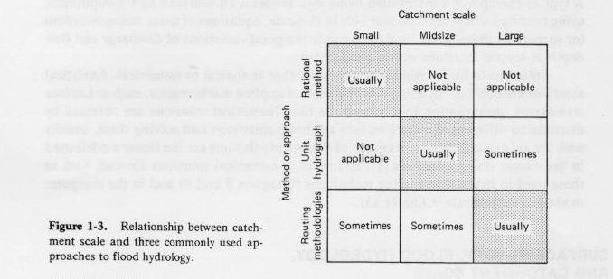
Fig. 1-3
|
- Hydrologic methods vary from country to country.
- Some U.S. methods such as the NRCS runoff curve number are used throughout the world.
|