|
290. CURRENT RESEARCH
[070206]
|
- Web-based engineering practice. The use of web-authoring tools such as
HTML, CSS, PHP, PERL and CGI to practice engineering teaching and research
on the web. Examples are the following websites:
ponce.sdsu.edu
onlinecomp.sdsu.edu
onlinechannel.sdsu.edu
manningsn.sdsu.edu
manningsn2.sdsu.edu
elnino.sdsu.edu
milestones.sdsu.edu
mockus.sdsu.edu
facets.sdsu.edu
commons.sdsu.edu
perpetual.sdsu.edu
alamar.sdsu.edu
calculator.sdsu.edu
calculator2.sdsu.edu
calculator3.sdsu.edu
rational.sdsu.edu
threeissues.sdsu.edu
historicalhydrology.sdsu.edu
campcreek.sdsu.edu
severance.sdsu.edu
chezy.sdsu.edu
ecolatrine.sdsu.edu
globalwarming.sdsu.edu
carsandpeople.sdsu.edu
tierradelsol.sdsu.edu
groundwater.sdsu.edu
-
Groundwater utilization and sustainability.
The indiscriminate and sometimes excessive use of groundwater has led to questions regarding its sustainability. To what extent can groundwater be exploited without unduly compromising the principle of sustainable development? The sustainability of groundwater utilization must be assessed from an interdisciplinary perspective, where hydrology, ecology, geomorphology, and climatology play an important role. Shallow groundwater flow systems should be distinguished from deep groundwater flow systems; the former interact with surface water, while the latter do not. Generally, groundwater does not recycle as fast as the surface water, with rates of groundwater turnover varying from years to millennia, depending on aquifer location, type, depth, properties, and connectivity. Excessive pumping can lead to groundwater depletion, where groundwater is extracted at a rate faster that it can be replenished. Unregulated groundwater use leads to the "Tragedy of the Commons," with the eventual depletion of the resource and ruin to all. The effects of excessive groundwater development tend to become apparent gradually, with time often measured in decades. To assure sustainability, studies must show that the hydrological, ecological, and other impacts of groundwater utilization are minimal. In addition to water quantity, sustainability must imply the preservation of water quality.
-
Feasibility of pumping scheme to provide water for Tecate River Park.
The feasibility of pumping treated effluent to provide water for the Tecate River Park is studied.
A certain amount of recycled water, estimated between 40 and up to 300 L/s,
may be available to benefit the Tecate River Park.
The hydraulic conductivity of the bed material in the Tecate river has been measured in-situ at six sites along the study reach.
The bed material consists of poorly graded sands (SP) and fine sands with silt (SP-SM),
with some exceptions. Tests show that the hydraulic conductivity varies from high to very high.
Channel routing shows that if the hydraulic conductivity of the streambed is very high, the delivered
flows will be abstracted very quickly into the groundwater and very little of it will remain in the surface waters.
On the other hand, if the hydraulic conductivity is high, a substantial fraction of the delivered
flows will remain in the surface water and in the vadose zone, and become available for evapotranspiration.
-
Hydrology and hydraulics for the Tecate Creek corridor restoration.
The study encompasses the reach of Tecate Creek, from its upstream point east of Tecate,
at the Highway 2 bridge with Cañada Joe Bill,
to its downstream point west of Tecate,
at the Highway 2 bridge with Tecate Creek, a total of 11.1 km.
The study will consider the following stream uses:
(1) flood mitigation, (2) groundwater replenishment,
(3) land use, (3) recreation, (4) landscaping, (5) habitat for flora and fauna,
(6) preservation and conservation of the riparian corridor,
(7) improvement of water quality, and
(8) compliance with federal stream zoning restrictions.
The following specific objectives are identified:
(1) a hydrologic study to determine flood discharges, and
(2) a hydraulic study to determine flood conveyance.
-
Sustainable architecture of Arroyo Alamar, Baja California, Mexico.
The study comprises hydrology, hydroecology, architecture, landscape architecture,
geographic information systems, and related socioeconomic aspects.
Sustainable architecture encompasses the spatial design of the 10-km reach of Arroyo Alamar,
seeking a compromise between hydroecological requirements and the proposed uses of the river
and its flood plain.
The hydroecological requirements include groundwater replenishment,
preservation of the riparian corridor, and flood mitigation.
The proposed uses include recreation, landscaping, and aesthetics.
The recreational features include pedestrian walkways, exercise tracks, children playgrounds,
soccer fields, tennis/basketball courts, rollerskating and skateboard parks, and golf courses.
-
Hydroecological characterization of Arroyo Alamar, Baja California, Mexico.
The project will rehabilitate the stream channel of Arroyo Alamar, in Tijuana, Baja California,
to enable a seamless interaction of diverse stream functions and uses, including
flood mitigation, groundwater replenishment, preservation of riparian corridors,
enhancement of water quality, satisfaction of federal
stream zoning restrictions, and multipurpose land use such as agriculture,
light industry, recreation, urban landscaping, and ecotourism.
The characterization will use design flood discharges obtained in a previously
funded project to provide a multi-terraced channel
within a planned environment.
- Three issues of sustainable management
in the Ojos Negros valley, Baja California, Mexico.
The following issues were examined:
(1) The economic and social impact of the coquillo, a weed
which is gradually taking over formerly productive agricultural fields and converting them into wastelands;
(2) The environmental impact of sand and gravel
mining of the arroyos on the water resources of the region; and
(3) The impact of climatic variability on agriculture and animal husbandry, which are the lifeline
economic activities of the valley.
- Dam-breach flood wave propagation using dimensionless parameters.
The theory of linear stability is used to develop
dimensionless parameters to propagate flood waves
caused by dam breaches. At a certain dimensionless distance downstream, the flood stage is
shown to be independent of a specially formulated Froude number based on
breach peak discharge and outflow volume.
- Other research topics.
|
|
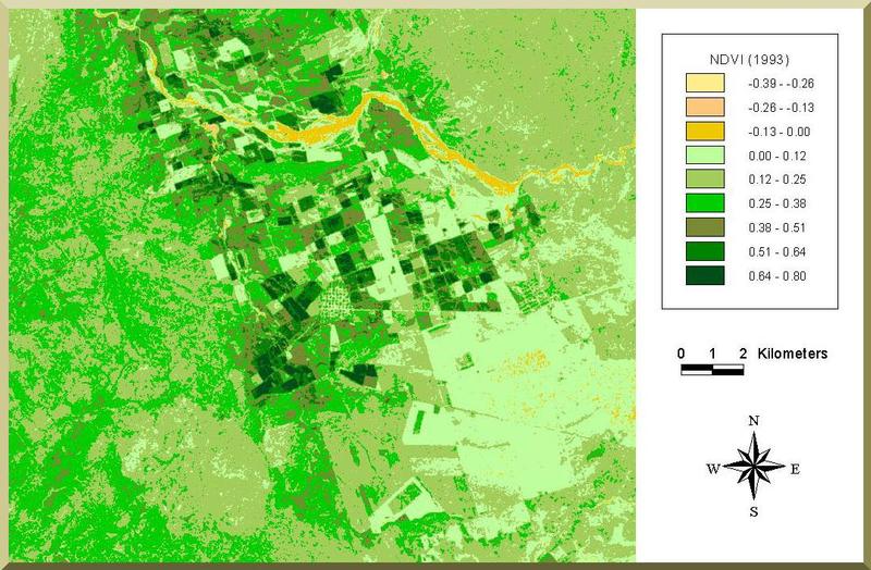
May 1993 NDVI map of the Ojos Negros valley,
in Baja California, showing actively growing crops in green to dark green,
and rock outcropping in brownish yellow to gray. |
|