|
Skip Navigation Links | |||
TIME ENGINEERING:THE SINGULAR CASE OF THE SALTON BASIN
|
|
Abstract. Time Engineering is the engineering that is carried out for the specific purpose of buying or obtaining an indefinite time from Nature. The Salton Basin is a classical case of time engineering. The Salton Basin is a geological depression located in southeastern California (USA) and northeast Baja California, Mexico, and lying partially below sea level. From a geomorphological perspective, the region is endorheic, that is, landlocked. Given the location of the southern end of the basin, in Baja California, immediately west of the mouth of the mighty Colorado River, time had in store a different fate for the region. In geologic time, the Colorado River has deposited sufficient amounts of sediment near its mouth to form a natural barrier, thus effectively separating the Salton Basin from the Gulf of California. The prevailing hydraulic gradients indicate that the river could flow either north, towards the Salton basin, or south, towards the Gulf of California, depending on variations in the flow of water and sediments, and the shape of the promontory, which tends to vary in geologic time.
Until the late 1800s, the portion of the Salton Basin located north of the U.S.-Mexico
border was known as the Colorado Desert. Around the year 1900, this name was changed
to Imperial Valley, in conjunction with the intense agricultural development that
would take place from that date on. With a secure source of water from the Colorado,
the desert turned out to be very fertile, due in part to its mild climate, but also
to its abundant supply of juvenile nutrients. |
1. TIME ENGINEERING
Engineering involves
the design of an artificial system, quite distinct from a natural system,
to perform a function, task, or service to satisfy a perceived societal need.
Engineering uses physical, chemical, and biological
principles to design a certain system,
with the focus on performance.
Time Engineering is defined here as the engineering which has the
specific purpose of buying
time from Nature. Geologic time is Nature's clock;
human time is but a small fraction of it. The Earth was formed about 4,600,000,000 years ago,
yet the entire timespan of
human civilization is estimated at about 10,000 years,
amounting to barely 0.000002, or 0.0002% of geologic
time.
The timeframe of human existence, where a generation typically spans 25 years and
a human life may last an average of three generations, is also small compared to the timespan
of human civilization. The number of human generations in the timespan of
civilization is about 400.
The ratio of timespan of civilization to timespan of an individual's life may be around half this amount,
i.e., 200.
Thus, the time of humans is relatively small compared to the time of history;
in turn, the latter is small compared to all time.
This discussion of time in engineering is relevant
because it is closely linked to the issue of sustainability.
What should be the timeframe of sustainable engineering design? Four generations? Forty generations? Four-hundred generations?
Or, ideally, the maximum possible: Forever? These issues are addressed here with reference to
the case of the Salton Basin, in California.
2. FREQUENCY-BASED DESIGN
The concept of frequency-based design is well established.
Projects are designed
to perform their intended function for a certain number of years,
after which some type of failure is to be expected.
For instance, in hydraulic engineering, the return period of 100 years is normally
regarded as a standard return period for average-sized
regional projects.1
Lower return periods (10 to 25 years)
are usually considered for smaller projects, such as culverts, while higher return periods (500 years)
are applicable to larger projects, such as bridges.
In the case of dams, where failure may lead to loss of life,
return periods up to 10,000 years (and sometimes even larger)
have been considered.2
Frequency-based design differs from time engineering in one important respect:
Frequency-based design sets an arbitrary limit, after which failure is to be expected
on the basis of a statistical/probabilistic analysis.
On the other hand, time engineering ostensibly does not define the time to failure;
instead, it borrows from geologic time an undefined relatively small amount of time
in order to provide an economic value to society.
In hydraulic engineering, time engineering has a distinct geomorphological flavor.
While the timespan of geomorphological
processes is measured in millions of years, that of the human experience
may be at most several thousand years. This timescale difference places at odds
natural laws with the realities of the socioeconomic world.
Natural processes will still take place in due time, but it may
take too long, long enough to be of little consequence to human society.
3. THE CASE OF THE SALTON BASIN
A significant case study of time engineering is that of the Salton Basin, a geologic depression between two parallel faults
(graben)
located in southeastern California and lying partly below sea level.
From a geomorphological perspective, the region is endorheic,
with no outlet to the sea. Millions of years ago,
the entire Salton basin used to be part of the Gulf of California,
which reached northward a distance of about 250 km, ending in the proximity of what is now
the city of Indio, in Riverside county.
Given the location of the basin's southernmost extremity, in Baja California (Mexico),
immediately west of the mouth of the mighty Colorado river,
a different destiny was surely in store for the region.
In geologic time,
the Colorado river deposited enough sediments near its mouth to create a natural barrier,
effectively cutting off the Salton Basin from the Gulf of California.4
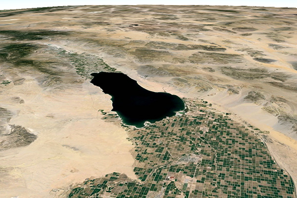
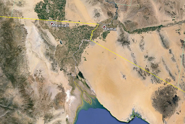
Fig. 1 Delta of the Colorado river, west of Yuma, Arizona,
and south of Mexicali, Mexico.
The prevailing hydraulic gradients dictate that
the Colorado river could flow either north, toward the Salton Basin,
or south, toward the Gulf of California, depending on the vagaries of the flow of water and sediments
and the consequent shape of the mound, which tends to vary in geologic time
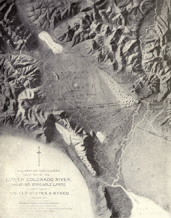
Fig. 2 Legacy relief map of the delta of the Lower
Colorado river.
Towards the end of the 19th century, the portion of the
Salton Basin north of the U.S.-Mexico border was
known as the Colorado Desert.
At about the year 1900, its name was changed to Imperial Valley, setting the stage for the intense
agricultural development that ensued. However,
due to the enormeous quantities of sediment
being transported by the Colorado river, management of the river for
irrigation development proved to be a challenge (Fig. 3).
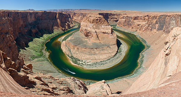
Fig. 3 The
Colorado River at Horseshoe Bend, Arizona.
History shows that in 1905 the Colorado river tried once again to reclaim
Lake Cahuilla.7
A fight ensued and a concerted effort led by E. H. Harriman, of the Southern Pacific Railroad Company,
resulted in the triumph of the will of man, with the
Colorado being routed south against its own design.8
The success in harnessing the Colorado river contributed to
the development of the Imperial and Mexicali valleys, on each side of the U.S.-Mexico border,
with the attendant economic benefits to society.
With a secure source of water from the Colorado
assured, the desert proved to be very productive,
due in part to its mild climate, but also to its plentiful store of fresh nutrients.
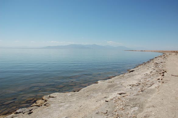
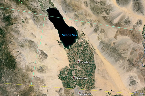
Fig. 4 Aerial view of the Salton Sea,
with the Imperial valley to the SSE.
4. CLOSING REMARKS
Will the Colorado river again attempt to flood the Salton basin in the future?
The answer to this question is: Probably. Much less certain is the timeframe
of the probable occurrence. In typical geomorphological character,
the associated return period would be anybody's guess. In the meantime, life,
in most of its manifestations,
continues to thrive in the Salton Basin.10
A related question is the following: In view of the inherent hydrological risk,
should the Salton Basin
have been developed at all? The answer has socioeconomic and political
implications: Yes, as long as the risks are recognized and noted for the future.
In practice, the chances are slim that we may ever get to experience the event.11 Thus, in the realm of
Fig. 5 The Salton Sea at Bombay Beach, California.
ENDNOTES
1
2
The ERP Report: What Went Wrong and Why?" Civil Engineering, 77(6), June 2007, 54-61, 73-76.
3 Ponce, V. M.
Engineering Hydrology: Principles and Practices, Second edition, online.
4 The Colorado River
was originally named Rio Colorado or "Red River" by the early Spanish settlers.
The reddish-brown color that gave the river its
name became a rarity upon completion of Glen Canyon Dam in 1963. The silt and sediments
are now trapped behind the dam at the bottom of Lake Powell.
5
Closer examination reveals that a connection between the Salton Basin and the Gulf of California
is effectively established through the Rio Hardy, in Baja California, Mexico, at an elevation of about
6 The archaeologist Malcolm J. Rogers has
examined aboriginal pottery left
on shoreline sites and concluded that the lake had been present
between about 1000 and 1500 A.D.
Subsequent studies have established that there were not
one but several high stands of the lake, before 1000 and after 1500 A.D.,
including a stand in the seventeenth century,
when Spanish explorers had already reached the Lower
Colorado River (Wikipedia, Salton Sea).
7 See short article with contemporary photos in
Cutback in the New river near Calexico.
8 Kennan, G. 1917.
The Salton Sea:
An account of Harriman's fight with the Colorado river. 147 p.
9 Ponce, V. M. 2005.
The Salton Sea: An Assessment.
10
The current salinity of the Salton Sea is about 60,000 ppm,
which is about 70% greater than the ocean (Wikipedia).
Its salinity has been increasing at the rate of about 500 ppm per year; thus,
eventually the fish will disappear.
A new ecosystem will take over,
consisting of brine shrimp (Artemia franciscana) and other hypersaline species.
11 Before construction of Glen Canyon Dam, in Utah,
and Hoover Dam, which straddles Arizona and Nevada,
the Colorado river had been known to reach peak flow rates of 250,000 cfs (7,100 m3/s) and, therefore, to carry large quantities of sediment.
As long as these two dams continue to attenuate the peak flows, it is not likely that the Colorado river
will return to the historic high peak flows.
Google Earth®
[Click on the figure to enlarge]
U.S. Reclamation Service and U.S. Geological Survey
Christian Mehlführer (Creative Commons)
Google Earth®