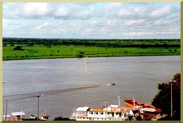
| The Farolete Balduíno, near the port of Ladario, Mato Grosso do Sul. |
THE UPPER PARAGUAY RIVER AND PANTANAL OF MATO GROSSO
| The Farolete Balduíno, near the port of Ladario, Mato Grosso do Sul. |
|
This section describes the physiographic and hydrologic characteristics of the Upper Paraguay River and the adjoining Pantanal of Mato Grosso. It is divided into four subsections:
The information of this section serves as the basis for the analysis of Section 4. The references are listed in Appendix 1. The figures and tables are included in Appendices 2 and 3, respectively.
3.1 Geological SettingThe geology of the Upper Paraguay river and environs is described in Almeida (1945), Projeto Bodoquena (1979), Projecto RADAMBRASIL (1982a&b), and Godoi Filho (1986), among others. The predominantly Upper Precambrian formations underlie extensive Quaternary deposits, but with significant rock outcrops. Geomorphologic evidence reveals the presence of substantial tectonic activity in the form of subsidence and uplift (Freitas, 1951; DNOS, 1974; Orellana, 1979; Ab'Sáber, 1988). Table 5 shows the stratigraphic units that are present in the Upper Paraguay river. The Upper Precambrian is represented by the groups Alto Paraguay, Corumbá, and Jacadigo, and their respective formations; the Paleozoic by the Coimbra formation; the Mesozoic by the Alkaline Fecho dos Morros formation; and the Cenozoic by the Xaraiés and Pantanal formations. Table 6 lists primary rock types, including sandstones, silt stones, limestones, conglomerates, dolomites, calcareous dolomites, syenites, trachytes, calcareous tufa, and travertines. Table 7 shows the general location of rock outcrops in the vicinity of the Upper Paraguay river. Navigation charts confirm the existence of numerous rock outcrops on or along the Upper Paraguay river (Marinha do Brasil, 1974; and later dates). A list of these outcrops is shown in Table 8, and their possible rock types in Table 9. Significantly, four of these outcrops are located in the middle of the channel (Passo Simăo Nunes Inferior, Córrego Bonfim, Farolete Balduíno, and Passo Mucună), effectively functioning as grade controls. The existence of rock outcrops have been recognized for more than a century (Leverger, 1862a&b). Some of them have been documented in the Internave report (INTERNAVE, 1990). These facts confirm that the Upper Paraguay river is substantially controlled by the prevailing geology. While the Quaternary sediments of the Pantanal formation are the most obvious surficial feature of the landscape, the longitudinal slope of the river is controlled more by the rock outcrops than by the alluvium. As shown in Table 8, there are thirty-two (32) rock outcrops within 1270 km of river, an average of one every 40 km. Other outcrops along the river, particularly that of canga, may have been less thoroughly documented. According to Dorr (1945), canga is colluvium or talus, composed in large part of fragments of iron-rich rock, which has been recemented into a coherent mass by limonite. In the vicinity of the Morro de Urucum, these outcrops tend to have a linear distribution, suggesting the possibility of a fault (Dorr, 1945; Almeida, 1945). Moreover, it is noted that the Internave report mentions the occurrence of canga in several places along the river, including Porto Rabicho (km 2740), entrance to Passo do Conselho (km 2607), and upstream of Passo Piuva Inferior (km 2573) (INTERNAVE, 1990). Table 10 describes three geologic faults in the vicinity of the Upper Paraguay river (Projeto RADAMBRASIL, 1982a). The Falha da Lagoa, which crosses Lagoa Gaíba (Section 3.3.1), may have a significant effect on the flow of the Upper Paraguay river. Likewise, the Falha da Penha, which also crosses Lagoa Gaíba, is strategically located in close proximity to the river (Fig. 5). According to DNOS (1974), it appears that the northern portion of the Pantanal has subsided in relation to the Serra do Amolar (Section 3.2). This would explain the elevated position of the older rocks in the Serra do Amolar. The tectonic character of the Upper Paraguay river basin has been admirably described by Freitas (1951). Orellana (1979) has stated that active faults in a direction contrary to the regional runoff have created local sills (soleiras) that act to impede runoff. More recently, Ab'Sáber (1988) has attributed the genesis of the Pantanal to "a tectonic character dominated by a system of faults which are geomorphologically contrary..." A historical note regarding rock outcrops in the Upper Paraguay: In describing his passage through Lagoa Gaíba almost 150 years ago (1846), Captain Augusto Leverger of the Brazilian Navy cautioned against the rocky sills which protrude onto the lake as follows (Leverger, 1862a, p. 317):
|
| "...Virando a Norte, tive de circumdar um como promontorio da margem do poente da lagoa o qual é terminado por um cabeço pedregoso e coberto de mato, ao cual devese dar resguardo a fim de evitar as muitas pedras que o cercam, umas submergidas, outras a flor de agua ou pouco elevadas..." |
|
3.2 Geomorphological SettingThe geomorphology of the Upper Paraguay river basin is described in Projecto RADAMBRASIL (1982a&b) and Silva (1986). The geomorphic units in the vicinity of the Upper Paraguay river are:
The Serras of Urucum-Amolar comprise two groups of serras (residual hills or mountain ranges) located to the right (west) of the Upper Paraguay river, close to the Bolivian border. These serras are important because of their strategic location, on the right bank, and often next to the river. The Serra do Urucum, southeast of Corumbá, comprises the morrarias (group of residual hills) of Urucum, Santa Cruz, Săo Domingos, Grande, Rabichăo, and Tromba dos Macacos; further south, about 40-50 km, are the morrarias of Zanetti, Albuquerque, Mato Grande, Saiută, and Pelada. The Serra do Amolar, about 60-160 km north of Corumbá, comprises the Serra do Amolar proper and the morrarias of Ínsua, Novos Dourados, Santa Tereza, Castelo, and others of smaller size. The elevation of these mountains varies from 300 to 900 m, the highest point being at Morro Grande (1065 m). The contact between the Serra of Urucum-Amolar and adjacent geomorphic units is often sudden, revealing the presence of faults of probable Cenozoic age (Projeto RADAMBRASIL, 1982a). The Serrana Province consists of a group of serras of roughly parallel crest alignment, located east of Cáceres, trending in a predominantly SW-NE direction. From SW to NE, these serras are: (1) Simăo Nunes, (2) Colonia, (3) Acorizal, (4) Facăo, (5) Primavera, (6) Ponta do Morro, (7) Quilombo, (8) Morro Grande, (9) Jacobina, (10) Barreiro Preto, (11) Chapola, (12) Boi Morto, (13) Bocainăo, (14) Campina, and (15) Retiro (Projeto RADAMBRASIL, 1982a). The Serra Simăo Nunes, the most southwestern of the group, comes in direct contact with the Upper Paraguay river in several locations along 45 km of river, on the left bank, from Passo Acuri, at Km 2128 (Km 3368 of the Hidrovia), to Passo Morro Pelado, at Km 2083 (Km 3323 of the Hidrovia) (Table 20). The elevations in the Serrana Province vary from 300 to 700 m. The rock formations are those of the Alto Paraguay group (Table 5). The Depression of the Paraguay River comprises extensive plain surfaces which surround the Serrana province, and to a lesser extent, the Serra of Urucum-Amolar. The relief is mild, slightly undular, with elevations varying between 150 to 250 m, and has underlying Precambrian and Cambrian formations, which often outcrop through the Quaternary deposits. The Plains and Swamps of Mato Grosso (Planícies e Pantanais Matogrossenses) resemble an amphitheater of roughly semicircular shape, with its approximate center at Corumbá, comprising 28 percent of the Upper Paraguay river basin (Fig. 2). The plains are a series of mutually coalescing alluvial fans, surrounded by the Depression of the Paraguay River almost continuously to the east, and discontinuously to the north and south. They comprise an extensive surface of accumulation, of extremely flat relief, with elevations varying from 80 to 150 m, and subject to seasonal flooding by the Upper Paraguay river and its tributaries. Valley slopes are about an order of magnitude greater along the tributaries than along the main channel. The tributaries cross the plains in a predominantly east-west direction, with a slight orientation towards the center of the amphiteather, with valley slopes of 12 to 50 cm/km. The high sediment production of the tributaries has forced the main channel of the Upper Paraguay, which runs predominantly from north to south, to closely parallel the western edge of the plains (Schumm, 1977). Moreover, its unusually mild slope (0.7-6.5 cm/km) causes it to regularly overflow its banks during the wet season. Sánchez (1978) has identified ten geomorphic subunits within the plains and swamps of Mato Grosso (Table 11). The Pantanal is seen to be a complex mosaic of geomorphic features or subunits, with a regional base level at the Upper Paraguay river, along the western edge of the plains. In turn, the base level of the Upper Paraguay river is at its mouth, at the confluence with the Apa river. The sequence of events leading to the formation of the Pantanal is described by Projeto Bodoquena (1979) and Ab'Sáber (1988). During the Jurassic period, the prevailing arid climate led to substantial sediment deposition, mostly in the form of sand dunes. The Cretaceous period that followed saw a change to a more humid climate, which transformed the desert into a flood plain with numerous lakes and swamps. The end of the Mesozoic era signaled the end of sedimentation and the beginning of slow epeirogenic movements, which were generally upwards. The subsidence of the Pantanal occurred later, probably in the Pleistocene (Tricart, 1982). A clear evidence of subsidence is the great depth of the Quaternary deposits, which at Fazenda Piquiri reaches beyond 320 m, and at Fazenda Săo Bento, beyond 420 m (320 m below sea level). The maximum depth of the Pantanal sediments has been estimated at 500 m at the Pantanal's center, on the alluvial fan of the Taquari river (Godoi Filho, 1986). Tectonic uplift to the south strangled the exit of the depression. In the last 6 million years, under the effects of subsidence and uplift, the Upper Paraguay river has been forced to carve an exit through the basal rocks to the south, a situation which explains its unusually mild slopes.
3.3 Hydrological SettingThe hydrology of the Upper Paraguay river is described in DNOS (1974) and EDIBAP (1979). The Upper Paraguay river flows from its headwaters in the Serra de Tapirapuă, in Mato Grosso, to its mouth at the confluence with the Apa river, in Mato Grosso do Sul. At Cáceres, where it meets the first human settlement of importance, the river drains an area of 33 860 km2; at the Apa river confluence, downstream of Porto Murtinho, it drains an area of 496 000 km2. The distance along the river, from Cáceres to the Apa river confluence is 1270 km. Throughout most of this distance, the Upper Paraguay river crosses the Pantanal of Mato Grosso, flooding the Pantanal typically from March to August, and draining it from September to February. Thus, the hydrology of the Upper Paraguay river is effectively connected to and interdependent with that of the Pantanal. This blurs the distinction between surface water and groundwater, significantly increasing the complexity of hydrologic analysis. In fact, the peculiar geologic and geomorphologic setting of the Upper Paraguay river and the adjoining Pantanal results in a unique hydrologic behavior, unmatched in the American continent. The prevailing climate is dry subhumid, grading to wet subhumid along a narrow strip paralleling the mountain ranges that delimit the basin to the north, east, and south, and humid in limited northernmost areas bordering with the Amazon basin (EDIBAP, 1979). The spatially averaged, mean annual rainfall in the Upper Paraguay basin ranges from 1180 mm (Projeto RADAMBRASIL, 1984) to 1380 mm (EDIBAP, 1979), depending on the data source. This fact alone would dictate that the mean runoff coefficient (the ratio of mean annual runoff to mean annual rainfall) should be relatively high, perhaps somewhat less than the global average, estimated at 0.39 for peripheral continental areas by L'vovich (1979) or 0.46 by Berner and Berner (1987). Instead, the mean runoff coefficient of the Upper Paraguay is quite low, varying in the range 0.07-0.10, depending on which data is used in the calculation (Section 3.3.4). The abnormally low runoff coefficient of the Upper Paraguay river is a direct result of its hydrologic interaction with the Pantanal. The latter functions as an immense surface/subsurface reservoir which stores water annually and multiannually. In the annual time frame, the Pantanal stores water during the wet season and releases it back to the main channel during the subsequent dry season. In the multiannual timeframe, the Pantanal stores water in a wet year and releases it back to the main channel in a dry year. In this process, the slowness of which is compounded by the unusually mild relief, large amounts of would-be runoff are instead returned to the atmosphere through evaporation and evapotranspiration. The latter helps to sustain a series of closely related ecosystems, characteristically marshes or wetlands, their biotic productivity closely linked to the annual flood pulse (Junk et al, 1989).
3.3.1 HydrographyThe hydrography of the Upper Paraguay river, from Cáceres to the Apa river confluence, is shown in schematic form in Fig. 6. At Cáceres, the Paraguay river has already received the contributions of two of its most important right-bank tributaries: Sepotuba and Cabaçal. From Cáceres, the river flows south towards Descalvados, a distance of 139 km along the river. At a point 71 km downstream of Cáceres, the Paraguay receives the contribution of its third important right-bank tributary, the Jauru. From Descalvados, the river flows first southeast and then turns south towards Porto Conceiçăo, a distance of 121 km. At a point 46 km downstream of Descalvados, the river branches into two channels: the Paraguay proper (to the right) and the Bracinho (to the left). This bifurcation marks the beginning of the Pantanal proper; from this point on, as far downstream as Amolar, the Paraguay river crosses extensive areas of lakes (baías or lagoas) and adjoining permanently flooded plains. The two branches delimit the island of Taiamă, and rejoin 43 km downstream, measured along the main channel. From Porto Conceiçăo, the river first flows south and then turns southwest towards (Fazenda) Bela Vista do Norte, a distance of 135 km. At a point 40 km downstream of Porto Conceiçăo, the river again branches into two channels: the Paraguay proper (to the right) and the Caracará (to the left). The two branches form the great island of Caracará and rejoin further south, near Refúgio das Tręs Bocas. The main channel of the Paraguay flows southwest towards Bela Vista do Norte, at the base of Morraria da Ínsua (Fig. 7). The Caracará branch flows south towards Refúgio das Tręs Bocas, in the vicinity of the Serra do Amolar. The island of Caracará constitutes a veritable inland delta, with its apex at the bifurcation (40 km downstream of Porto Conceiçăo), and its base the Paraguay river itself, which turns from Bela Vista do Norte southeast to Refúgio das Tręs Bocas, flowing for a distance of 53 km. During extraordinary and exceptional floods, most of the island of Caracará is completely submerged. In the vicinity of the Morraria da Ínsua and the Serra do Amolar, the Paraguay river interacts with three large lakes: Uberaba, Gaíba, and Mandioré (Figs. 3 and 6). The larger of the three, Lagoa Uberaba, located north of Morraria da Ínsua, receives over flows from the Paraguay as well as runoff from local streams and from Corixa Grande, the last significant right-bank tributary of the Paraguay. Lagoa Gaíba is located between Morraria da Ínsua and Serra do Amolar. It consists of three smaller lakes:
The link between the Upper Paraguay river and Lagoa Gaíba is the Riacho da Gaíba. However, a branch of the Paraguay drains into Pre-Gaíba. The Riacho da Gaíba is generally as deep as the Paraguay, excluding the exit of Lagoa Gaíba, where it is extremely shallow, with a depth of 0.1-0.6 m and a width of 2000 m (DNOS, 1974). Judging by the unmixed colors of its waters, the Riacho da Gaíba appears to drain Lagoa Gaíba to the right (reddish color, iron-rich dissolved solids), Lagoa Uberaba to the center (dark color, humic colloids), and the main channel of the Paraguay river to the left (light brown color, suspended sediments) (Fig. 7). The link between Lagoa Gaíba and Lagoa Uberaba is the Canal Pedro II, with a length of about 100 km. The direction of the current in the Canal Pedro II is normally from Lagoa Uberaba to Gaíba, but it can change seasonally if the flow is considerably reduced (DNOS, 1974). From Refúgio das Tręs Bocas, the river flows south towards Amolar, a distance of 28 km. Shortly before reaching Refúgio das Tręs Bocas, the river branches into two channels: the Paraguay to the left, and the Moquém to the right. Before rejoining the Paraguay, the Moquém river branches into the Ingazal, which joins together with the Săo Jorge, another branch of the Paraguay. In turn, the Săo Jorge rejoins the Paraguay immediately upstream of Amolar. These bifurcations reveal the extremely small gradient in this section of the Paraguay river. From Amolar, the river flows south towards Porto Săo Francisco, a distance of 58 km. At a point 46 km downstream of Amolar, the river flows past Riacho da Mandioré, the inlet to Lagoa Mandioré. The Paraguay river flows into Lagoa Mandioré during high flows, and out during low flows. From Porto Săo Francisco, the river flows in a general southwestern direction towards Corumbá, a distance of 146 km, and then turns east to Ladario, a distance of 7 km from Corumbá. At a point 16 km downstream of Porto Săo Francisco, the Paraguay river branches again into two channels, the Paraguay to the right, and the Paraguai-Mirim to the left. The latter crosses the eastern plains and rejoins the Paraguay river 20 km downstream of Ladario. Between Porto Săo Francisco and Corumbá, the river can overflow (to the right) into the Lagoa Conceiçăo, Lagoa do Castelo, and Lagoa Cáceres. The connection between Lagoa Cáceres, in Bolivia, and the Paraguay river is the Canal Tamengo, with its mouth in the vicinity of Corumbá. From Ladario, the river flows first east and then southeast to Porto da Manga, a distance of 69 km. At a point 32 km downstream of Ladario, the Paraguay river receives the contribution of the Taquari Velho (an ancient channel of the Taquari river) to the left. About 2 km upstream of Porto da Manga, the Paraguay river receives the contribution of the Taquari river to the left. The Negro river, a tributary of the Taquari, flows into the latter right upstream of its confluence with the Paraguay. From Porto da Manga, the river flows southwest to Porto Esperança, a distance of 58 km. At a point 24 km downstream of Porto da Manga, the Paraguay river receives the contribution of the Miranda river. Together with the Aquidauana river, its principal tributary, the Miranda river drains extensive areas of Pantanal and Upper Paraguay river basin to the southeast. From Porto Esperança, the river continues to flow southwest to Forte Coimbra, a distance of 67 km. Between 2 and 40 km downstream of Porto Esperança, the Paraguay river overflows to the left during floods to feed its branch, the Nabileque. The latter crosses the plains east of the Paraguay river in a general southern direction for about 250 km, eventually rejoining the Paraguay river at a point located 217 km downstream of Forte Coimbra. From Forte Coimbra, the river flows in a general southern direction for 239 km towards Barranco Branco; then an additional 51 km to Fecho dos Morros, and from there, 36 km to Porto Murtinho. From Forte Coimbra to Porto Murtinho, the Paraguay river receives the contribution of several left-bank tributaries, including the Aquidabă, Branco, Tereré, and Amonguijá rivers (Fig 2), as well as small surface contributions from the Paraguayan Chaco on the right bank. At Fecho dos Morros (Closing of the Hills), 36 km upstream of Porto Murtinho, the Paraguay river passes through a group of hills, which effectively constitutes a grade control. This control has been referred to as a syenite sill (DNOS, 1974). From Porto Murtinho, the Upper Paraguay river flows south for another 63 km to reach its mouth at the confluence with the Apa river. Table 12 shows selected hydrologic data at gaging stations along the Upper Paraguay river: drainage area, channel length, channel slope, and mean annual discharge. The following observations are made:
The average channel slope along the Upper Paraguay river, from Cáceres to Porto Murtinho, is 3.2 cm/km. As shown in Table 12, the channel slope varies between 0.83 cm/km (Fecho dos Morros-Porto Murtinho) to 6.54 cm/km (Cáceres-Descalvados), and the bed profile alternates between convex and concave. According to principles of fluvial geomorphology, a river that is free to move its bed eventually carves a concave upwards bed profile (Leopold et al, 1964; Leopold, 1994; Christofolleti, 1980). Thus, the documented convexities in bed elevation of the Upper Paraguay river reveal the presence of substantial geologic controls. These controls are operating in at least three reaches:
The extent of the geologic control can be assessed by calculating the size of the hump at locations where its presence is suspected. For instance, from Table 12, the average channel slope from Refúgio das Tręs Bocas to Porto Săo Francisco can be calculated to be 3.51 cm/km. Therefore, a measure of the hump at Amolar is:
Likewise, the average channel slope from Ladario to Porto Esperança is 2.70 cm/km. Therefore, a measure of the hump at Porto da Manga is:
The extent to which these humps can cause backwater in these channels of extremely mild slope is evaluated in Section 4.1.1. A similar calculation at Porto Murtinho is not possible because of lack of data at the river's mouth. However, the downstream river (i.e., the Middle Paraguay) has an average slope of 6 cm/km throughout its 797-km length (Anderson et al, 1993). This much larger downstream slope points to the presence of a substantial geologic control upstream, at Fecho dos Morros, near the mouth of the Upper Paraguay river (Fig. 3). Significantly, this is precisely the location of the syenite sill mentioned by DNOS (1974).
3.3.2 Flood HydrologyThe flood regime of the Upper Paraguay river is a result of complex climatic interactions at the various atmospheric spatial scales. The climate is determined primarily by the basin's geographic location (latitude and continental location) and secondarily by its topographic relief and surface features. Mean annual rainfall varies from as high as 1800 mm at Chapada dos Parecis, the northernmost part of the basin, to as low as 800 mm in the alluvial fan of the Taquari river, near the basin's center (Projeto RADAMBRASIL, 1984). Within these limits, mean annual rainfall increases toward the mountains and high plains (planaltos) in the basin perimeter and decreases toward the alluvial plains at the basin center. Rainfall is concentrated in the summer months. The wettest three-month period is December-February; the driest is June-August. The temporal distribution of rainfall has a tendency to vary spatially in a general north-south direction. The percentage of annual rainfall in the wettest three-month period is greatest in the north (48 percent at Cáceres), gradually decreasing toward the south (to 36 percent at Porto Murtinho). Thus, the northern portion of the basin is prone to flooding from tributary streams. On the other hand, the percentage of annual rainfall in the driest three-month period is smaller in the north (3 percent at Cáceres), gradually increasing toward the south (8 percent at Corumbá, and 12 percent at Porto Murtinho) (EDIBAP, 1979). This indicates the possibility of local droughts recurring on an annual basis. In any stream, the number of flood peaks per year is a good indication of the extent to which surface runoff is being diffused (i.e., attenuated) by the prevailing geomorphic conditions. If the number of flood peaks per year is high, say more than 10, there is little runoff diffusion. Conversely, if there is only one flood peak, runoff diffusion is at its maximum. The Upper Paraguay tributaries have a number of flood peaks, following intense storms that cover all or portions of their respective drainage basins. For instance, the Cuiabá river at Cuiabá has 15 flood peaks per year on the average; the Taquari river at Coxim has 18 flood peaks; the Miranda river at Miranda has 12 flood peaks (DNOS, 1974). A sequence of several flood peaks depicts the local nature of the floods as well as the absence of significant attenuation (the channel gradient varies from 7 to 50 cm/km, Table 3). Unlike its tributaries, the Upper Paraguay river behaves quite differently with respect to the number of flood peaks. This reflects both its milder gradient (0.7 to 6.5 cm/km) and the presence of the Pantanal, which stores and further attenuates the flood peak. The overall effect of this hydrologic process is a reduction in the number of flood peaks. At Cáceres, close to the entrance to the Pantanal, there is an average of five flood peaks per year. However, the number of flood peaks decreases markedly down stream, to one at Amolar, one at Ladario, and one to two from Porto da Manga to Forte Coimbra. Downstream of Forte Coimbra, the number of peaks in creases somewhat due to local contributions. However, the locally generated peaks tend to be much smaller than the peak propagated from upstream (Hydrotechnic Corporation, 1979). The floods in the Upper Paraguay river have been classified as follows (DNOS, 1974; Carvalho, 1986):
The hydrographic records at Ladario (1900-95) show the strong attenuating capacity of the Pantanal upstream of this point. Throughout the 96-yr period of record, the flood wave at Ladario has always had a 12-month duration, i.e., one rise and one recession per year. The rise begins usually in December and finishes in June; the recession begins in June and finishes in December. The occurrence of the flood peak at Ladario varies with the flood level; it is accelerated (to May or April) during extraordinary and exceptional floods, slowed down (to June or July) during a typical flood year (common or mean flood), and again accelerated (to April, and in rare cases, late March) during multiannual droughts. The latter behavior is due to the drought flow being mostly contained within the river banks (Section 4.1.1). Prediction of flood flows along the Upper Paraguay river using mathematical model ing has been attempted by DNOS (1974) and EDIBAP (1979). Under a limited budget, the DNOS model continues to be operated to this date by the Companhia de Pesquisas de Recursos Minerais (CPRM), in Rio de Janeiro. It is a difficult undertaking because of the temporal and spatial variability and complexity of the hydrologic processes, which includes high channel sinuosity, branching, overflows, endorheic surface drainage, and the presence of aquatic macrophytes in the surface waters. This is compounded by the complex nature of the interaction between surface and subsurface water, since the Pantanal has a net gain of water in a wet year, and a net loss in a dry year (EDIBAP, 1979; Adámoli, 1986). The speed of propagation of the annual flood wave can be readily extracted from the discharge measurements. Thus, it has been established that a typical flood wave takes about 130-150 days to travel from Cáceres to Porto Murtinho. This represents an average speed of propagation of only 0.09-0.11 m/s. This extremely low value is due to the substantial contribution of channel overflows to the overall flood wave propagation. Table 15 shows low flow, mean annual, and peak flood discharges along the Upper Paraguay river. Also shown are the ratio of peak flood to low flow discharge, and peak flood to mean annual discharge. The low values of these ratios (compared to other rivers in similar climatic settings) show that the Upper Paraguay river is very effective in decreasing the flood peaks, and correspondingly increasing the low flows. This is due to the presence of the Pantanal. Thus, the Pantanal is the geomorphic feature that provides the mechanism for the spreading (i.e., attenuation, diffusion) of flood flows and, consequently, the increased permanence of low flows.
3.3.3 Low Flows and DroughtsTable 14 shows the minimum seasonal water surface elevation at Ladario, from 1900 to 1994. The following conclusions can be drawn from these records:
As shown by the Ladario gage records, the Upper Paraguay river has a tendency toward multiannual droughts with a recurrence period of 28-30 years. The lack of more extensive data precludes a more thorough analysis. Nevertheless, the tendency is borne out by the data and should be acknowledged. According to the EDIBAP study, the Ladario records, from 1900 through 1977, show a tendency for a decrease in both maximum and minimum seasonal flows (EDIBAP, 1979). In light of the wet period being experienced since 1974, this conclusion is in need of revision.
3.3.4 Basin YieldThe complexity of the hydrologic setting in the Upper Paraguay river precludes a detailed analysis of basin yield vs annual precipitation. However, an approximate analysis based on mean annual precipitation is possible. During a wet year, the annual precipitation P is split in three ways:
Deep percolation is usually small or intractable, and can be neglected on practical grounds (L'vovich, 1979). Conversely, during a dry year, annual precipitation plus (a fraction of) basin storage gointo runoff and vaporization. A simple water balance equation can be formulated as follows: P = R + V ± DS (Eq. 3.1) where DS is positive during a wet year and negative during a dry year (Adámoli, 1986a). In an average year, where change in basin storage is reduced to a minimum, the above equation reduces to: P = R + V (Eq. 3.2) from which average basin yield can be calculated. The spatially averaged mean annual rainfall in the Upper Paraguay basin is 1380 mm according to EDIBAP (1979), or 1180 mm according to RADAMBRASIL (1984). This estimate is based on isohyetal maps prepared for the Brazilian portion of the basin (71 percent). Comparable maps for the remainder of the basin, the portion which is in Eastern Bolivia and Northwestern Paraguay, are not readily available.
The mean annual discharge at the basin mouth (see Table 12) is 1565 m3/s.
According to DNOS (1974), the mean of six years of annual discharge measurements
(1965-71) at Porto Murtinho is 1212 m3/s.
However, this value appears too low, since this
was a particularly dry period (see Section 3.3.3). A longer and wetter period (1969-78)
of measurement at Porto Murtinho (33 discharge measurements) gives 2188 m3/s
(Hidrologia S. A., unpublished data). The basin drainage area at its mouth is 496 000
km2 (Section 2.2). Given this information, the mean annual runoff coefficient
Kr, i.e.,
the ratio of runoff to rainfall, can be calculated as follows: Kr = _____________________________________________________________________________ = 0.072 (1 380 mm/y) (496 000 km2) (1 000 m/km)2 (Eq. 3.3)
A similar calculation, assuming an intermediate value of mean annual discharge
Qa = 1700 m3/s, with P = 1180 mm/y leads to: Kr = _____________________________________________________________________________ = 0.091 (1 180 mm/y) (496 000 km2) (1 000 m/km)2 (Eq. 3.4) Thus, the mean annual runoff coefficient for the Upper Paraguay basin can be taken as Kr = 0.08. This value is interpreted to mean that on an average year, runoff at the basin outlet amounts to eight percent of rainfall, with the balance returned to the atmosphere as evaporation and evapotranspiration (i.e., the vaporization coefficient is Kv = 0.92). A similar analysis for the 11-year period 1965-76 showed a runoff coefficient varying in the range 7-14 percent, with a mean of 10 percent (EDIBAP, 1979). The above calculation confirms that the Pantanal functions not only as an attenuating mechanism for flood flows (and consequent increases in low flows), but also as an abstracting mechanism for all flows, i.e., as an effective means of storing the would-be runoff and converting it instead into evaporation/evapotranspiration. Throughout millennia, this process has been responsible for sustaining the extraordinary biotic potential of the Pantanal (Tricart, 1982). By way of comparison, the mean annual runoff at Cáceres, at the northern entrance to the Pantanal, is 382 m3/s, and the contributing drainage area is 33 860 km2 (Table 12). The mean annual precipitation of the subbasin varies from 2000 mm at the head waters to 1300 mm at Cáceres (EDIBAP, 1979). This amounts to a runoff coefficient Kr= 0.22, which is 2.75 times that of the Upper Paraguay river at its mouth. Likewise, the mean annual runoff coefficient of the Paraná river at Corrientes (Argentina) has been calculated at Kr = 0.16 for the decade 1962-71, Kr = 0.19 for 1972-81, and Kr = 0.22 for 1982-91 (Ponce, 1994). These values are from 2 to 2.75 times that of the Upper Paraguay river at its mouth. These calculations confirm that the markedly strong attenuating and abstracting property of the Upper Paraguay is due to the presence of the Pantanal, while the mean annual runoff coefficients of the Upper Paraguay river at Cáceres (immediately upstream of the Pantanal) and the Paraná river at Corrientes (964 km downstream of the Pantanal) depict more typical subhumid/humid basins. The annual potential evapotranspiration in the Pantanal varies spatially from less than 1100 mm to more than 1400 mm, according to the Thornthwaite method (Alfonsi and Camargo, 1986). Measured pan evaporation data at Fazenda Săo Joăo and Fazenda Rio Negro for 1971-72 shows 1650 mm (Tarifa, 1986). The actual evapotranspiration in an average year is estimated to be: Ea = 0.92 X 1180 mm = 1086 mm, or (Eq. 3.5) Ea = 0.92 X 1380 mm = 1270 mm, (Eq. 3.6) depending on which value of mean annual precipitation is used in the calculation (Projeto RADAMBRASIL, 1984; or EDIBAP, 1979). Thus, on an annual basis, actual evapotranspiration in the Upper Paraguay basin is very close to potential evapotranspiration. The calculation of runoff coefficient is based on surface runoff at the basin outlet, and does not include subsurface runoff at the basin outlet, which may be real but difficult to evaluate directly. The existence of a certain amount of subsurface runoff is postulated on the basis that the mean annual discharge at Asunción, on the Middle Paraguay, 542 km downstream of the Apa river confluence, is 2700 m3/s (INTERNAVE, 1990). The increase of more than 1000 m3/s is difficult to explain, particularly since there are no major intervening drainages. OEA (1975) has calculated that the combined contribution of the Apa, Aquidabán, and Ypané rivers, which are gaged, is about 180 m3/s. The contribution of the Aguaray-Guazú and other ungaged tributaries is estimated to be about 100 m3/s, based on areal comparisons. The subsurface runoff, if it does exist in substantial amounts, would have the effect of reducing the vaporization coefficient Kv to a somewhat lower value, say, around 0.88-0.90, which is still high in comparison to other basins in similar climatic settings.
3.3.5 SedimentologyMeasurements of suspended sediments, which include fine gravel, sand, silt, and clay particles along the Upper Paraguay river have been scanty. The longest existing records are those of Cáceres and Porto Esperança (Fig. 3). The Cáceres data, shown in Table 16, consists of 55 once-monthly depth-integrated measurements of sediment discharge taken between March 1977 and February 1982. The Porto Esperança data, shown in Table 17, consists of 52 once-monthly depth-integrated measurements taken between April 1977 and November 1981. These measurements and related calculations were carried out by Hidrologia S.A. for the now defunct Departamento Nacional de Obras de Saneamento (DNOS). The methodologies utilized were the Modified Einstein and the Frijling-Kalinske methods. The values shown in Tables 16 and 17 are total sediment discharge, consisting of:
These measurements enable the following observations regarding total sediment transport in the Upper Paraguay river:
Table 18 includes a summary of (depth-integrated) sediment discharge measurements at gaging stations along the main tributaries of the Upper Paraguay river: Cuiabá, Piquiri, Taquari, Aquidauana, and Miranda. Figure 3 shows the location of the gaging stations. Based on this limited by significant data, a preliminary sediment budget analysis is performed in Section 4.2.
3.4 Ecological SettingThe ecological setting of the Upper Paraguay river basin and the Pantanal of Mato Grosso is unique in the American continent. The basin is strategically located contiguous to four major South American biomes, which surround it, exerting their influence on it (EDIBAP, 1979; Adámoli, 1986b):
The unusual combination of geology, geomorphology, and hydrology (see Sections 3.1 to 3.3) has contributed to the richness and variety of the vegetation and associated microclimates of the Pantanal. In turn, this helps sustain a diverse group of ecosystems, where a complex assortment of permanent swamps, seasonal swamps, and terra firma is seasonally replenished with ample moisture, sediment, and nutrients. The entire process hinges on the high rate of vaporization-estimated at up to 92 percent on an average year-which characterizes the hydrologic budget of the Upper Paraguay river basin.
3.4.1 FloraIn the existing literature, the Pantanal vegetation is often marked as a single unit and referred to as the "Pantanal" complex. Actually, the latter is a mosaic of many different communities, with frequent abrupt changes often correlated with topography, and many ecotones. The Pantanal has no endemic flora of its own; rather, it is made up of elements from mata (deciduous and semideciduous forests transitional to the tropical Amazon rainforest and the humid Atlantic forest), campo (open grassland), cerrado (savanna woodland), and caatinga (desert scrub forest). There are three main vegetation zones in the Pantanal (Veloso, 1947):
The hydrophylous zone is permanently flooded. It is characterized by three vegetation types: (a) aquatics in flowing water (Eichhornia crassipes, Pistia, Elodea); (b) float ing aquatics in stagnant water (Eichhornia azurea, Marsilea, Reussia subovata); and (c) aquatics largely rooted in shallow water (Echinodorus spp., Hydrocleis spp., Limnocharis spp., Victoria amazonica, Ludwigia natans) (Silva and Esteves, 1993). The hygrophylous zone is divided into: (a) permanently flooded, and (b) seasonally flooded swamps, with the latter usually dominated by one species. Plant communities of the seasonal swamps include the Thalietum (dominated by Thalia geniculata), the Cyperacietum (dominated by Cyperus giganteus), and the Ipomoećtum (dominated by Ipomoea fistulosa). The mesophylous zone coincides with noninundated alluvial soils. Many floristic associations occur in this soil type, as well as many transitional areas (ecotones). Veloso (1947) classified associations in order of successional development, and concluded that the region is in an active state of change toward a more mesic forest. The most striking aspect of the Pantanal is its curious combination of mesic and xeric vegetation growing side by side, a result of its unique combination of climate and geomorphology (Tricart, 1982). Toward the center of the Pantanal, close to Corumbá, the climate is markedly seasonal, with a clearly defined drought period. Given the extremely flat topography, a small difference in elevation (one or two meters, or less) is all that is needed to make a great difference in seasonal soil moisture, particularly when the under lying strata is coarse alluvium. Hoehne (1936) has referred to the Pantanal as a mixture of Amazonas (hylean) and Ceará (caatinga), and provided examples of the two types of flora by contrasting the gigantic candelabra cactus (Cereus peruvianus), and other cacti such as Opuntia stenarthra, with the aquatic Alismataceae and Victoria. Prance and Schaller (1982) and Schaller (1983), among others, have noted the strong cerrado element in the Pantanal. These cerrados are dominated by species such as Bowdichia virgiloides, Caryocar brasiliense, Curatella americana, Qualea parviflora, and Tabebuia caraiba, which are typical of the savanna woodlands (Planaltos) of Central Brazil. Cerrado occurs mainly in the nonflooded upland, but also towards the eastern edge of the Pantanal, where the land is inundated for only short periods at the height of the flood season. Such wet cerrado tends to consists of numerous islands of cerradăo (dense cerrado forest) on slightly elevated areas that are not flooded. Cerrado tree species which are most resistant to waterlogging (e.g., Byrsonima crassifolia and Curatella americana) are common near the boundary cerrado/campo, and on raised islands of ground in wet campos (Furley and Ratter, 1988). The distribution of these islands produces the campos de murundus, consisting of an expanse of wet campos dotted with a regular pattern of raised earthmounds bearing cerrado trees, shrubs, and often termitaria. The larger earthmounds, or capőes, are circular or elliptical in shape, of lengths up to 300 m, and sparsely distributed across the seasonally flooded campos (Ponce and Cunha, 1993). The sharpness of the campo/cerrado boundary has been documented by Eiten (1975). Within 1 m, or even 0.5 m, the change from the shrubs and low trees of the cerrado to the grassy layer without woody plants of the campo is complete. The reason for this abrupt change appears to be that the cerrado plants cannot establish themselves from seed in continually wet soil. In general, the campo occupies a site with a lower and more fluctuating water table, whereas the cerrado occupies the higher ground, where the soil seldom if ever remains saturated. In almost all cases, the cerrado stops suddenly at the edge of the campo, apparently due to the competition between the two vegetation types as whole plant communities. Cerrado species tolerant of waterlogging are able to grow in open campos in places where the soil level is only a few centimeters higher than elsewhere. The observation that larger islands on Pantanal landscape are thickly clothed with cerrado vegetation confirms that groundwater level exerts a precise control on the cerrado/campo boundary. In the Pantanal, the main trend of vegetational variation is highly correlated with soil moisture and topography. The patent lack of trees in the wet campos is striking, particularly since a wide range of woody species successfully colonizes both the interfluves, which are drier than the campos, and the stream sides (riparian areas, or gallery forests) which are wetter. The absence of tall, woody species from areas which are intermediate in their physical characteristics is attributed to the fluctuating nature of the water table and associated soil moisture. Thus, trees are able to tolerate both permanently wet (gallery forest) and moist-to-dry (cerrado) environmental conditions, but not an extreme alternation of saturation and desiccation (Cole, 1960). Areas subject to the latter are successfully colonized by the grassy elements (campos). In summary, the Pantanal is extremely rich in floristic diversity and physiognomic composition. Its floristic diversity is due to its location, in the middle of four great South American biomes: the tropical Amazon rainforest, the subhumid savannas of Central Brazil, the humid Atlantic forest, and the semiarid scrub forest of the Chaco. Its diverse physiognomic composition is due largely to its variety of geomorphic/topographic features, which include baías, barreiros, cordilheiras, vazantes, corixos, capőes, murundus, and aterros de bugre (Cunha, 1990; Ponce and Cunha, 1993). The annual flood pulse replenishes the Pantanal ecosystems with ample water, sediment, and nutrients, assuring their continuance and survival (Junk et al, 1989).
3.4.2 FaunaThe ecological diversity of the Pantanal ecosystems has conditioned their suitability as habitat for a variety of animal species, among which are numerous species of mammals, reptiles, fish, birds, butterflies, and other invertebrates (Brown, 1986). It also serves as the resting place for many species of migratory birds from the Northern Hemisphere and other regions of South America (Antas, P. T. Z., 1983; Brown, 1986; Cintra and Yamashita, 1990). Terrestrial and amphibious species inhabiting the Pantanal include (EDIBAP, 1979; Bucher et al, 1993):
These species selectively inhabit the campos, capőes, cordilheiras, gallery forests, and water bodies (baías, vazantes, corixos) of the Pantanal. In particular, the higher ground (capőes, cordilheiras) is used by terrestrial species as temporary shelter during the seasonal flooding. The impressive biodiversity of the Pantanal is due in large measure to its unusual geological, geomorphological, and hydrological setting. Wildlife management in the Pantanal has been discussed by Dourojeanni (1980), Paiva (1984), and Alho (1986), among others. Wildlife conservation in the Pantanal, particularly with regard to the jaguar (Pantera onça), has been discussed by Quigley and Crawshaw (1992). |
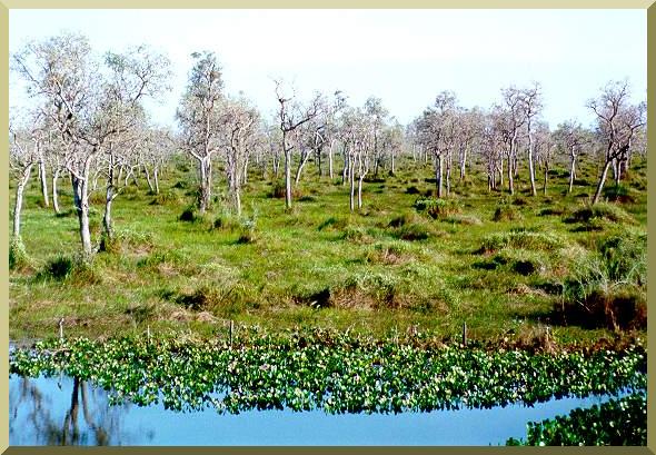
| The Pantanal of Jacadigo-Nabileque, near Corumbá, Mato Grosso do Sul. |