[0709051130]
The hydroecology of selected vegetative species in the Tierra del Sol watershed, in San Diego County, California, will be studied. The selected species are blue elderberry (Sambucus Mexicana) and red shank (Adenostoma sparsifolium). The Tierra del Sol watershed is a 2.75 square-mile watershed located immediately north of the U.S.-Mexican border and east of the Campo Indian reservation, in the San Diego backcountry. The proposed Campo landfill is adjacent to the Tierra del Sol watershed and within the confines of the Indian reservation. The landfill is expected to have a negative impact on the hydrology of the Tierra del Sol watershed. The impact is predicted to extend downstream to the community of Roca Magisterial, on the other side of the U.S.-Mexican border.
The Tierra del Sol watershed features many vegetative lineaments, which are an indication of the presence of rock fractures. Specimens of blue elderberry and red shank are significantly represented along these lineaments. The study will seek to explain the peculiar alignment of these specimens in terms of a sustained moisture source, which could be linked to the groundwater. While the hydroecologies of blue elderberry and red shank are known from a conceptual standpoint, no studies have been found which document the seasonal variations of moisture at the root level, with specific aim to explain the local biogeography. Thus, this study will be the first to connect the water affinities of blue elderberry and red shank to the presence of a sustained moisture source which could be attributed to the rock fractures.
Twelve measuring sites will be chosen, four for each of three species: two study species (blue elderberry and red shank) and one control species (chamise, or Adenostoma fasciculatum). The soil-moisture content will be measured with a commercial moisture sensor. The latter measures soil moisture every inch of the way from the soil surface to the bottom of the access tubes. At each site, measurements will be taken twice a month, for a period of 18 months. The findings will seek to support the hypothesis that the study sites have a sustained moisture source, which being fed from groundwater, is weakly dependent on the season. On the other hand, the control site will rely only on rainfed soil moisture and, thus, be strongly dependent on the season.
The findings of this study can help the people of Tierra del Sol, many of whom oppose the landfill project, to further advance the notion that siting landfills on a fractured rock aquifer constitutes a veritable public health hazard. Moreover, the Tierra del Sol aquifer has been designated in 1993 as "sole source" by the Environmental Protection Agency. The Tierra del Sol aquifer supplies more than fifty percent of the drinking water, and there are no reasonably available alternative sources should the aquifer become contaminated.
The total amount requested is $48,000.
A. Statement of the Problem/Need/Relevance
The hydroecology of selected vegetative species in the Tierra del Sol watershed in San Diego County, California, will be studied. Hydroecology studies the water affinities of vegetative species and their adaptations to moisture gradients. The latter are present in the environment due to local geology and geomorphology. The Tierra del Sol watershed is a 2.75 square-mile watershed located immediately north of the U.S.-Mexican border and east of the Campo Indian reservation, in the San Diego backcountry (Fig. 1). A landfill is currently being planned in the area adjacent to and west of the Tierra del Sol watershed, within the confines of the Campo Indian reservation.
The landfill is expected to have a negative impact on the hydrology of the Tierra del Sol watershed, including its aquifer and nascent streams. The problem is how to accurately assess the extent of the impact and the associated risks to public health. The Tierra del Sol aquifer sits on fractured rock, which means that its hydrogeology is dominated by convection, rather than by diffusion, as would be the case in a more traditional hydrogeological setting. Convection-dominated flows travel to target locations within hours or days, instead of the more usual months or years for comparable diffusion-dominated flows. Thus, accidents and mishaps would be much more difficult to contain in a fractured-rock aquifer setting.
There is an urgent need to characterize the Tierra del Sol aquifer and demonstrate beyond a reasonable doubt its fractured-rock aquifer properties. To this end, there is already ample geophysical, hydrogeological, and other evidence that the entire watershed is underlain by extensively fractured rock. However, the hydroecological aspects remain to be clearly elucidated. A hydroecological study can provide proof of the existence of geological moisture gradients, which otherwise may prove difficult to document. The study focuses on the lineaments, which are readily observed vegetative features of the landscape, their presence being directly traced to the moisture gradients. Lineaments provide an effective way of identifying loci of moisture concentration which may be linked to the rock fractures.
The relevance of the proposed study is assured. The distribution and extent of the rock fractures will be studied through the singular perspective of hydroecology. It is noted that the Tierra del Sol aquifer is part of the Campo-Cottonwood Sole Source aquifer of eastern San Diego County. The Campo-Cottonwood Sole Source Aquifer was designated as such on May 5, 1993, under the authority of Section 1424(e) of the Safe Drinking Water Act. An aquifer can be named a Sole Source Aquifer by the Administrator of the Environmental Protection Agency if the aquifer supplies fifty percent or more of the drinking water for an area and there are no reasonably available alternative sources should the aquifer become contaminated. Thus, the proposed landfill will place at risk the entire population of Tierra del Sol. Since the aquifer is linked to the surface waters through springs and nascent streams, the risk of contamination will extend downstream into the neighboring community of Roca Magisterial, in Baja California, Mexico. The binational nature of the problem and the associated risk cannot be overemphasized.
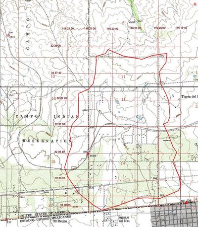 |
| Fig. 1 Tierra del Sol watershed, in San Diego County, California. |
B. Objective(s)/Outcomes
The hydroecological study will determine the water affinities of two vegetative species present in the Tierra del Sol watershed. These are the blue elderberry (Sambucus Mexicana) and the red shank (Adenostoma sparsifolium). In Tierra del Sol, both of these species appear to be aligned along readily identifiable lineaments, revealing the presence of clearly defined moisture gradients (Ponce, 2006). For red shank, in particular, the lineaments can be observed in digitally enhanced infrared images, as shown by the marked red line which cuts across the bottom right-hand corner of Fig. 2.
For the two selected vegetative species, the accomplishment will be the development of the cause-effect relation between the lineaments and the prevailing soil moisture. The outcome will be the seasonal and mean annual water supply of these two species in their respective lineaments, as measured by the soil-moisture content at the root level. Deliverables will include an analysis of the relation between selected individual specimens and their soil-moisture environment, and a comparison with a suitable control species such as the chamise (Adenostoma fasciculatum) (Marion, 1943). Four sites for each of three species (two target species and one control species), with a total of twelve measuring sites are initially considered in the testing program. Biweekly measurements will span a minimum period of 18 months, and may continue for up to 36 months as deemed necessary, contingent upon resources.
The responsible party for the hydroecological study will be Dr. Victor M. Ponce, Principal Investigator. Dr. Ponce has thirty years of experience in hydrology, fifteen years in hydroecology, and two years with the hydrology and hydrogeology of the Tierra del Sol watershed. The field work and laboratory analysis will be performed by a graduate student of the Civil and Environmental Engineering Department, to be designated at the appropriate time. A Master's thesis will be developed as a direct result of the research subject of this study.
The benefit of this project will be a better understanding of the relation between vegetative lineaments and rock fractures in the Tierra del Sol watershed. The objective is to show, beyond a reasonable doubt, that the lineaments exist because of the presence of the rock fractures; or, in other words, that the latter provide the moisture gradients which facilitate the lineaments' existence. The finding will support the argument that the Tierra del Sol aquifer is indeed a very active fractured-rock aquifer, and thus, one where a landfill siting will result in a high risk of [sole-source] aquifer contamination and a veritable public health hazard.
The measures of effectiveness of this project will be a publication of the findings in a recognized peer-reviewed journal. Online publication of selected findings will make the research quickly available to scientific peers on a global basis. Overall, success will be measured by the extent to which the findings can be used by the people of Tierra del Sol, the majority of whom oppose the landfill project, and other stakeholders to convince state and federal officials that siting landfills on fractured-rock aquifers is an extremely risky proposition. Every measure should be taken at multiple societal levels to discourage this activity. Water is a precious resource, and no project, however economically enticing to its backers, should be allowed to compromise the quantity and/or quality of a scarce regional resource.
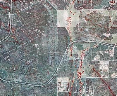 |
| Fig. 2 Infrared image of the central portion of the Tierra del Sol watershed, showing a red shank-dominated community cutting across the bottom right-hand corner. |
C. Research Method/Approach
Two closely related chaparral species, chamise (Adenostoma fasciculatum) and red shank (Adenostoma sparsifolium) are significantly represented in the Tierra del Sol watershed. Although congeners, these two species are not at all alike in appearance. Stands of chamise chaparral are dull, dark-green in color and uniform in appearance. The mature chamise plant is a medium-sized shrub 2 to 8 feet tall, with sparse leaf litter. In contrast, red shank is a tall, round-topped arborescent plant 6 to 20 feet high, with thick, naked stems and considerable leaf litter, 0.5 to 2 inches in depth. Red shank appears to dominate over chamise on sites with higher moisture content, organic matter, and nutrient availability (Beatty, 1984).
Hanes (1965) noted that though both Adenostoma species resumed growth in early winter, chamise displayed a sudden flush of growth in the spring, whereas red shank grew more steadily, with continued growth throughout the summer and fall. Chamise flowered in April and May, whereas red shank flowered abundantly in August. While chamise has an apparent enforced dormancy in the fall, red shank has been known to experience substantial autumnal growth, suggesting a sustained moisture source.
Despite being sclerophyllous, red shank can be shown to violate several definitions of sclerophyllous plants. First, it remains physiologically active during summer drought; thus, it is drought tolerant without being drought dormant (Hanes, 1965). Secondly, its root morphology is unique among the chaparral. Its shallow root system suggests that its moisture for summer growth must come from the top layers of the substrate. Red shank seems to be a type of shrub well adapted to drought conditions, but lacking the obvious morphological characteristics suggesting such adaptability (Shreve, 1934). Thus, the water affinities of red shank lie in between those of the xerophytes, which are well adapted to drought, and those of the mesophytes, which habitually require a more sustained moisture source. In semiarid regions, this ecological niche must be connected to the presence of groundwater, or, at the very least, to plenty of vadose moisture, which suggests the close proximity to groundwater.
The blue elderberry is present in the flood plains and other mesic locations of the Tierra del Sol watershed (Fig. 3). The water affinities of the blue elderberry and its preeminent role as an indicator of groundwater have been known for almost one hundred years. Early references to the blue elderberry's moisture habits are scattered throughout the literature. Ball (1907) has stated that in Southwestern Nevada and Eastern California, the elderberry tree is unknown, except in the vicinity of water. Spalding (1909) has noted that the blue elderberry, while being structurally a flood-plain mesophyte, is nevertheless very limited in its range, growing where there is an ample supply of moisture, such as near irrigation ditches.
In the Southwestern United States, particularly in Southern California's inland hillslopes, the blue elderberry may be thought of as a meso-hygrophyte, to indicate that while structurally a mesophyte (Meinzer, 1927), its water habits resemble those of a hygrophyte, which thrives on wet soil and is more or less restricted to wet sites. In semiarid regions such as the San Diego backcountry, this unique ecological niche appears to be connected to the presence of groundwater.
 |
| Fig. 3 Specimen of blue elderberry, in the Morning Star Ranch, Tierra del Sol (photo dated May 11, 2006). |
The study will be divided into four phases:
- Literature review
A review will be conducted of the hydroecology of the three selected vegetative species: two study species, the blue elderberry (Sambucus Mexicana) and the red shank (Adenostoma sparsifolium), and one control species, the chamise (Adenostoma fasciculatum). The water affinities and adaptations of these three species, in terms of their aerial morphology, and root depth, density, shape, structure and spatial extent will be sought. The geographical distribution of the three selected species, in Southern California and elsewhere, will be sought. To the extent possible, the geographical distribution will be explained in terms of local geology and geomorphology.
- Field data collection
Twelve soil-moisture sites will be established in the field, four sites for each of three species named in item 1. The sites for the blue elderberry will be selected in the vicinity of the Morning Star Ranch, in Tierra del Sol. Forty-three specimens of blue elderberry have been mapped in the Morning Star Ranch and vicinity (Ponce, 2006). The owners of the ranch, Mr. and Mrs. Ed Tisdale, have agreed to facilitate the field data collection on their premises. The red shank sites will be selected in the vicinity of the lineament shown in Fig. 2. There are hundreds of specimens of red shank on that lineament. Many of them would be suitable for this study. The lineament crosses the Willoughby and Hope ranches. The owners, Helen Willoughby and Jerry Hope, have agreed to facilitate the field data collection on their premises. The sites for the chamise will be chosen off the lineaments in the Tierra del Sol watershed, within the Morning Star, Willoughby, and Hope ranches. The measurements will be fortnightly, for a period of no less than 18 months, and up to 36 months, the latter depending on resource availability. Local experience suggests specific attention, in the field mesurements as well as in the data analysis, to the effect of the gravitational pull of the moon (a full moon) on the shallow groundwater levels in the vicinity of the fractures (Tisdale, 2006).
- Data analysis
Twelve measurements, taken twice a month for 18 months will provide a total of 432 data points. The analysis will seek to support the hypothesis that the study sites, corresponding to the blue elderberry and red shank, have a sustained moisture source which is weakly dependent of the season. On the other hand, the control site, corresponding to the chamise, would have a soil moisture which is strongly dependent on the season. The differences in moisture would be correlated with the presence or absence of vegetative lineaments, the fractures on which they are sustained, and the local moisture gradients that these fractures enable. If necessary to clarify the trend, the data analysis may be complemented with a geophysical wave propagation test. The latter is designed to identify changes in bulk soil properties that may be linked to the rock fractures.
- Reporting
A report will be written with the documented research findings. A version of the report will be submitted for publication in a recognized journal, such as the Journal of Biogeography or the International Journal of Ecohydrology and Hydrobiology. Another version of the report will be written in layperson's terms and made available online for users to benefit on a global scale.
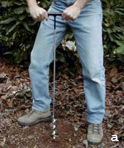
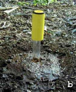
The soil moisture will be measured with an Aqua-Pro "capacitance" moisture sensor. The moisture probe transmits a very low powered radio frequency through the soil to measure moisture. There are two copper bands (radio antennas) on the end of the sensor. One antenna transmits a low powered radio frequency signal that is received by the other antenna. The proprietary microprocessor can determine the moisture by the change in frequency of the signal it receives. The more moisture in the soil, the greater the shift in the frequency of the signal. The moisture sensor has a repeatable accuracy of plus or minus 2%, and the moisture meter has a resolution of 1% (dry is 0% and water is 100%).
Aqua-Pro sensors measure soil moisture every inch of the way from the soil surface to the bottom of the access tubes. The profiling probe is lowered into a polycarbonate tube that has previously been inserted into the soil. The polycarbonate tubes come in 1-meter lengths but can be extended to 2-meter or greater lengths if necessary, by connecting them together. The readout from the radio frequency sensor is percent available moisture. The field procedure is: (a) drill a hole to the maximum depth of moisture measurement desired, estimated at 2 m at this time; (b) insert the polycarbonate access tube in the hole; and (c) insert the probe in the access tube and lower it to the bottom to record moisture (Fig. 4 a, b, and c).
 |
 |
 |
| Fig. 4 Installation and use of Aqua-Pro moisture probe. |
The principal investigator, Dr. Victor M. Ponce will direct the overall study and assist in choosing the data collection sites. The graduate student will perform the literature review, field data collection, and data analysis. The report writing will be performed by the graduate student, under the supervision of the Principal Investigator. Dr. Julio Valdes will participate in the initial stages of the field research and supervise the installation of the access tubes. Dr. Valdes will also assist with data interpretation. The online posting will be performed by students at the SDSU Visualab.
The project duration is 18 months, starting June 1, 2007 and ending November 30, 2008.
A breakdown of tasks and estimated duration is given below.
REFERENCES
Ball, S. H. (1907). A geologic reconnaisance of Southwestern Nevada and Eastern California.
U.S. Geological Survey Bulletin No. 308, United States Government Printing Office, Washington, D.C.
Beatty, S. W. (1984). Vegetation and soil patterns in Southern California chaparral communities.
In B. Dell, editor, Medecos IV: Proceedings, 4th International Conference on Mediterranean Ecosystems, August 13-17,
1984, The Botany Department, University of Western Australia, Nedlands, Australia, 4-5.
Hanes, T. L. (1965). Ecological studies of two closely related chaparral shrubs in Southern California. Ecological Monographs, 35(2), 213-235.
Marion, L. H. (1943). The distribution of Adenostoma sparsifolium. American Midland Naturalist, 29(1), January, 106-116.
Meinzer, O. E. (1927). Plants as indicators of ground water. U.S.
Geological Survey Water-Supply Paper No. 577, United States Government Printing Office, Washington, D.C.
Ponce, V. M. (2006). Impact of the proposed Campo landfill on the hydrology of the Tierra del Sol watershed. Online report.
http://tierradelsol.sdsu.edu.
Shreve, F. (1934). The problems of the desert. The Scientific Monthly, 38(3), March, 199-209.
Spalding, V. M. (1909). Distribution and movement of desert plants. Publication No. 113,
Carnegie Institution of Washington, Washington, D.C., 5-17.
Tisdale, Ed. (2006). Personnal communication.
D. Qualifications/Appropriateness of Research Team
E. Schedule
- Discuss the activities to be performed or hypothesis to be tested and criteria for determining acceptable quality.
- Describe the study design, including sample type, location requirements,
and any statistical analyses that were used to estimate
the types and numbers of samples required for physical samples.
Twelve sites will be chosen during an initial field trip in which entire research team will participate. The sites will be chosen to represent the blue elderberry and the red shank within the previously identified lineaments, and the chamise (control species) outside of the lineaments (See Section A of the Project Description). The preferred sites will be those that are within 500 ft of the access roads, for distance convenience and to minimize the possibility of vandalism. The location of the access tubes will be next to the chosen study specimen, in the vicinity of the area of influence of the root structure. The number of measuring sites, four for each of three species, for a total of twelve sites, is considered sufficient to satisfy economic constraints (the cost of each access tube and installation), while guaranteeing test repeatability.
- Describe the procedure for the handling and custody of samples, including sample collection, identification, preservation, transportation, and storage.
The measurements will consists of electronic soil-moisture readings at various levels within the access tubes, to cover the range of root depth. There will be no collection of samples.
- Describe the procedures that will be used in the calibration and performance evaluation of the sampling and analytical methods, and describe the equipment to be used during the project.
The soil moisture will be measured with a commercial Aqua-Pro "capacitance" moisture sensor. The moisture probe transmits a very low powered radio frequency through the soil to measure moisture. The proprietary microprocessor is calibrated at the factory to determine the soil moisture by the change in frequency of the signal it receives. Since the moisture measurement is indirect, and relative values are paramount, no local calibration is necessary. However, sufficient care must to be taken to ensure that the probe remains in working order during the measuring period.
- Discuss the procedures for data reduction and reporting, including a description of statistical analyses to be used and for any computer models that will be designed or used with associated verification and validation techniques.
The soil-moisture measurements will be made twice a month, for a period of 18 months, for 12 measuring locations or boreholes. This gives a total of 432 data points. The analysis will seek to detect any strong or otherwise significant trend in seasonal soil-moisture dependency in the control site (expected to be low at the beginning of the rainy season, and high at the beginning of the dry season). Conversely, no such strong or significant trend is expected in the two study sites. Trend analysis using SPSS and related software will be used for this stage of the research. Infrequent storms and the moon's phase (See Item 2 of Section C of the Project Description) will be taken into account in the data analysis and reduction.
- Describe the quantitative and/or qualitative procedures that will be used to evaluate the success of the project, including any plans for peer or other reviews of the study design or analytical methods prior to data collection.
Prior to data collection, the research team will seek a peer review of the study design. The success of the project will be evaluated by the degree to which the two study sites and one control site show different soil-moisture signatures across an 18-month measuring period. If necessary to clarify the trend, the measuring period will be extended to 36 months. The findings will be communicated to the stakeholders of Tierra del Sol, to empower them to better argue their case for the defense of their sole-source aquifer from contamination.
- Describe the procedure for the handling and custody of samples, including sample collection, identification, preservation, transportation, and storage.
Twelve soil-moisture measuring sites will be established in the field, four sites for each of three species (two study species and one control species) (See item 2 of Section C of the Project Description). We will test the hypothesis that the study sites, corresponding to the blue elderberry and red shank, have a sustained moisture source, which is weakly dependent of the season. Conversely, the control site, corresponding to the chamise, is expected to have a soil moisture which is strongly dependent on the season. The soil-moisture meter has a repeatable accuracy of plus/minus 2 percent, and a resolution of 1 percent. Soil moisture can vary from 0 percent (dry soil) up to 100 percent (water).