ECOHYDROLOGY OF RED SHANK IN THE TIERRA DEL SOL WATERSHED,
SAN DIEGO COUNTY, CALIFORNIA
DR. VICTOR M. PONCE AND LUIS A. MAGALLON
08 February 2014
1. INTRODUCTION
This field study will examine the ecohydrology and related water affinity of red shank (Adenostoma sparsifolium), an arborescent plant that is significantly represented in the Tierra del Sol watershed, in southeast San Diego County, California (Fig. 1). The objective is to measure soil moisture and related moisture gradients that condition the growth of red shank from chaparral shrub size (6 ft) to tree size (18 ft). A direct relationship between tree height and prevailing soil moisture is sought.
The study findings will support the argument that tall red shank lineaments in Tierra del Sol are primarily supported by groundwater. Therefore, excessive pumping of groundwater in the vicinity may affect the normal functioning of the red shank vegetative ecosystems.
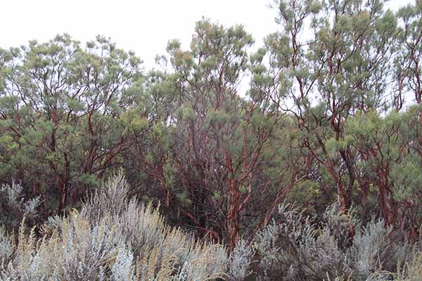 |
| Fig. 1 A community of red shank, in Tierra del Sol, San Diego County, California. |
The Tierra del Sol watershed is a 2.75 square-mile watershed located immediately north of the U.S.-Mexican border in southeast San Diego County. The watershed in entirely underlain by fractured rock, which means that its hydrogeology is dominated by convection through the fractures, rather than by diffusion through the pores or matrix. This study focuses on the lineaments, which are readily observed vegetative features of the landscape (Fig. 2). Lineaments provide an effective way of identifying loci of moisture concentration which may be related to the presence of rock fractures.
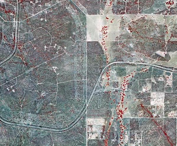 |
| Fig. 2 Red shank lineament, shown in red color on the bottom right corner of this infrared image. |
3. OBJECTIVE
This study seeks to establish a cause-effect relation between the vegetative lineaments and the prevailing soil moisture. The objective is to show that the lineaments exist because of the presence of the rock fractures; or, in other words, that the latter provide the moisture gradients which facilitate the lineaments' existence. The finding will support the argument that the Tierra del Sol aquifer is indeed a very active fractured-rock aquifer, where convective groundwater flow predominates over diffusive flow.
Two closely related chaparral species, chamise (Adenostoma fasciculatum) and red shank (Adenostoma sparsifolium) are significantly represented in the Tierra del Sol watershed. Although congeners, these two species are not at all alike in appearance. Stands of chamise chaparral are dull, dark-green in color and uniform in appearance. The mature chamise plant is a medium-sized shrub 2 to 8 feet tall, with sparse leaf litter. In contrast, red shank is a tall, round-topped arborescent plant 6 to 18 feet high, with thick, naked stems and considerable leaf litter, 0.5 to 2 inches in depth. Red shank appears to dominate over chamise on sites with higher moisture content, organic matter, and nutrient availability (Beatty, 1984).
Despite being sclerophyllous, red shank can be shown to violate several definitions of sclerophyllous plants. First, it remains physiologically active during summer drought; thus, it is drought tolerant without being drought dormant (Hanes, 1965). Secondly, its root morphology is unique among the chaparral. Its shallow root system suggests that its moisture for summer growth must come from the top layers of the substrate. Red shank seems to be a type of shrub well adapted to drought conditions, but lacking the obvious morphological characteristics suggesting such adaptability (Shreve, 1934). Thus, the water affinities of red shank lie in between those of the xerophytes, which are well adapted to drought, and those of the mesophytes, which habitually require a more sustained moisture source. In semiarid regions, this ecological niche must be connected to the presence of groundwater, or, at the very least, to plenty of vadose moisture, which suggests the close proximity to groundwater.
4. METHODOLOGY
The study will be divided into three phases:
- Field data collection
Three soil-moisture sites will be established in the field. These sites will consist of two locations each: (a) the target location, the tall red shank, of up to 18 ft high, and (2) the control location, the small red shank or the chamise, of 6-10 ft high. Within each one of the three measuring sites, the two sampling locations will be chosen: (1) inside, and (2) outside, of the lineament shown in Fig. 2. The measurements will be done fortnightly, for a period of 24 months. Local experience suggests specific attention, in the field mesurements as well as in the data analysis, to the effect of the gravitational pull of the moon (a full moon) on the shallow groundwater levels in the vicinity of the fractures.
- Data analysis
Six (6) measurements, taken twice a month for 24 months, will provide a total of 288 data points. The analysis will seek to support the hypothesis that the target locations have a sustained moisture source which may be attributed to the close presence of groundwater. The effect of local precipitation will be accounted for in the analysis.
- Reporting
A report will be written to document the research findings. The report will be published in http://ponce.sdsu.edu. A paper will be prepared for publication in a recognized journal of ecohydrology.
5. FIELD MEASUREMENTS
The soil moisture will be measured with an Aqua-Pro "capacitance" moisture sensor. The moisture probe transmits a very low powered radio frequency through the soil to measure moisture. There are two copper bands (radio antennas) on the end of the sensor. One antenna transmits a low powered radio frequency signal that is received by the other antenna. The proprietary microprocessor can determine the moisture by the change in frequency of the signal it receives. The more moisture in the soil, the greater the shift in the frequency of the signal. The moisture sensor has a repeatable accuracy of plus or minus 2%, and the moisture meter has a resolution of 1% (dry is 0% and water is 100%).
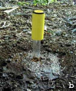
Aqua-Pro sensors measure soil moisture every inch of the way from the soil surface to the bottom of the access tubes. The profiling probe is lowered into a polycarbonate tube that has previously been inserted into the soil. The polycarbonate tubes come in 3-ft lengths but can be extended to 6-ft or greater lengths if necessary, by connecting them together. The readout from the radio frequency sensor is percent available moisture. The field procedure is: (a) drill a hole to the maximum depth of moisture measurement desired, estimated at 6 ft (Fig. 3a); (b) insert the polycarbonate access tube in the hole (Fig. 3b); and (c) insert the probe in the access tube and lower it to the bottom to record moisture (Fig. 3c).
 |
 |
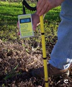 |
| Fig. 3 Installation and use of Aqua-Pro moisture probe. |
The project duration is 24 months, starting March 1, 2014 and ending February 29, 2016.
The budget to support Luis A. Magallon on the
inception stage of the study (first 5 months) is U.S. $2,000.
7. REFERENCES
Beatty, S. W. (1984). Vegetation and soil patterns in Southern California chaparral communities.
In B. Dell, editor, Medecos IV: Proceedings, 4th International Conference on Mediterranean Ecosystems, August 13-17,
1984, The Botany Department, University of Western Australia, Nedlands, Australia, 4-5.
Hanes, T. L. (1965). Ecological studies of two closely related chaparral shrubs in Southern California. Ecological Monographs, 35(2), 213-235.
Shreve, F. (1934). The problems of the desert. The Scientific Monthly, 38(3), March, 199-209.
6. SCHEDULE AND BUDGET
140208