 |
|
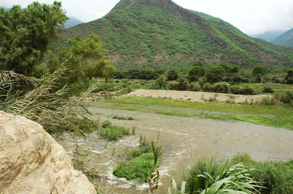
Fig. 1 Proposed damsite on La Leche river at |
LAMBAYEQUE, PERU
FIRST PROJECT REPORT
March 18, 2008
Dr. Victor M. Ponce
Hydrology Consultant
1. INTRODUCTION
D'Leon Consulting Engineers, of Long Beach, California, hereafter referred to as DLCE,
has a contract with the Regional Government of Lambayeque, Peru, hereafter RGL,
to support the development of the La Leche River flood control project.
The study aims to enhance flood control and water conservation in the watershed of the La Leche river, which has
suffered major floods caused by the El Niño phenomenon.
The funding agency is the U.S. Trade and Development Agency (UST&DA).
The local government agency in charge of the project is the Proyecto Especial Olmos-Tinajones, hereafter PEOT.
Dr. Victor M. Ponce, hereafter the Consultant or VMP, has a subcontract with DLCE
to perform the hydrologic component of the study.
This first report is submitted in partial fulfillment of the requirements of the contract between VMP and DLCE.
The report encompasses the initial review of the project, including the available data, and the impressions gathered by the Consultant
as a result of the field visit of February 11-15, 2008.
2. FIELD VISIT
On February 9, 2008, the Consultant traveled from his place of residence in San Diego, California, to Lima, Peru, and shortly thereafter
to Chiclayo, Peru. The Consultant returned to San Diego
on February 17. The visit began on Monday, February 11, and ended on Friday, February 15.
The DLCE team consisted of Domingo Leon Ezcurra (DLE), project leader, Francisco Javier Sanchez Caro (FJSC), geotechnical and dam safety consultant,
Jack Ferguson (JF), geology consultant, and VMP, hydrology consultant.
On Monday, February 11, the Consultant participated in a first meeting held at the offices of RGL in Chiclayo, for the purpose of informing
PEOT staff about the scope of the study to be performed by the DLCE team.
On Tuesday, February 12, the Consultant traveled to the field accompanied by DLE and
FJSC and Pastor Espinoza Chilon, staff civil engineer with PEOT. The team inspected the watershed of the La Leche river,
moving in an upstream direction to the headwaters of the Moyan river,
one of two branches of the La Leche River. [The other tributary branch is the Sangana river].
The DLCE team spent the night in the town of Incahuasi, nested high in the Andes Mountains
at an elevation of 3,605 m, near the headwaters of the Moyan river.
On Wednesday, February 13, the DLCE team returned to Chiclayo.
During the return trip, the team further inspected the watersheds of the Moyan and La Leche rivers.
The watershed of the Sangana and Tocmoche rivers was not visited on this occasion.
The team inspected the left (south) abutment of the proposed La Calzada (La Calera) damsite.
On Thursday, February 14, the entire team, including the geologist JF, visited the proposed Calicantro damsite and the vicinity of the right
abutment (north) of the proposed La Calzada damsite. The team gathered first-hand data on the conditions at the proposed damsites.
On Friday, February 15, the team held a second business meeting at the offices of PEOT. The team members gave technical presentations
regarding the project scope and objectives. In the afternoon, the Consultant visited the Tinajones project,
on the neighboring Chancay river to the south, to observe first-hand the extent of the sedimentation problems at this existing reservoir.
 |
|
Fig. 2 The town of Incahuasi, nested deep on the |
||||||||||||||||||||||||||||||||||||||||||||||||||||||||||||||||||||||||||||||||||||||||
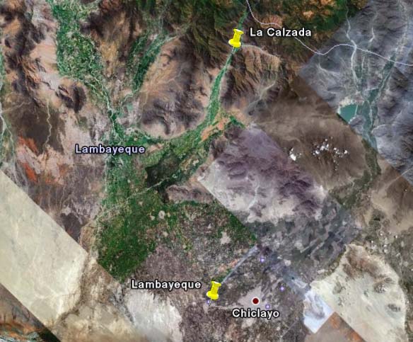 |
| Fig. 3 Satellite view of the conjoined La Leche and Chancay-Lambayeque valleys (Source: Google Earth). |
5. RETURN PERIOD FOR DESIGN
An important consideration in a dam/spillway project is the choice of return periods to be used for design.
In the United States, current practice by the USDA Natural Resources Conservation Service (NRCS) stipulates
the minimum design criteria for principal and emergency spillways. This criteria encompasses frequency-based precipitations up to
P100 (100-yr frequency precipitation), and the PMP (Probable Maximum Precipitation), depending on
the applicable case (Natural Resources Conservation Service, 1960).
In countries where suitable PMP's are lacking,
the P10,000 (10,000-yr frequency precipitation) is commonly used as a surrogate for the PMP.
The P10,000 implies a timespan of
about 400 human generations, which is generally taken as a practical upper limit for frequency-based flood studies (Ponce, 1989).
According to NRCS practice,
the proposed La Leche dam would rate as a class (c) dam. This dam is located where failure may cause loss of life and
serious damage to homes,
industrial and commercial buildings, important public utilities, and main highways.
[It is noted that dam-breach floods have been known to exceed the 10,000-yr flood].
The towns of Íllimo, Túcume
and Mochumí could be at risk of catastrophic flooding.
The Panamerican Highway, a major regional transportation artery, would also be at risk in the event of an extreme flood arising
from a dam failure.
Given the mild relief of the lower La Leche valley, it is very possible that the La Leche river could jump its normal
boundaries during unusual flood stages.
If this happens, the city of Lambayeque could lie along the path of a postulated dam-breach flood wave (see Fig. 3).
Note that in the El Niño event of 1983, the city of Lambayeque was spared from flooding only by the diversion of the floodwaters to
an existing drain, averting what could have been a sure catastrophe (Consorcio Salzgitter-Lagesa, 1984).
NRCS design criteria considers two types of spillways: (1) principal spilways, and (2) emergency spillways.
The principal spillway hydrograph is used to determine the capacity of: (a) the principal spillway,
(b) the emergency-spillway crest elevation, and (c) the volume of retarding pool storage.
The emergency spillway hydrograph is used to determine the capacity of: (a) the emergency spillway,
(b) the maximum design-pool elevation, and (c) the volume of surcharge storage (Fig. 4).
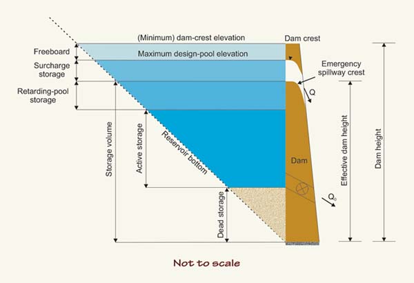 |
| Fig. 4 Definition sketch for reservoir storage volumes (Ponce, 1989). |
For the design of a principal spillway for a class (c) dam, NRCS recommends, as a minimum (Natural Resources Conservation Service, 1960):
| Ppsh = P100 | (Eq. 1) |
For the design of the emergency spillway for a class (c) dam, NRCS recommends, as a minimum:
| Pesh = P100 + 0.26 (PMP - P100) | (Eq. 2) |
For the case of Lambayeque, the PMP should be practically interpreted as the P10,000. Thus, as a minimum, the emergency spillway should be designed to pass the flood caused by:
| Pesh = 0.74 P100 + 0.26 P10,000 | (Eq. 3) |
NRCS has an additional provision for the design of an emergency spillway. This provision is embodied in the concept of the freeboard hydrograph, i.e., the flood hydrograph that will take up all the available freeboard (Fig. 4). To develop the freeboard hydrograph for a class (c) dam, NRCS recommends the PMP. Thus, as a minimum, the freeboard hydrograph should correspond to a flood caused by:
| Pfbh = P10,000 | (Eq. 4) |
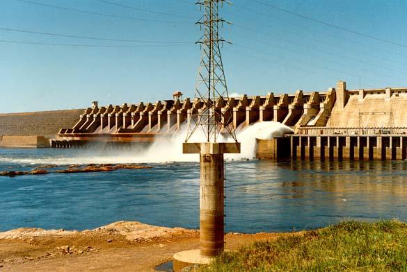
The safety of the embankment against catastrophic floods requires that the emergency spillway be designed with return periods up to 10,000 years (see, for instance, the Tucurui spillway shown in Fig. 5). In addition, PEOT must make sure that it has in place the proper procedures to ensure that the reservoir is operated as designed in the event of a major flood. The volume of retarding-pool storage should be maintained at all times, but particularly during El Niño years.
A 1984 study considers return periods of 25 and 50 years for event precipitation related to El Niño (Consorcio Salzgitter-Lagesa, 1984; p. 4.3-22). Furthermore, it interprets these as the flood peaks with return periods of 50 and 100 years, respectively (sic). While return periods of 50 and 100 years are commonly used for flood protection works along the river channel (dikes and levees), hydrologic design criteria for emergency spillways are much more stringent.
 |
|
Fig. 5 Spillway at Tucurui dam, on the Tocantins river, in the |
6. TYPE OF EMERGENCY SPILLWAY
A basic consideration in dam design is the type of spillway. There are two general types of
spillway structures:
The cavitation damage of the tunnel spillway at Glen Canyon Dam (on the Colorado river, Arizona) in a June 1983 El Niño-related event, led
the U.S. Bureau of Reclamation to use aeration slots in new and reconditioned tunnel spillways.
The Morning Glory spillway is a type of tunnel spillway featured in dams built in the U.S. and other countries, including Peru.
The U.S. Army Corps of Engineers has built only two of these spillways.
The U.S. Bureau of Reclamation has built Monticello dam, west of Sacramento, California, which, with a
capacity of 1,370 m3/s,
rates as the largest Morning Glory spillway in the world.
In this spillway, the largest diameter is 22 m and the smallest diameter is about 8 m.
A Morning Glory spillway has an increased risk of failure due to clogging of the
vertical shaft with accumulations of logs and other vegetative debris.
The Consultant is aware of at least one such failure, that of the cofferdam of Barragem Norte,
on the Itajai river, in Santa Catarina, Brazil, in December of 1982 (Fig. 6).
 |
| Fig. 6 Failure of the cofferdam of
|
The possibility of clogging is real and, for most part, unpredictable. One way to minimize the possibility of clogging is to build the shaft of a diameter large enough to pass all large trees or logs. In this respect, the guidelines of the French National Committee of ICOLD (International Committee on Large Dams) specify that all Morning Glory (shaft) spillways should have a minimum throat diameter of 6 m (Hydrocoop.org, 2008).
Experience shows that cavitation may also be a problem in a Morning Glory spillway, since very high flow velocities are possible with high dams. In any case, a Morning Glory could only be considered as a principal spillway, and not as an emergency spillway. Given the perceived need to handle very large design flood discharges, most likely in the range of several thousands of cubic meters per second, a Morning Glory spillway should not be used as an emergency spillway for the La Leche river flood control project.
Gated spillways should be avoided due to the possibility of equipment malfunctioning precisely when it is most needed, i.e., during a major flood. This is particularly important in the case of the La Leche watershed, where the time of concentration during infrequent floods may be as short as 3 hr. For gated spillway(s), built-in system redundancies (backup equipment, a heliport for quick emergency access, etc.) will help minimize the risk of failure.
7. FLOOD HYDROLOGY
At the proposed La Calzada damsite, the watershed of the La Leche river has a drainage area of 907.36 km2.
A preliminary appraisal of the relative magnitude of an unusual flood can be accomplished using the Creager formula (Creager et al., 1945).
Creager collected data from hundreds of cases all over the world, and developed an empirical flood peak formula that accounted
for hydrograph [runoff] diffusion as a function of watershed/basin size (Fig. 7).
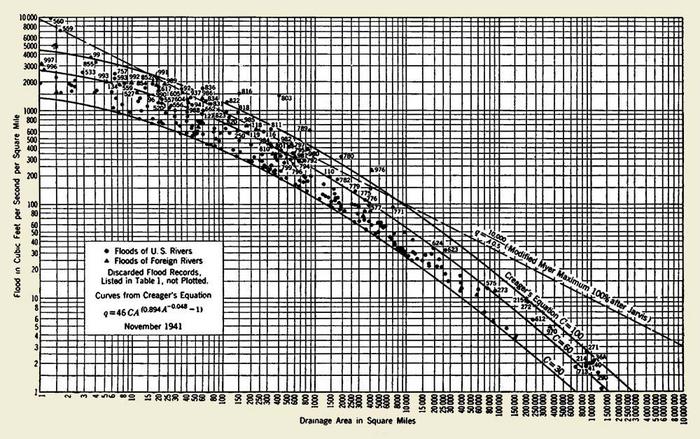 |
Fig. 7 Creager's curves (Creager et al., 1945).
Using Creager's formula, given the La Leche drainage area at La Calzada, the most unusual peak discharge (C = 100) at the damsite would be 6,792 m3/s. This value is about six (6) times greater than the 1983 El Niño peak flood discharge of 1,198 m3/s estimated by Consorcio Salzgitter-Lagesa (1984). It is also more than seven (7) times greater than the 100-yr peak flood discharge of 936 m3/s estimated by DEPOLTI (1998).
Another quick appraisal of the magnitude of an unusual flood can be made by using the NRCS TR-55 graphical method for peak discharge determination (Natural Resources Conservation Service, 1986; Ponce, 1989). As in Creager's case, this methodology also accounts for hydrograph diffusion, but it is limited to watersheds or basins with time of concentration less than 10 hr, considered as "small" by TR-55. The estimated time of concentration under extreme flood conditions for the La Leche river at La Calzada ranges from 3 to 4 hr, depending on the flood magnitude.
For a time of concentration tc = 3 hr, basin drainage area A = 907 km2, 24-hr rainfall depth P24 = 200 mm (applicable to the 1983 El Niño event), runoff curve number CN = 88 (hydrologic soil group C, pasture in good hydrologic condition, and antecedent moisture condition III), and storm type I (applicable to Southern and Central California), the calculated peak flow by TR-55 is: Qp = 6,872 m3/s.
Given streamflow records of limited extent (less than 100 yr), the statistical extrapolation to very long return periods (10,000 yr) does not appear to be warranted (U.S. Interagency Advisory Committee on Water Data, 1983). Therefore, the emphasis must shift to the deterministic/conceptual rainfall-runoff modeling to simulate watershed response under postulated extreme storm and flood conditions. This approach has an inherent advantage that it is hydraulic rather than hydrologic in nature. Hydraulic data can be measured at any time and in any quantity, while hydrologic data has to wait until the occurrence of an event of a certain return period. With deterministic/conceptual modeling, runoff estimates are based on readily measured physiographic characteristics such as land and channel slopes, catchment hydraulic lengths, and runoff curve numbers. The latter are based on relevant runoff-producing properties, such soil type, land use, hydrologic surface condition, and antecedent moisture condition (Ponce, 1989).
The deterministic/conceptual modeling approach to flood hydrology is doubly justified now that global warming is threatening to render the existing streamflow records obsolete. In the present context, a well built hydrologic watershed model should provide the most reliable tool presently available to predict a maximum flood discharge for the design of an emergency spillway.
The rational method is not applicable to the determination of maximum flood peaks for dam and spillway design in a regional watershed/basin such as that of the La Leche river. The reason is that the rational method does not explicitly account for runoff flood wave attenuation (runoff diffusion), which becomes increasingly important (due to channel storage) when the drainage area exceeds 2.5 km2 (Ponce, 1989). Other peak flow formulas such as Bürkli-Ziegler's, which are based solely on a simple correlation with drainage area, are judged to be too empirical to warrant application in the present context.
8. RAINFALL-RUNOFF MODELING
The Consultant will develop a deterministic/conceptual distributed rainfall-runoff computational model for application to the
La Leche river watershed, for peak flood hydrograph analysis at the proposed damsite(s). The model will calculate peak flood hydrographs
in selected locations, when presented with the storm precipitation (including depth, intensity, and duration),
and the soil and physiographic characteristics (curve numbers, land and channel slopes, and typical stream/river cross sections)
of the watershed/basin. A deterministic/conceptual model allows the determination of a range of possible flood flows, depending on the
precipitation input, hydrologic surface condition, and antecedent moisture condition.
The model is distributed in the sense that the entire La Leche basin will be subdivided into many subwatersheds, approximately thirty in number.
This allows the spatial and temporal description of the flood flows as they originate in the basin's headwaters,
and as they travel through the stream channels and collect
downstream to form a flood wave (Fig. 8). The generalized topological structure of the model enables it to consider a basin of any order;
see, for example, Ponce (1985). The rainfall-runoff transform will be the NRCS unit hydrograph, considered to be applicable for medium-sized
subbasins similar to those of La Leche. The channel routing model is the Muskingum-Cunge method, which simulates the diffusion wave model
and is based on physical hydraulic parameters such as the Seddon speed and the Hayami diffusivity (Ponce, 1989).
 |
| Fig. 8
Lagoon on the headwaters of the |
A significant feature of the model is its grid independence, which means that the calculated results [flood flows] are independent of the time and space steps used in the domain discretization. In computational hydraulic modeling, a grid-independent methodology assures stability, convergence, and consistency with the governing partial differential equations of unsteady open-channel flow (Ponce and Theurer, 1982; Ponce, 1986; Ponce, 1991).
The required data needs are the following:
- storm precipitation, including depth, intensity, and duration, for the meteorological component of the model.
- basin topology, i.e., the division of the entire La Leche basin into several subbasins for purposes of rainfall-runoff modeling and channel routing.
- subbasin drainage areas.
- soil types, to be expressed at NRCS hydrologic soil groups (A, B, C, or D).
- land use (forest, range, agriculture, urban).
- hydrologic surface condition (good, fair, poor).
- hydraulic lengths, channel slopes, and average terrain slopes, for the NRCS unit hydrograph generation.
- typical eight-point stream cross sections, for Muskingum-Cunge routing.
- representative reach Manning's n roughness coefficients (inbank, left and right overbank).
- Number 1, storm precipitation, is available up to 1998 (Pérez Becerra, 2006). The period 1999-2007 for the stations at Puchaca, Tocmoche, and Incahuasi needs to be collected. A map of isohyets of 24-hr storm precipitation is also needed [to be provided by PEOT].
- Numbers 2 and 3 (basin topology and subbasin drainage areas) are being collected based on available IGN 1:100,000 topographic maps.
- Numbers 4 and 5 (soil type and land use) are partially available in the 2006 study (Pérez Becerra, 2006). Detailed soil and land use maps used in the cited study are needed [to be provided by PEOT].
- Number 6 (hydrologic surface condition) remains to be estimated in the field.
- Number 7 (hydraulic lengths, channel slopes, and average terrain slopes) are being collected based on available IGN 1:100,000 topographic maps.
- Number 8 (typical eight-point stream cross sections) remains to be estimated in the field for each one of study reaches (approximately 20 in number).
- Number 9 (Manning's n roughness for inbank, left, and right overbank) remain to be estimated in the field. For this purpose, the online Barnes photo collection is available (http://manningsn.sdsu.edu). Only the inbank Manning's n values are given in the cited study (Pérez Becerra, 2006). They appear to have been estimated too low in the upper reaches of the Moyan and Sangana rivers. Field verification or correction is needed.
A field visit is required for the purpose of gathering the data that is still missing in order to run the model satisfactorily (items 4, 5, 6, 8, and 9). The visit will encompass the Moyan and Sangana branches, the two major tributaries of the La Leche river. The suggested approximate date for this visit is the third week of May 2008.
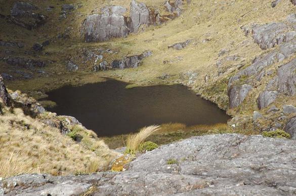
9. RESERVOIR SITE GEOMORPHOLOGY
A dam at La Calzada will create a backwater reaching to about 4 km upstream of the dam,
encompassing the mouth of Cincate Creek, a major tributary (Fig. 9).
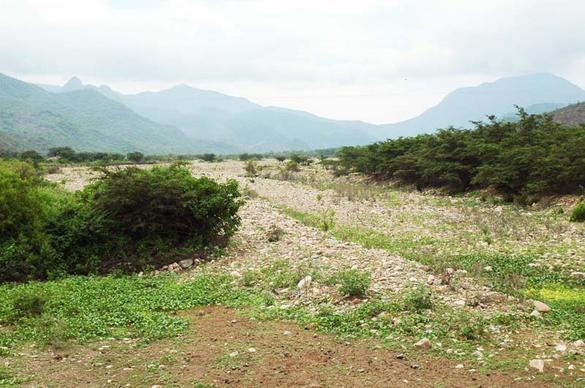
The area to be inundated by the reservoir is wide and flat (Fig. 10), created as a result of the confluence
of two large streams, La Leche River and Cincate Creek.
The latter drains an area of 85.2 km2, which amounts to
9.4% of the total drainage area of the La Leche river at La Calzada.
 |
| Fig. 9 Cincate Creek, a major tributary of the La Leche river. |
It is noted that the relatively large size of the La Leche valley at and near the mouth of Cincate Creek is in all probability due to backwater on Cincate Creek during major channel-forming floods occurring in both La Leche River and Cincate Creek simultaneously. This explains the considerable amount of sedimentation at the confluence of these two streams. It is also an indication of substantial sediment loads in both La Leche and Cincate rivers.
 |
|
Fig. 10 Proposed La Calzada reservoir site at the confluence
of |
10. RESERVOIR SEDIMENTATION
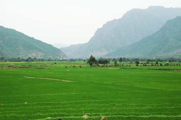
The La Leche watershed/basin is located within the western foothills of the northern Peruvian Andes, in Lambayeque department.
Terrain elevations vary from about 200 m above mean sea level
at the proposed damsite (La Calzada), to a high of 4,230 m at the peak of Cerro Choicopico, at the basin's headwaters.
The hydraulic length of the Moyan/La Leche river, from
headwaters to proposed damsite axis is 44,397 m.
[The hydraulic length of the Sangana/La Leche river is slightly larger at 44,591 m].
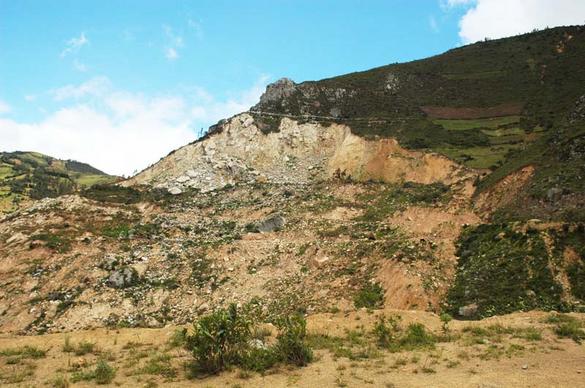
Therefore, the mean channel slope in the La Leche river is 9% (So = 0.09).
Average terrain or land slopes are on the order of 34% (Fig. 15).
Thus, it is to be expected that during a major flood-producing storm, flow velocities will be high,
runoff concentration fast, peak discharges large, and sediment loads correspondingly high.
The turbidity of the neighboring Chancay river (at Carhuaquero, Lambayeque) has been reported as 1.04 kg/m3.
The turbidity of the Jequetepeque river (at Ventanilla, La Libertad), to the south, has been reported as 3.0 kg/m3.
The turbidity of the Chira river (at Sullana, Piura), to the north, has been measured as 4.71 kg/m3,
a high value by any standard (DEPOLTI, 1998; op. cit., p. 81).
The reservoirs of Gallito Ciego and Poechos are located on the Jequetepeque and Chira rivers, respectively.
The Tinajones reservoir is an off-stream storage project located in the Chancay basin.
While Gallito Ciego and Poechos appear to be filling with sediment at a fast rate,
Tinajones is filling [with sediment] at seemingly slower rates.
There are two mechanisms that act to generate large amounts of sediment in a watershed.
The first one is natural: the mass wasting or slides, locally referred to as "huaycos," which are driven by excessive
rainfall coupled with high gravitational forces. After the occurrence of the slide, continued rainfall transports the dislodged and loosened
material (rock fragments, boulders, gravel, sand, silt, and clay)
into the nearest
stream or river.
This type of mechanism has been documented recently in the upper Moyan watershed, near Incahuasi (Fig. 11).
In addition, field evidence (a great number of large
boulders which appear to be ready to move at a moment's notice) indicates the existence of very intense geodynamical activity.
The second mechanism inducing the production of large quantities of sediment is anthropogenic, being
caused by: (a) deforestation, (b) overgrazing, and/or (c) overagriculture. The latter
have an inherent tendency to create gullies, which generate large quantities of sediment. On the basis of the field visit and
inspection of February 12-13, 2008,
it does not appear that the La Leche basin has a significant problem with gullies [at least not in the visited portion].
 |
| Fig. 11 Mass wasting in the Moyan watershed, in the vicinity of Incahuasi (photo taken February 12, 2008). |
11. RESERVOIR DESIGN LIFE
A preliminary appraisal of reservoir design life for the La Leche project
can be made by using the Brune method (Brune, 1953). This method
calculates trap efficiency is a function of the following variables:
For the most part, for a constant mean annual inflow I, a reservoir with a larger C will trap more sediment, and one with a smaller C will
trap less sediment.
Likewise, for a constant reservoir capacity C, a reservoir with a smaller I will trap more sediment, and that with a larger I will trap less sediment.
Thus, the rate of reservoir sedimentation is largely a function of the dimensionless "retention"
parameter C/I describing the relative size between [reservoir] capacity and mean annual inflow [volume]
(Fig. 12). According to Brune,
throughout nearly 3/4 of its range, the higher the retention parameter, the higher the trap efficiency, the faster
the rate of reservoir filling [with sediments] and, therefore, the shorter the design life. In practice, this means that smaller dams will trap less sediment and last longer,
while the converse is true for larger dams.
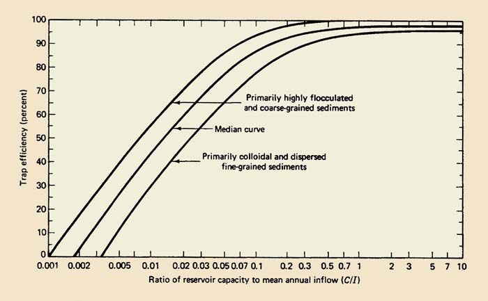 |
Fig. 12 Brune's trap efficiency curves (Brune, 1953).
Brune's method traps a fraction of the sediment yield in the reservoir. Sediment yield (SY) can be assessed in two ways:
- by using an established formula, such as that of Dency and Bolton (1976), or
- by assuming measured and/or postulated [regional] turbidity values.
A sensitivity analysis using three levels of turbidity is performed herein:
- a low value of 1 kg/m3, applicable to the Chancay basin,
- a high value of 5 kg/m3, applicable to the Chira basin.
Note that these turbidity values consider only suspended bed material load, and ostensibly do not include bed load, i.e., the sediment transported by rolling and sliding along the streambed. To account for bed load, the suspended loads are typically multiplied by an appropriate factor. At Puchaca station, located about 4 km upstream of La Calzada, estimates of bedload are about 20% of the suspended load (DEPOLTI, 1998; p. 82).
As a first approximation, a reservoir volume of 64 hm3, including dead storage, is assumed at La Calzada (DEPOLTI, 1998). The drainage area at La Calzada has been calculated at 907.36 km2. The specific weight of sediment deposits (sand-silt mixture) is estimated at 13,000 N/m3. The deposition of primarily coarse-grained sediments is assumed (the worst-case scenario). The mean annual discharge at Puchaca station is 5.539 m3/s for the period 1960-96 (DEPOLTI, 1998). The drainage area at Puchaca has been calculated at 780.1 km2. Using a drainage area ratio, the mean annual discharge at La Calzada is estimated as 6.44 m3/s. Therefore, the mean annual runoff at La Calzada (i.e., the runoff volume divided by the drainage area) is 224 mm.
Table 1 shows the calculations of reservoir design life for a La Leche dam at La Calzada using the Brune method. As an example, the sediment yield for the Chancay river data was calculated as follows:
1.2 × 6.44 m3/s × 1 kg/m3 × 86400 s/d × 365 d/yr
| SY = ___________________________________________________
| 907.36 km2 × 1,000 kg/M.Ton
| |
SY = 269 M.Tons/km2/yr
The results of this table should be viewed with caution, pending additional La Leche sediment data. Sediment discharge data at Puchaca station should provide increased certainty regarding reservoir design life at La Calzada. For this purpose, suspended and bed load measurements should be coupled with a calculation of total sediment discharge by the Modified Einstein Procedure (Colby and Hembree, 1955).
| Table 1. Reservoir design life for La Leche dam at La Calzada.1 | |||||||||||||||||||||||||||||||||||||||||||||
| Method / | Source of data | Sediment yield ( | Time to fill (yr) for the stated percentages
| 20%
| 50%
| 80%
| 100%
| Dendy-Bolton
| United States
| 325
| 58
| 147
| 239
| 317
| 1 kg/m3
| Chancay river
| 269
| 71
| 178
| 289
| 383
| 3 kg/m3
| Jequetepeque river
| 807
| 24
| 59
| 96
| 128
| 5 kg/m3
| Chira river
| 1,345
| 14
| 36
| 58
| 77
|
1 Reservoir volume: 64 hm3;
specific weight of coarse-grain sediments: 13,000 N/m3. | | |||||||||
12. DAM SITING ALTERNATIVES
The two damsites inspected, La Calzada and Calicantro, differ in one important respect: While La Calzada is an instream dam, Calicantro is an offstream dam (Fig. 13). Significantly, the La Calzada site is downstream of a natural widening of the valley of the La Leche river, at the confluence with Cincate Creek (Fig. 10). Likewise, the Calicantro site encloses the Portachuelo de Salas. Portachuelo in Spanish means "an opening between two converging hills," according to the Dictionary of the Royal Spanish Academy (Diccionario de la Real Academia Española).
Judging strictly from a hydrologic standpoint, the site at La Calzada would perform better to attenuate flood flows, while the Calicantro site is expected to have less sediment deposition and a longer design life. Thus, if only one dam is considered, the dam at La Calzada will control floods better than the dam at Calicantro, but will fill up faster with sediments. Conversely, a dam at Calicantro will not control floods as effectively as a dam at La Calzada, but it can store plenty of water and it is likely to last longer.
A way out of this predicament is to consider two dams:
- A primary, smaller flood-control dam at La Calzada, with plenty of retarding-pool storage, a small amount of surcharge storage, and little, if any, active storage, and
- A secondary storage dam at Calicantro, with plenty of active storage, little, if any, retarding pool storage, and a small amount of surcharge storage.
Both sites, La Calzada and Calicantro are judged to be sound from a hydrologic perspective. Both can store substantial amounts of water with reasonable dam heights and lengths. Geologic, geotechnical, environmental, economic, and other factors would have to be examined in detail.
 |
| Fig. 13 Remains on ancient Inca [or pre-Inca] wall at proposed Calicantro damsite. |
13. SUMMARY
The extensive flood plains of the coastal Lambayeque region of northern Peru are an indication of a very active geodynamical condition,
with very high erosion and sediment transport
by local streams. Mass wasting (slides or huaycos) are a result of high precipitation coupled with large gravitational forces in the headwaters
of the La Leche river. In turn, this indicates that sediment transport and deposition may constitute a major factor in design.
The dam being proposed in the La Leche river classifies as a NRCS class (c) dam, where failure could cause loss of life
and serious damage to existing infrastructure. Accordingly, the
return period for design of the emergency spillway should range between 100 years and 10,000 years.
Significantly, the freeboard hydrograph should correspond to the return period of 10,000 years.
Design return periods for longitudinal dikes built downstream of the dam can be taken as 50 to 100 years.
Free-overflow spillways are preferred over closed-conduit spillways, because the latter can clog up with debris
and/or lead to cavitation, both of which may prove to be difficult to control.
A Morning Glory shaft spillway would have to feature a diameter greater than 6 m to guarantee passage of the largest logs.
The possibility of cavitation remains a problem with a Morning Glory spillway.
These reasons indicate that the Morning Glory spillway is not a spillway of choice for the La Leche dam.
Pending detailed modeling, peak flood discharges for the design of the emergency spillway cannot be
ascertained at this time. Experience indicates that the value determined in a previous study,
in connection with the return period of 100 years, is too low for emergency spillway design.
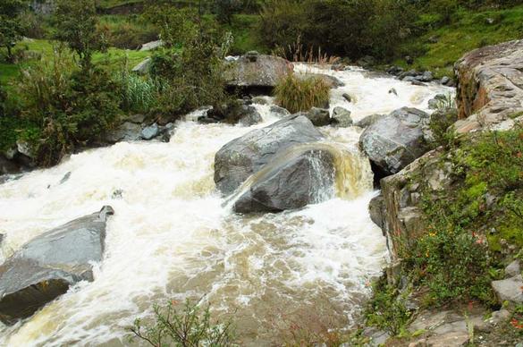
Geomorphological evidence suggests that the La Leche river has carried a lot of sediment in the past.
A lot of sediment can only be transported with very high velocities and correspondingly very high discharges (Colby, 1964) (Fig. 14).
 |
|
Fig. 14 The Moyan river near Tingo, with bed slope So = 0.056.
Note the large size of the bed sediment. |
The deterministic/conceptual approach to rainfall-runoff modeling is judged to be the analytical tool of choice to calculate distributed flood hydrographs in the watershed of the La Leche river. Additional field data of a hydraulic nature is required to run the model under extreme storm and flood scenarios.
A preliminary assessment of reservoir sedimentation indicates that the design life of a proposed reservoir at La Calzada may range from 77 to 383 yr, depending on the estimate of sediment yield (Table 1). Based on regional experience, realistic turbidity values in the range of 1 to 5 kg/m3 are considered. Additional field data on suspended load and bed load, measured for the La Leche river at Puchaca station, is needed to develop more reliable predictions of reservoir sedimentation.
Pending more detailed studies, excessive reservoir sedimentation remains a significant concern to the flood control and water-storage project. To tackle this problem, the possibility of building two dams, one instream, at La Calzada, and another off-stream, at Calicantro, should be examined. Such a scheme will have the following advantages:
- provide adequate instream flood control at La Calzada,
- provide an ample supply of off-stream water storage at Calicantro, and
- reduce sediment deposition in the reservoirs and, consequently, lead to longer design life.
14. REFERENCES
Brune, G. M., 1953. Trap efficiency of reservoirs. Transactions, American Geophysical Union, Vol. 34, No. 3, 407-418.
Colby, B. R., and C. H. Hembree. 1955. Computations of total sediment discharge, Niobrara river near Cody, Nebraska. U.S. Geological Survey Water Supply Paper 1357, Washington, D.C.
Colby, B. R., 1964. Discharge of sands and mean velocity relations in sand-bed streams. U.S. Geological Professional Paper 462-A, Washington, D.C.
Consorcio Salzgitter-Lagesa, 1984. Rehabilitación y reconstrucción de los sistemas de riego y drenaje del valle Chancay-Lambayeque: Estudio de evacuación de avenidas extraordinarias a nivel de factibilidad técnica. Tomo 1: Resumen e investigaciones básicas, marzo.
Creager, W. P., J. D. Justin, y J. Hinds. 1945. Engineering for Dams. Volume 1: General Design, Wiley, New York.
Dendy, F. E., and G. C. Bolton, 1976. Sediment yield-runoff-drainage area relationships in the United States. Journal of Soil and Water Conservation, Vol. 31, No. 6, November-December, 264-266.
DEPOLTI (Dirección Ejecutiva del Proyecto Especial Olmos-Tinajones), 1998. Actualización de la factibilidad tecnico-económica del embalse en el Río La Leche, Chiclayo, Peru, 339 p.
Hydrocoop.org, 2008. Question 79, ICOLD 20th Congress. (accessed 24 February 2008).
Natural Resources Conservation Service, 1985.
Earth dams and reservoirs.
Technical Release No. 60 (TR-60), revised October.
Natural Resources Conservation Service, 1986.
Urban hydrology for small watersheds.
Technical Release No. 55 (TR-55), June.
Perez Becerra, Marcel Arturo, 2006. Estudio hidrológico e hidráulico
en el río La Leche: Generación de las descargas y niveles máximos por avenidas
en la zona del proyecto "Puente Colgante Pítipo." Proyecto Especial Olmos-Tinajones, Gerencia de Desarrollo Tinajones, Mayo.
Ponce, V. M., and F. D. Theurer, 1982. Accuracy criteria in diffusion routing. ASCE Journal of Hydraulic Engineering, Vol. 108, No. 6, June.
Ponce, V. M., 1985. Large basin deterministic hydrology: A case study.
ASCE Journal of Hydraulic Engineering, Vol. 111, No. 9, September.
Ponce, V. M., 1986. Diffusion wave modeling of catchment dynamics. ASCE Journal of Hydraulic Engineering, Vol. 112, No. 8, August.
Ponce, V. M., 1989. Engineering Hydrology, Principles and Practices. Prentice Hall, Englewood Cliffs, New Jersey.
Ponce, V. M., 1991. The kinematic wave controversy. ASCE Journal of Hydraulic Engineering, Vol. 117, No. 4, April.
U.S. Interagency Advisory Committee on Water Data, 1983. Guidelines for determining flood flow frequency. Hydrology Subcommitee, Bulletin
No. 17B, issued 1981, revised 1983, Reston, Virginia.

Fig. 15 Typical hillslopes of the Moyan watershed. Note the steep terrain slopes,
averaging 34%.
| 080411 |