|
PROJECT DESCRIPTION
A. Statement of the Problem/Need/Relevance
The Cañada Joe Bill is a key component of Campo-Tecate Creek, a major tributary of the Tijuana river watershed,
which straddles the U.S.-Mexico border in California and Baja
California. Campo Creek originates in eastern San Diego County and flows into Mexico at A (Fig. 1), where it changes its
name to Cañada Joe Bill.
The latter joins San Pablo Creek at B (Fig. 1) to form Tecate Creek.
West of the city of Tecate, Tecate Creek flows back into the United States and joins Cottonwood Creek in Marron valley, San Diego County,
to form the Tijuana River.
The latter flows back into Mexico, crosses the city of Tijuana, and eventually
flows back into the United States exiting into the Pacific
Ocean at Imperial Beach. The Cañada Joe Bill flows for a distance of 6,268 m,
entirely in Baja California, east of the city of Tecate (Fig. 1).
Due to its close proximity to the United States, the Cañada Joe Bill has strategic binational importance.
It the past few years, the bottom of the canyon has been mined at C (Fig. 1) for sand and gravel, which was exported to the United States
by rail, entering at D. The existing binational railroad line is administered in Mexico
by Ferrocarriles Nacional Mexicanos, and in the United States by
Carrizo Gorge Railway.
The sand-and-gravel mining operation was carried out in the period 1989-2000,
largely without regulation, leaving a scarred landscape with 8-m deep borrow pits
and little resemblance to natural conditions. The current situation is worsened by a flood hazard,
since the existing railroad crosses the creek through an earthen embankment at E (Fig. 1).
The latter, dating back to 1914, is in a state of disrepair and may breach under an infrequent flood.
The postulated breach is likely to cause substantial damage to downstream sites, including the city of Tecate proper.
|
Fig. 1 Location of Cañada Joe Bill showing points of interest.
|
B. Objectives/Outcomes
The study proposes to carry out baseline studies with the aim of restoring Cañada Joe Bill to environmental health.
Five specific objectives are identified:
- A hydrologic study to determine flood flows.
- A hydraulic study to determine flood conveyance.
- A hydroecological study to determine appropriate stream restoration strategies.
- An environmental study to determine the degree of alteration of the microclimate and riparian habitats.
- A sociological study of local stakeholders to assist in the formulate management strategies.
- A geotechnical study for a deterministic evaluation of the safety of the embankment.
- A risk-analysis study for the stochastic evaluation of the safety of the embankment.
- A dam-breach study to assess downstream damages under a postulated embankment failure.
The hydrologic study will determine flood discharges for a wide range of return periods, from 2-yr to 1000-yr.
The following series is envisioned: 2-, 5-, 10-, 20-, 50-, 100-, 200-, 500-, and 1000-yr flood discharges.
Mathematical modeling using HEC-HMS (U.S. Army Corps of Engineers, 2003a)
will be used to calculate the flood discharges.
A geographic information system (GIS) will be used to
support the hydrologic analysis.
The hydraulic study will inventory the current channel conditions throughout the 6.268-km study reach and will work with local stakeholders
to identify and propose the most appropriate solutions for stream restoration. The recent experience with Arroyo Alamar
(Ponce et al. 2004) will be used as an example for the restoration.
The HEC-RAS hydraulic mathematical model (U.S. Army Corps of Engineers, 2003b)
will be used to determine flood stages, depths, and velocities.
The hydroecological study will inventory and classify existing vegetation and examine ways to restore the degraded stream channel to productive stability.
Streambank stabilization with gabions and other noninvasive methods will be considered.
The environmental study will evaluate the degree of alteration of the microclimate and riparian habitats, and it will review the historic data on climatic
conditions prior to and after the alteration.
The sociological study will examine the rural and urban setting in the vicinity of Cañada Joe Bill, will perform a sociodemographic study
of local communities and an identification of local individuals or entities having a stake in the social, economic, institutional and political development of
Cañada Joe Bill.
The geotechnical study will review the history and evolution of the existing railway embankment, the method of construction,
and its usage for the past 90 years. The stability of the embankment will be analyzed under static and flood conditions.
Of particular concern is the ability of the existing outlet to pass the 1000-yr flood without significantly
endangering the structural safety of the embankment.
The risk-analysis study will evaluate the current failure probability of the embankment. The analysis will be qualitative and quantitative, including a risk
simulation provided by the Monte Carlo method, and by developing sensitivity analysis with risk variables. The outcome of the research will offer tangible risk
resul;ts, measuring the impact of a possible embankment failure in terms of losses of life and property.
The dam-breach study will analyze the inundation downstream of the embankment, i.e., in Tecate Creek proper,
following a postulated failure during an infrequent flood.
|
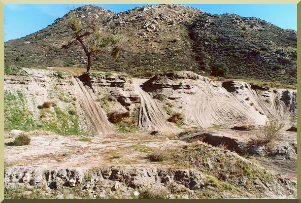
Fig. 2 Closeup of Cañada Joe Bill,
where unregulated sand-and-gravel mining operations have negatively impacted the stream channel and the associated riparian vegetation.
|
C. Research Method/Approach
The research method/approach consists of the following steps:
- Hydrologic watershed modeling using the U.S. Army Corps of Engineers HEC-HMS
to calculate flood discharges for return periods of 2-yr to 1000-yr. The SDSU RAINFLO model will be used for comparison purposes.
The watershed model uses established hydrologic methods to convert rainfall to runoff, using spatially distributed watershed data
encompassing soils, vegetation, terrain topography, stream slopes, channel cross-sectional data, and streambed soils and hydraulic data.
Event precipitation is determined using NOAA National Weather Service methodologies (Ponce, 1989).
Hydrologic abstraction is performed using the standard NRCS runoff curve number method (Ponce and Hawkins, 1996).
Hydrograph generation is performed using the Modified Clark method (Kull and Feldman, 1998).
Stream channel routing is accomplished with the Muskingum-Cunge method (Ponce and Yevyevich, 1978).
- Hydraulic gradually varied flow modeling using the U.S. Army Corps of Engineers HEC-RAS model to determine flood stages, depth, and velocities
throughout the study reach (U.S. Army Corps of Engineers, 2003b). SDSU BACKWATER's model will be used for comparison purposes.
The gradually varied flow model calculates flood stages, depths, and velocities, when presented
with appropriate initial and boundary conditions. The boundary conditions consists of:
(1) a flood discharge upstream, which is determined by the hydrology,
and (2) a stage or flow depth at the downstream point, which is determined
from an assumption of equilibrium (normal) flow downstream of the study reach.
The HEC-RAS model
uses the iterative standard-step method for backwater/drawdown computation (Chow, 1959). This method requires the flood discharge,
detailed cross-sectional data, and the downstream slope. It provides flood depths and stages throughout the study reach.
The cross sections will be determined at appropriate distances, up to 200 m per computational reach (at least 32 cross sections).
- A stream restoration or hydroecological
study to determine the most appropriate way to restore Cañada Joe Bill to its former state of productive stability.
The study includes a vegetation survey, determination of design velocities, streambank stabilization with gabions and other vegetative methods, and
spatial design of the 6.268-km reach.
-
The environmental climatic study will examine historic data on local precipitation and temperature, correlating the variation with known El Niño and
La Niña events. The study will compare aerial photography prior to and after the mining intervention, with aim to ascertain possible cause-and-effect
relations.
-
The sociological study will review the census statistics from 1970 to 2000, to determine the population growth rates in the canyon's vicinity.
Interviews with local actors will be conducted to determine perceptions regarding the future use and development of the canyon.
A stakeholder map will be produced, in which the local actors and institutions will be identified and classified.
A attitudinal survey will be carried out, seeking to determine local perceptions regarding the restoration of Cañada Joe Bill.
- The geotechnical study will consist of a review of the embankment's history and
an analysis of the embankment safety under (a) existing static loads, and (b) infrequent flood conditions.
The embankment's history will be sought in records of the Ferrocarriles
Nacionales Mexicanos. The analysis will be performed using Fellenius' method of slices,
complemented with a finite-element model of slope stability under seepage (GEOSLOPE).
The analysis will include soil sampling and tests to determine permeability and shear strength (direct shear and/or triaxial).
Reservoir routing will be used to model
the filling of the reservoir and possible overtopping of the embankment under an infrequent flood.
The topographic characteristics of the
reservoir and the hydraulic characteristics of the existing outlet structure will be determined prior to reservoir routing.
The study will include recommendations either to increase the safety of the embankment, or to replace the embankment with a safer structure.
-
The risk-analysis study will carry out an impact assessment and a risk assessment, representing both qualitative and quantitative parts of the analysis.
The impact assessment considers several key potential impacts, along with a measure of the potential loss of life resulting from dam failure
(Graham, 1998). Combining all measures of impact allows for a single impact score to be calculated, upon which the level of risk assessment may be determined.
The risk-assesment methodology is based on a failure mode, effect, and criticality analysis approach (CIRIA, 2000). This offers a single framework in which
engineering judgment may be applied through consideration of the various components of the embankment. Components are scored according to their consequence
of failure, likelihood of failure, and confidence. The outcome of the risk-analysis study will outline the current situation of
the embankment in terms of risks and losses caused by a probable failure.
- The dam-breach study will include an analysis of a postulated failure of the railway embankment, following an infrequent flood that fills the reservoir
and overtops the dam. The breach flood hydrograph will be estimated following established empirical techniques (Taher-Shamsi et al., 2003).
The flood hydrograph will be routed downstream, through Tecate Creek, to determine the extent of inundation and the possible damages to
existing urban dwellings on the creek's banks. The National Weather Service DAMBRK model and the dimensionless approach to dam-breach
flood wave propagation (Ponce et al., 2003) will be used for the purposes of routing the dam-breach flood wave through Tecate Creek.
|
Fig. 3 View of the railway embankment showing existing outlet structure or culvert.
|
D. Qualifications/Appropriateness of Research Team
- Victor Miguel Ponce, project coordinator, hydrologist, professor of civil
and environmental engineering, San Diego State University. Dr. Ponce has 36 years of experience
in surface water hydrology, hydroecology, environmental hydrology, and computational hydrology.
He has extensive experience in the United States, Mexico, and Latin America, in academic, research, and consulting roles.
He was the principal investigator of the recently completed SCERP-funded project,
which dealt with the sustainable architecture of Arroyo Alamar.
He is fluent in both English and Spanish, and has in-depth
knowledge and experience of technical and cultural issues on both sides of the border.
- Dr. Julio Valdes, assistant professor of civil and environment engineering, San Diego State University.
Dr. Valdes' expertise is in environmental geomechanics, focusing on novel experimental
applications in seepage and pressing geomechanical problems in Latin America.
He will be responsible for coordinating the geotechnical aspects of the study, which involve the stability of the railroad embankment,
as well as its performance during postulated floods. He is fluent in both English and Spanish, which should facilitate interaction with local
counterparts.
- Mr. Jose Rodriguez Rogero, Associate Director, School of Engineering, Universidad Autonoma de Baja California (UABC), Unidad Tecate.
Mr. Rodriguez will coordinate the work of UABC-Tecate students working on the project.
- Mr. Pablo Andres Rousseau, Associate Director and professor of civil
engineering, School of Engineering, Universidad Autonoma de Baja California (UABC), Unidad Ensenada.
Mr. Rousseau holds and M.S. in hydraulic engineering and has 13 years of experience with
various engineering projects in Baja California.
He will provide expertise in hydraulic and
geotechnical engineering and will coordinate the work of UABC-Ensenada engineering students working on the project.
- Dr. Pedro María Sánchez,
professor of civil engineering, Faculty of Engineering, Universidad Autonoma de Baja California (UABC), Unidad Ensenada.
Dr. María holds a Master of Science degree in Construction Management from the University of Nottingham, United Kingdom,
and a Doctorate in Engineering
(cum laude) in Risk Analysis from the Technische Universität Dresden, Germany. Dr. María
will be in-charge of the risk assessment component of the study.
- Mr. Walter Zuñiga, adjunct professor, Faculty of Sciences, Universidad Autonoma de Baja California (UABC), Unidad Ensenada.
Mr. Zuñiga holds a Masters degree in Ecosystem Management in Arid Zones from the Universidad Autonoma de Baja California.
He recently held the post of Director, Forests and Fauna, Secretaria de Fomento Agropecuario, Baja California.
He has participated in several SCERP-funded research projects dealing with the sustainable management of water and natural resources in the
Ojos Negros valley, Baja California.
Mr. Zúñiga
will provide the academic expertise in ecosystem survey, riparian assessment, and climate and habitat dynamics, and will coordinate the work of the Ensenada team.
- Dr. Guillermo Aramburo, professor, Faculty of Administrative and Social Sciences, Universidad Autonoma de Baja California (UABC), Unidad Ensenada.
Dr. Aramburo has more than 20 years of experience in research and teaching.
As a social scientist, he has participated in several interdisciplinary projects
dealing with technology and society and natural resources.
Recently, he participated in the SCERP-funded project dealing with the sustainable management of
water in the Ojos Negros valley, Baja California.
Dr. Aramburo will formulate the sociological component of the study and
coordinate the work of UABC-Ensenada social-science students working on the project.
-
Chemist Alfredo Angulo, Tecate environmental consultant.
Mr. Angulo is very knowledgeable about the problems facing the Cañada Joe Bill.
Mr. Angulo will coordinate the work of the local consultants and students in Tecate.
-
Mr. Cosme Cázares Burgueño, Cañada Joe Bill stakeholder and organizer.
Mr. Cázares has substantial local experience in the problems facing the Cañada Joe Bill.
He will assist with local logistics and involvement of the local population.
-
Mr. Alberto Castro Garcia, Tijuana hydrological consultant.
Mr. Castro is a recognized expert in the hydrology of the Tijuana river basin.
He has 30 years of experience in hydrological and hydroecological engineering in Tijuana and Baja California,
including the design and construction of several channel-improvement projects in the basin.
Mr. Castro will provide expertise in channel rehabilitation and will assist with field work in the Cañada Joe Bill watershed.
|
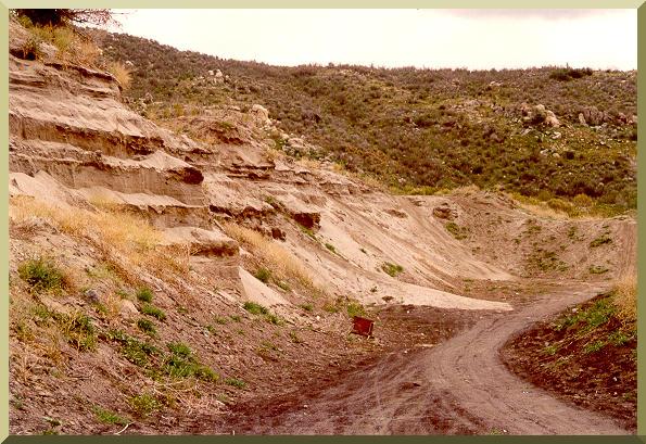
Fig. 4 Another view of the 8-m deep borrow pits in Cañada Joe Bill, the legacy of unregulated sand-and-gravel
mining in the 1990s.
|
E. Schedule
The project duration is 18 months, starting June 1, 2005 and ending November 30, 2006.
A breakdown of tasks and estimated duration is given below.
- Compilation of geographic, topographic, hydrological, hydraulic and historical data: 3 months (June-August 2005).
- Hydrologic, hydraulic, and environmental studies: 3 months (September-November 2005)
- Hydroecologic, demographic, historic and sociological studies: 3 months (December 2005-February 2006)
- Geotechnical and risk-assessment studies: 3 months (March 2006-May 2006)
- Dam-breach study: 3 months (June-August 2006)
- Preparation of draft of final reports, in English, and translation into Spanish, including webposting of reports:
3 months (September-November 2006).
REFERENCES
Chow, V. T. 1959. Open-channel hydraulics. Mc-Graw-Hill, New York.
CIRIA, 2000. Risk assesment and UK reservoirs. Construction Industry Research and Information Association (CIRIA), Report C542.
Graham, W. J. 1998. Estimating loss of life due to dam failure. 18th Annual USCOLD Lecture Series (Lecture Series Title:
Managing the Risks of Dam Project Development, Safety
and Operation), Buffalo, NY, August 10-14.
Kull, D. W., and A. D. Feldman. 1998. Evolution of Clark's unit graph method to spatially distributed runoff.
Journal of Hydrologic Engineering, Vol. 3, No. 1, January.
Ponce, V. M., and V. Yevyevich. 1978. Muskingum-Cunge method with variable parameters. Journal of Hydraulic Engineering,
ASCE, Vol. 104, HY12, 1663-1667.
Ponce. V. M. 1989. Engineering Hydrology, Principles and Practices. Prentice Hall, Englewood Cliffs, New Jersey.
Ponce, V. M. and R. H. Hawkins. 1996. Runoff curve number: Has it reached maturity? Journal of Hydrologic Engineering, ASCE,
Vol. 1, No. 1, 11-19.
Ponce, V. M., A. E. Espinoza, P. Magdaleno, A. Castro, and R. Celis. 2004. Sustainable architecture of Arroyo Alamar, Tijuana, Baja California, Mexico.
http://ponce.sdsu.edu/alamar_sustainable_architecture_final_report.html
Ponce, V. M., A. Taher-Shamsi, and A. V. Shetty. 2003.
Dam-breach flood wave propagation using dimensionless parameters. Journal of Hydraulic Engineering, ASCE, 129(10), 777-782.
Taher-Shamsi, A., A. V. Shetty, and V. M. Ponce. 2003. Embankment dam breaching: Geometry and peak-outflow characteristics. Dam Engineering, XIV(2), August, 73-87.
U.S. Army Corps of Engineers. 2003a. HEC-HMS: Hydrologic Modeling System. Release 2.2.2,
January.
U.S. Army Corps of Engineers. 2003b. HEC-RAS: River Analysis System. Release 3.1.1,
May.
|