A. Statement of the Problem/Need/Relevance
This study proposes to contribute to the ongoing work on the restoration of Tecate Creek, in the 11.1-km reach which goes through the city of Tecate, in Baja California. The study will complement previous work done by Comision Nacional del Agua (CNA), Secretary of Insfrastructure and Urban Development of Baja California (SIDUE), Municipality of Tecate, Roda Arkhos Ingenieria S.C., Huffman and Carpenter, Inc., California State Polytechnic University Studio 606, SDSU's Institute of Regional Studies of the Californias (IRSC), Arizona State University's Department of Landscape Architecture, and Centro de Estudios Urbanos Sociales y Sustentables (CEUSS) of Tijuana.
Tecate Creek originates east of Tecate, at the confluence of Cañada Joe Bill and Arroyo San Pablo. Cañada Joe Bill has its headwaters in eastern San Diego County, in the United States, where it is named Campo Creek. Arroyo San Pablo has its headwaters in Baja California, in the mountains lying east of Tecate. The study encompasses the reach of Tecate Creek, from its upstream point east of Tecate, at the Highway 2 bridge with Cañada Joe Bill, to its downstream point west of Tecate, at the Highway 2 bridge with Tecate Creek (Fig. 1).
 Huffman and Carpenter |
| Fig. 1 Tecate Creek through Tecate, Baja California, Mexico. |
Currently, Tecate Creek is in various stages of planning and development. There is a need to consider the study reach as one entity
and to propose the restoration of the entire reach as one project. The study will consider the stream uses that
are appropriate from the standpoint of hydrology, ecology, urban planning, economy, and aesthetics.
The following stream uses are considered appropriate:
(1) flood mitigation, (2) groundwater replenishment,
(3) land use, (3) recreation, (4) landscaping, (5) habitat for flora and fauna,
(6) preservation and conservation of the riparian corridor,
(7) improvement of water quality, and
(8) compliance with federal stream zoning restrictions.
The relevance of the project is assured. Urban streams should have multipurpose management.
Interdisciplinary synthesis is necessary to assure a holistic view of
restoration of Tecate Creek.
Furthermore, the Tecate Creek watershed is a binational watershed,
with most of its runoff originating on the U.S. side of the border.
Therefore, a holistic and interdisciplinary strategy, in a binational context, is the appropriate level of analysis for Arroyo Tecate.
B. Objectives/Outcomes
This study proposes to study Tecate Creek with the aim to contribute to current work already in place or in progress.
Four specific objectives are identified:
The study will analyze the Tecate Creek watershed, which straddles the border west and east of Tecate (Fig. 2).
Its headwaters are in eastern San Diego County and its mouth is west of Tecate,
at the confluence of Tecate Creek with Cottonwood Creek in Marron valley, San Diego County. As such, the hydrology of Tecate Creek is
heavily dependent on water practices and management on the U.S. side, since about 2/3 of the watershed lies North of the
international boundary.
 Binational Watershed Vision Project |
| Fig. 2 Delineation of the binational Campo-San Pablo-Tecate Creek watershed, with study reach shown between red arrows. |
The hydraulic study will inventory the current channel conditions throughout the 11-km study reach and will work with stakeholders to identify and propose the most appropriate solutions to the channelization, considering the diverse uses of the stream and its diverse conditions (rural, semirural, urban, and industrial). A hydraulic mathematical model (U.S. Army Corps of Engineers HEC-RAS) will be used to determine flood stages, depths, and velocities, using the proposed cross-sections. Relationships between existing and proposed land uses and federal stream zoning restrictions will be taken into account in the hydraulic model.
The stream mechanics study will assess the streambed stability of Tecate Creek, in lieu of recent experience which indicates a degradation of up to 1 m of channel. The extent to which this degradation is due to sand mining upstream of the study reach will be ascertained. Solutions will be proposed to mitigate and reduce the negative effects of stream degradation due to anthropogenic activities.
The low-flow runoff study will analyze the existing runoff data to determine whether low-flow runoff may have been affected by anthropogenic activitites on both sides of the border, particularly in Campo Creek.
C. Research Method/Approach
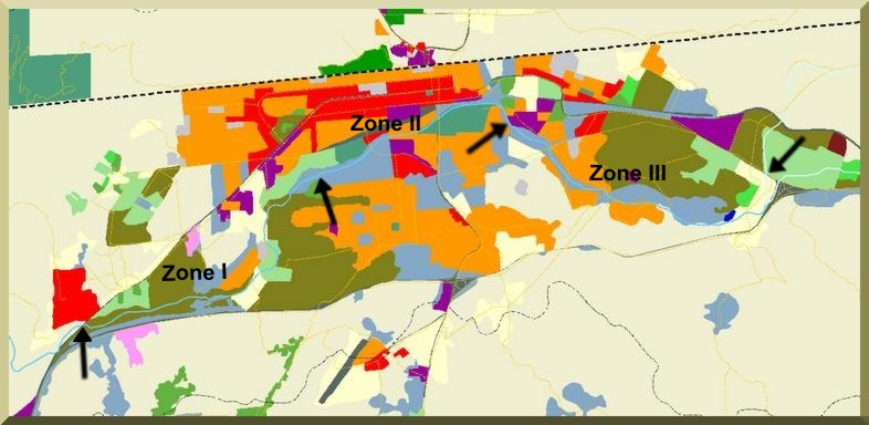
The total length of the study reach is 11.1 km. It encompasses three well-defined management zones, from downstream to upstream: (1) El Rincon, with 4 km, (2) El Centro, with 3 km, and (3) El Descanso, with 4.1 km. (In Fig. 3, black arrows delimit river reaches).
In Zone I (El Rincon), the proposed channel is a composite section, with low flow carrying the 10-yr flow, and full channel section to carry the 1000-yr flow. The flood plain will be considered for alternative uses, including recreation, sports, ecology, landscaping, and aesthetics.
In Zone II (El Centro), the proposed channel is a single trapezoidal section similar to the existing section. The project will explore a way of developing a park in this section, within the existing social and economic constraints.
In Zone III (El Descanso), the proposed channel is similar to that of Zone I, with the same alternative uses.
 Binational Watershed Vision Project |
| Fig. 3 Arrows delimit three distinct management zones within the study reach. |
The research method/approach consists of the following steps:
- Hydrologic watershed modeling using the U.S. Army Corps of Engineers HEC-HMS
to calculate flood discharges for return periods of 2-yr to 1000-yr. The SDSU RAINFLO model will be used for comparison purposes.
The watershed model uses established hydrologic methods to convert rainfall to runoff, using spatially distributed watershed data
encompassing soils, vegetation, terrain topography, stream slopes, channel cross-sectional data, and streambed soils and hydraulic data.
Event precipitation is determined using NOAA National Weather Service methodologies (Ponce, 1989).
Hydrologic abstraction is performed using the standard NRCS runoff curve number method (Ponce and Hawkins, 1996).
Hydrograph generation is performed using the Modified Clark method (Kull and Feldman, 1998).
Stream channel routing is accomplished with the Muskingum-Cunge method (Ponce and Yevyevich, 1978).
- Hydraulic gradually varied flow modeling using the U.S. Army Corps of Engineers HEC-RAS model to determine flood stages, depth, and velocities
throughout the study reach. SDSU BACKWATER's model will be used for comparison purposes.
The gradually varied flow model calculates flood stages, depths, and velocities, when presented
with appropriate initial and boundary conditions. The boundary conditions consists of:
(1) a flood discharge usptream, which is determined by the hydrology,
and (2) a stage or flow depth at the downstream point, which is determined
from an assumption of equilibrium (normal) flow downstream of the study reach.
The gradually varied flow model (HEC-RAS)
uses the iterative standard-step method for backwater/drawdown computation (Chow, 1959). This method requires the flood discharge,
detailed cross-sectional data, and the downstream slope. It provides flood depths and stages throughout the study reach.
The cross sections will be determined at appropriate distances, up to 100 m per computational reach (at least 111 cross sections)
The research team will work with local stakeholders
(Municipality of Tecate and Secretaria de Infraestructura y Desarrollo Urbano de Baja California SIDUE)
to ensure that the hydraulic study is fully compatible with the architectural and landscape design of the channel restoration.
- Stream mechanics modeling using SDSU's MODELRIVER (HEC-6 standard) to determine streambed stability.
This model simulates the transport of water and sediment in a river reach, when presented with appropriate initial and boundary
conditions. The equations solved are the following: (1) water continuity, (2) water motion, (3) sediment continuity, and (4)
sediment motion. The sediment motion (bed material transport) equation is the Colby method (Colby, 1964; Ponce 1989), suitable for
alluvial rivers with medium to coarse sand in the channel bed.
The extent to which channel bed degradation could be linked to anthropogenic causes (sand mining) upstream of the
study reach will be modeled.
The model will require detailed sedimentological data (grain size analysis, specific gravity).
Bed material field sampling and laboratory analysis will be required. Up to ten (10) bed material samples will be
extracted and tested in the SDSU Geotechnical Laboratory.
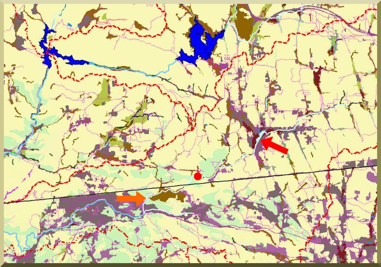
- The low-flow runoff study will examine the surface runoff data in Tecate and Campo creeks Gaging station data will be compiled and analyzed to determine runoff trends. The U.S. gaging station at Campo Creek (1988-2003) will be used for this purpose. The question to be answered is whether the time series will reveal a hydrologic impact of anthropogenic runoff retention and detention in Campo Creek (Fig. 4) on the downstream flow. A related question is what percentage of the Campo Creek streamflow entering Mexico is being abstracted by channel transmission losses in Cañada Joe Bill (Fig. 4) before it has a chance to flow into Tecate Creek. Following intensive sand mining, the existing degraded conditions (a widened and deeply incised canyon) in Cañada Joe Bill may well have a substantial role in abstracting streamflows entering Mexico from the U.S. Watershed modeling using SDSU's RAINFLO will be applied to Cañada Joe Bill to determine prior- and post-sandmining channel trasmission losses in the 1-km reach of Cañada Joe Bill (Ponce, 2001).
 Binational Watershed Vision Project |
| Fig. 4 Campo Creek, in California, showing runoff retention and detention (red arrow), and Cañada Joe Bill, in Baja California, where substantial channel transmission losses may be taking place (orange arrow); USGS gaging station shown as red dot. |
The research team will assemble relevant geographic, topographic, hydrologic, soil, vegetation, hydraulic, riparian, urban, architectural and landscape design data to provide disciplinary and interdisciplinary synthesis to contribute to the Tecate Creek Corridor restoration. The research team will coordinate and work closely with other consultants and local stakeholders to ensure that the research results are relevant and meaningful to the proposed stream/river restoration.
 Victor Miguel Ponce |
| Fig. 5 Closeup of Cañada Joe Bill, in Baja California, where substantial channel transmission losses may be taking place. |
D. Qualifications/Appropriateness of Research Team
E. Schedule
The project duration is 18 months, starting June 1, 2004 and ending November 30, 2005.
A breakdown of tasks and estimated duration is given below.
REFERENCES
Chow, V. T. 1959. Open-channel hydraulics. Mc-Graw-Hill, New York.
Colby, B. R. 1964. Discharge of sand and mean velocity relations in sand-bed streams. U.S. Geological Survey Professional Paper 462-A,
Washington, D.C.
Comisión Nacional del Agua, México, 1995. Proyecto de canalización del Río Tecate.
California State Polytechnic University, Pomona, Studio 606, 2003. A framework for an urban river environment: Tecate, Mexico,
May.
Huffman and Carpenter Inc. 2002. Initial feasibility report for the Tecate river restoration project.
Kull, D. W., and A. D. Feldman. 1998. Evolution of Clark's unit graph method to spatially distributed runoff.
Journal of Hydrologic Engineering, Vol. 3, No. 1, January.
Ponce, V. M., and V. Yevyevich. 1978. Muskingum-Cunge method with variable parameters. Journal of Hydraulic Engineering,
ASCE, Vol. 104, HY12, 1663-1667.
Ponce. V. M. 1989. Engineering Hydrology, Principles and Practices. Prentice Hall, Englewood Cliffs, New Jersey.
Ponce, V. M. and R. H. Hawkins. 1996. Runoff curve number: Has it reached maturity? Journal of Hydrologic Engineering, ASCE,
Vol. 1, No. 1, 11-19.
Ponce, V. M. 2001. Flood hydrology of the Binational Cottonwood Creek - Arroyo Alamar, California
and Baja California.
Direccion de Ordenamiento Territorial, Secretaría
de Infraestructura y Desarrollo Urbano (SIDUE), Estado de Baja California. 2003. Consideraciones técnicas
para la seguridad del Río Tecate y punto de partida para la aplicación de acciones de conservación,
rescate y aprovechamiento de la zona federal, Noviembre.
U.S. Army Corps of Engineers. 2003. HEC-HMS: Hydrologic Modeling System. Release 2.2.2,
January.
U.S. Army Corps of Engineers. 2003. HEC-RAS: River Analysis System. Release 3.1.1,
May.