|
A. Statement of the Problem/Need/Relevance The Municipality of Tijuana has recently approved the document entitled "Directrices Generales de Desarrollo para la Zona del Arroyo Alamar," (Master Plan for the Development of Arroyo Alamar) (Honorable XVII Ayuntamiento de Tijuana, 2002). This document is a comprehensive planning tool for the development of Arroyo Alamar, prepared after appropriate consultation with federal, state, and local agencies. The planned development and rehabilitation of Arroyo Alamar considers a host of features, including land-use zoning (agriculture, recreation, commerce and housing), groundwater replenishment, preservation of the riparian corridor, flood mitigation, enhancement of green space, and improvements in public health. The Arroyo Alamar is located within the Tijuana River basin, northeast of the city of Tijuana. With a length of 10 km inside the urban area, the Arroyo Alamar constitutes an important area of groundwater recharge in the region. Ponce (2001) has estimated that the Arroyo Alamar contributes 22% of the water pumped annually from aquifers in the Tijuana River basin. The city of Tijuana pumps a monthly volume of 146,000 m3 from 30 wells located in the Tijuana river valley, including Arroyo Alamar. |
|
|
| Instituto Municipal de Planeación |
| Fig. 1 Location of Arroyo Alamar, Tijuana. |
|
The Arroyo Alamar watershed has 1387 km2, 86% of which are located in California, and the remainder in Baja California. In California, the stream is known as Cottonwood Creek, which is regulated by the city of San Diego's Morena and Barrett dams. The flood hydrology of the combined Cottonwood Creek/Arroyo Alamar has been recently studied by Ponce (2001), who determined flood peaks for 2- to 1000-yr return periods. The Arroyo Alamar is a riparian corridor which has been subject to encroachment by the city of Tijuana in the past 20 years. Largely unplanned uses, including agriculture, light industry, and make-shift urban dwellings dot the Alamar landscape. Another disturbing use is the illegal dumping of trash, which constitutes a public health hazard. The risk of flooding and associated losses is ever present, since the contributing watershed is rather large, and most of it remains uncontrolled. A current SCERP (2002-2003) study is entitled "Hydroecological characterization of Arroyo Alamar." The study is developing hydroecological relations for the Arroyo Alamar. Specifically, the project will determine the channel properties that are compatible with hydroecological functions. This includes cross-sectional channel design, flood levels, depths and velocities, bank protection, and the preservation of the riparian corridor. There is an urgent need to develop a sustainable architectural and landscape design of Arroyo Alamar. The holistic design of the river should strive to comply with the Master Plan. The sustainable architecture consists of the spatial design of the 10-km reach of Arroyo Alamar, seeking compatibility of perceived hydroecological functions and planned uses. The hydroecological functions include groundwater replenishment, preservation of the riparian corridor, and flood mitigation. The planned uses are recreation and enhancement of green areas, including landscaping and aesthetics. Recreation includes pedestrian walkways, exercise tracks, children playgrounds, soccer fields, tennis/basketball courts, rollerskating and skateboard parks, and golf courses. Sustainable river architecture is a novel concept in the framework of stream rehabilitation. It comprises the hydrological, ecological, geomorphological, socioeconomic, and other aspects of the space and seeks to provide a sustainable habitat where plants, animals, and human beings can coexist in harmony. To accomplish this objective, we have assembled a binational, interdisciplinary, and multi-institutional team of experts, comprising hydrologists, biologists, architects, urban planners, and engineers from both sides of the border. The proposed research project will maintain close contacts with Tijuana's Secretaria de Desarrollo Urbano (Secretary of Urban Development) and the Instituto Municipal de Planeacion (Municipal Planning Institute). The project is properly contained within the federal regulations for development of the watercourses of Mexico. A sustainable and socially meaningful project of this type may be subject to replication in other streams which straddle the border. Once executed, the project will convert the Arroyo Alamar into a planned river park that the citizens of the Alamar and Tijuana are certain to be proud of. The sustainable architectural characterization will be coupled with a GIS system of the Arroyo Alamar. The GIS system will be a specialized geographical data base of the current status of the Alamar. Together with the proposed river architecture and the associated GIS system to manage it effectively, we propose to plan and execute a Citizens Involvement Program (CIP) to inform and persuade local stakeholders of the varied and multiple benefits of the project. Local support is deemed necessary for this project, where the proposed development will directly impact a host of parties that currently inhabit the Arroyo Alamar and environs. Thorough understanding of the complex socioeconomic issues are necessary to carry out this project to its successful completion. B. Objectives/Outcomes This study proposes to carry out a sustainable architectural design of Arroyo Alamar. The specific objectives are the following:
The project will benefit the city of Tijuana by empowering it to effect the rehabilitation of Arroyo Alamar with a river architecture design that is fully responsive to the hydroecological requirements. The success of the project will be measured by the extent to which it improves the quality of life of the Arroyo Alamar and Tijuana residents. Perceived direct benefits are the maintenance of natural environmental services (groundwater replenishment and preservation of riparian corridor), effective flood mitigation, enhanced public health, and increased recreational opportunities.
C. Research Method/Approach The research method/approach consists of the following steps:
The topographic data will be supplied by the city of Tijuana to scale 1:2000. The project team will meet with Tijuana city officials to establish the location of diverse land uses within the project site. Mexican hydrological practice, as determined by the Comisión Nacional del Agua (CNA), indicates that the design frequency to establish the federal zone is 10 yr, and the design frequency for the channelization in a predominantly urban area such as the Alamar is 1000 yr. Existing land-use information will be assembled, including existing and planned developments, riparian, agriculture, industry, sand mining, recreation, tourism, commerce and housing. The research team will coordinate and cooperate with the Arizona State University (ASU) Alamar research team. The ASU team has developed a set of thematic maps identifying sensitivity areas for habitat, groundwater recharge, soil erosion, scenic value, and restoration potential. This and other related information to be developed as part of future studies will be used in the sustainable architectural design. The developed GIS will define spatial management units. These units will contain socioeconomic data, such as income, years of schooling, quality of housing, characteristics of the infrastructure, and environment. The latter will specify biological species, soil types, terrain slopes, and hydrologic information (flood frequency levels). The GIS will make possible the following:
The sustainable architectural design will encompass the entire length of the Arroyo Alamar, from its upstream end at the bridge at Cañon del Padre to its downstream end 10 km downstream, to connect with the Second Phase of Rio Tijuana. This includes three distinct zones (Fig. 2):
Zone A is currently a mix of agricultural and industrial uses; Zones B and C are primarily make-shift urban.
Current conditions are shown in Fig. 3. Garbage dumps and irregular settlements dot the Arroyo Alamar landscape
(Note the sign on the third photo--Zone C: Danger / High risk of flooding / Invasions are ilegal).
|
|
|
|
The research team will review the Atoyac river rehabilitation project,
in Oaxaca, Mexico, where the concept of river architecture,
including groundwater replenishment, preservation of
riparian vegetation, flood mitigation, landscaping, and recreation was successfully implemented in 1996.
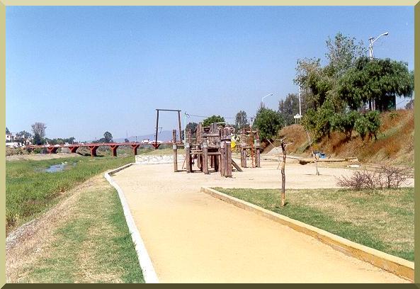
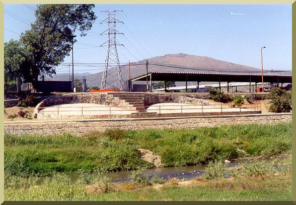
Present conditions in the Atoyac river, showing a diversity of recreation features,
are shown in Fig. 4.
The research team wil also review the design of the
Rio Santa Catarina, in Monterrey, Mexico,
another successful project of river architecture.
Insights gained by the review of these two projects will help in the formulation of the sustainable architectural design
of the Alamar river.
|
|
| Fig. 4 Atoyac river architecture, in Oaxaca, Mexico (November 2002). |
|
D. Qualifications/Appropriateness of Research Team
E. Schedule The project duration is 15 months, starting June 1, 2003 and ending August 31, 2004. A breakdown of tasks and estimated duration is given below.
The project team will meet on a bimonthly basis with Tijuana city officials, to provide a progress report and coordinate the execution of the field work.
REFERENCES Honorable XVII Ayuntamiento de Tijuana, B.C. 2002. Directrices generales de desarrollo para la zona del "Arroyo Alamar" de la ciudad de Tijuana, B.C." Ponce, V. M. 2001. Flood hydrology of the Binational Cottonwood Creek - Arroyo Alamar, California and Baja California. http://alamar.sdsu.edu Ponce, V. M. 2002. Rehabilitación del Río Atoyac, Ciudad de Oaxaca, México: Pictorial. http://ponce.sdsu.edu/rioatoyac.php |