A. Statement of the Problem/Need/Relevance
The Instituto Municipal de Planeación (IMPlan-Tijuana) has among its current projects the rehabilitation of Arroyo Alamar, a tributary of the Tijuana river. This project will satisfy a host of urban-planning needs, such as the preservation of riparian areas, flood management, planned land use, recreation, landscaping, a green corridor, replenishment of groundwater, improvement of water quality, and compliance with federal stream zoning restrictions.
The project encompasses the 10-km reach of Arroyo Alamar, located between the bridge on the toll road to Tecate, and the channelized reach near the confluence with the Tijuana river. The objective of the project is to rehabilitate the Arroyo Alamar and its flood plain to encourage planned land use and preserve primary hydroecological functions.
IMPlan has developed a preliminary land-use plan which includes a diversity of uses such as agricultural, industrial, urban, recreation, and flood prevention and mitigation. A hydrological study to determine design flood magnitudes has been completed by the Principal Investigator Dr. Victor M. Ponce, in a FY2000 SCERP-funded project. A summary of the results of this project is appended to this proposal. For return periods of 2, 5, 10, 25, 50, 100, 200, 500, and 1000 years, the flood discharges are: 280, 530, 680, 930, 1140, 1310, 1420, 1600, and 1720 m3 s-1, respectively.
There is an urgent need to continue the hydrological study to its next logical step, i.e., to develop a hydroecological characterization aimed at determining flood levels that are congruent with the proposed land uses. This must include close consultation with cognizant federal agencies to determine applicable stream zoning restrictions.
Tijuana's city planners envision the rehabilitation of Arroyo Alamar to have the essential character of a green corridor, with multiple land uses in tune with the primary flood-mitigation, aquifer-replenishment, and riparian-habitat functions. In a city with very few large tracts of greenery, the hydroecological rehabilitation of Arroyo Alamar is a highly desirable project. The concrete-channel alternative used in the development of the First and Second Phases of the Rio Tijuana is no longer considered viable, given its marked negative impacts of the landscape and environment. Thus, this project will assist IMPlan in furthering their goals of rehabilitating the Arroyo Alamar with an ecologically sound approach.
B. Objectives/Outcomes
This study proposes to carry out a hydroecological characterization of Arroyo Alamar. The specific objectives are the following:
- To determine the channel properties that are compatible with primary hydrological and
ecological functions. These include the cross-sectional geometry, longitudinal slopes,
grade control features, bank protection, and percolation to ground water.
The study will encompass the preservation and enhancement of existing riparian corridors,
the rehabilitation of degraded riparian areas where warranted,
and the selection of alternative land uses.
- The determination of the flood frequencies
to be implemented in the characterization,
and the hydraulic design of the hydroecological channel
to convey the selected flood flows. This phase of the study will be performed in close
consultation with the cognizant federal agency (Comisión Nacional del Agua)
and the executing agency (IMPlan).
C. Research Method/Approach
The research method/approach consists of the following steps:
- Assemble topographic information in suitable form. IMPlan is currently
preparing a detailed topographic survey of the project site.
Detailed topographic maps are needed to extract cross-sectional data required for
the characterization.
- Assemble land-use information, including existing and planned developments,
riparian, agriculture, industry, recreation, tourism, and other area. Coordinate with
the ASU (Arizona State University) SCERP-funded Alamar research team to use the vegetative and other
data from their pilot studies to enhance the hydroecological characterization of Arroyo Alamar. Evaluate the benefits
to water quality provided by the hydroecological channel.
- Together with IMPlan, to schedule and carry out consultation meetings with officials of
the Comisión Nacional del Agua, in Mexicali and Mexico City,
to establish appropriate flood frequencies to be used in the design.
- To perform the
hydrological and ecological design of the rehabilitated channel and its flood plain.
This includes the modeling of flood flows using the standard
U.S. Army Corps of Engineers HEC-RAS (Hydrologic Engineering
Center - River Analysis System) model, Version 3.0.
For comparison purposes, the gradually varied flow model (BACKWATER)
developed by the Principal Investigator Dr. Victor M. Ponce will be used.
The ecological design includes the selection and establishment
of riparian, agriculture, industry, recreation, and other multi-purpose areas within the project site.
- To establish the need, where appropriate, to stabilize the stream channel by means of bank protection, grade control, and other suitable means, with the objetive of sustaining the design flood flows; and to develop designs of such features.
The topographic data will be supplied by IMPlan to scale 1:2000. The project team will meet with IMPlan officials and ASU researchers to establish the location of diverse land uses within the project site. For this purpose, IMPlan has developed a preliminary land use plan to be used as a baseline for the characterization (Fig. 1). The project area has been delimited as 1380 ha and the federal (restricted stream) zone as 326 ha.
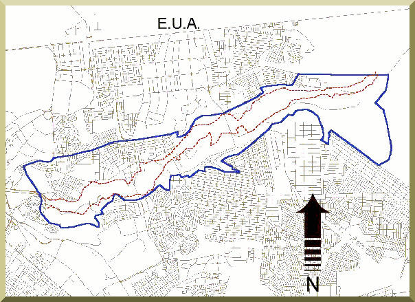 Instituto Municipal de Planeación |
| Fig. 1 Project site along the northeastern portion of the city of Tijuana; outside (solid) lines delimit project area; inside lines delimit federal zone. |
Preliminary appraisal based on Mexican hydrological practice indicates that the federal frequency should be at least 10 yr, and the project design frequency should be between 50 and 200 yr. The characterization will encompass the entire length of the Arroyo Alamar rehabilitation project, from its upstream end at the bridge over the Tecate toll road to its downstream end about 10 km downstream, to connect with the Second Phase of the Rio Tijuana. This includes three distinct sections:
- From the bridge at the Tecate toll road to the bridge at Boulevard Héctor Terán Terán.
- From the bridge at Boulevard Teran Teran to the bridge at Boulevard Manuel J. Clouthier.
- From the bridge at Boulevard Clouthier to the end of the Second Phase of the Rio Tijuana.
The hydraulic modeling will be performed using 100 cross sections, each every 100 m. This is necessary to ensure stability and accuracy of the backwater computation, which will enable a precise delineation of the design flood stages.
The hydroecological characterization will be based on the principle of mixed use of the stream channel, including riparian, agriculture, light industry, recreation, tourism, and water quality management. The cross-sectional design that reflects the mixed uses and different flooding risks associated with those uses. A three-zone or three-frequency compound channel is envisioned, with federal, soft-use, and intermediate-use zones. The federal zone is left to convey the regulation flood (10-yr frequency); the soft-use zone will house riparian, agriculture, recreation, and ecotourism zones (50-yr frequency); the intermediate-use zone will house light industry (200-yr frequency). The design will learn from the recent experience with the Atoyac river, in Oaxaca, where the concept of mixed use has been successfully implemented (Fig 2).
 Instituto Tecnológico de Oaxaca |
| Fig. 2 Rehabilitation of the Atoyac river, Oaxaca, Mexico. |
D. Qualifications/Appropriateness of Research Team
- Dr. Victor Miguel Ponce, project coordinator, hydrologist, Professor of Civil
and Environmental engineering, San Diego State University. Dr. Ponce has 28 years of experience
in surface and groundwater hydrology, environmental hydrology, and hydroecology.
He has extensive experience in the United States, Mexico, and Latin America, in both consulting and research roles.
He was the Principal Investigator of the recently completed SCERP-funded project,
which dealt with the hydrology of the Binational Cottonwood Creek - Arroyo Alamar.
He is fluent in both English and Spanish, and can bring to
bear his knowledge of technical and cultural issues on both sides of the border.
-
Mr. Alberto Castro Garcia, Tijuana hydrological consultant.
Mr. Castro is a recognized expert in the hydrology of the Tijuana river basin.
He has 30 years of experience in hydrological and hydroecological engineering in Tijuana and Baja California,
including the design and construction of several channel-improvement projects in the basin.
He has been a consultant for IMPlan for the past three years,
and has extensive familiarity with the Alamar project and its hydroecological features.
Mr. Castro will provide the local expertise in Tijuana and will assist in coordinating meetings with local officials.
-
Mr. Ampar Vipinchandra Shetty, hydrologist, National Institute of Hydrology, India,
currently pursuing a Ph.D. at San Diego State University under the direction of Dr. Victor M. Ponce.
Mr. Shetty has an M.S. in Hydrology (1987) from University College Galway (UCG), Ireland.
He brings to the project extensive experience in hydrological design, including channels and appurtenances.
Mr. Shetty will assist the Principal Investigator and will perform the detailed modeling.
- Dr. Jose Delgadillo Rodriguez, professor of biology, Facultad de Ciencias, Universidad Autonoma de Baja California, Unidad Ensenada. Dr. Delgadillo has 25 years of experience in vegetation science, including the maintenance and enhancement of riparian areas. Dr. Delgadillo will serve as a consultant in matters related to riparian enhancement and restoration.
E. Schedule
The project duration is 15 months, starting June 1, 2002 and ending August 31, 2003. A breakdown of tasks and estimated duration is given below.
- Compilation and analysis of topographic, hydrological, vegetative, and land-use data: 3 months (June-August 2002).
- Consultation with cognizant parties to determine the design floods: 3 months (September-November 2002).
- Hydroecological characterization of Arroyo Alamar, including identification of land uses and modeling: 6 months (December 2002- May 2003).
- Preparation of draft and final reports, in English, and translation into Spanish, including webposting of reports: 3 months (June-August 2003).
The project team will meet on a monthly basis with IMPlan officials in Tijuana, to provide a progress report and coordinate the execution of the field and laboratory work.
REFERENCES
Barnes, H. A., 1967. Roughness characteristics of natural channels U. S. Geological Survey Water-Supply Paper 1849, Washington, D.C.
Comisión Nacional del Agua, 1993. Cuenca Arroyo El Alamar, Tijuana, B.C., Estudio Hidrológico. Gerencia Estatal de Baja California, Subgerencia de Administración del Agua, Ensenada, B.C.
Comisión Nacional del Agua, 1994. Datos hidrológicos, Arroyo Alamar, Tijuana. Gerencia Regional de la Península de Baja California, Subgerencia Regional Técnica, Mexicali, B.C.
Chow, V. T. 1959. Open-channel hydraulics. McGraw-Hill, New York.
Instituto Municipal de Planeación, 1999. Propuesta Alternativa de Desarrollo para la Cuenca del Arroyo Alamar. City of Tijuana, Baja California, Mexico, November.
Ponce, V. M. 2001. Flood hydrology of the Binational Cottonwood Creek - Arroyo Alamar, California and Baja California. http://alamar.sdsu.edu
Ponce. V. M. Gradually varied flow model (BACKWATER). http://ponce.sdsu.edu/backwaterform.html
U.S. Army Corps of Engineers. 2001. HEC-RAS: River Analysis System. Release 3.0, January.