|
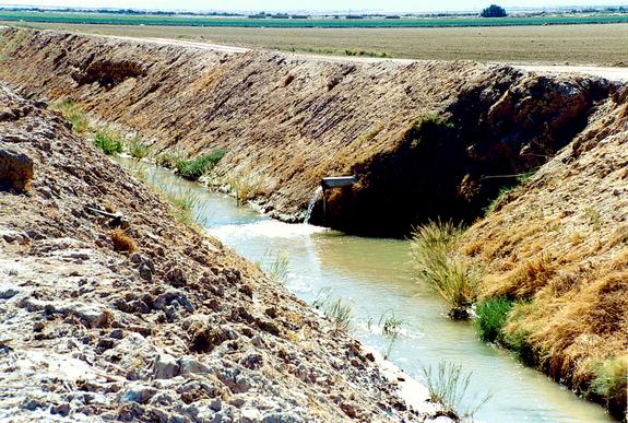
Agricultural drain in the Imperial valley, California,
the source of the Salton Sea.
THE SALTON SEA: AN ASSESSMENT
The Salton Sea is the largest lake in California, encompassing 378 square miles in Imperial and Riverside counties, in the Southeastern edge of the state.
Strictly speaking, it is not a sea but a geological depression tucked between mountain ranges and lying below sea level.
In the past century, it has been used as the repository for agricultural wastewaters originating in the Imperial valley, which neighbors the Salton Sea to the South.
The sea is slowly deteriorating for its other uses, and the question has been raised: What to do about this?
Should the sea, effectively a sink for wastewaters, be left to degrade slowly with time?
Or, should it be restored to an optimal or target salinity level?
This document explores the various issues surrounding the controversy.
ORIGIN
The geologic depression where the Salton Sea is located was caused over geologic time by mountain uplift and associated subsidence.
As the mountains in the vicinity grew, subsidence of the Earth's mantle led to the depression, with its lowest point at -278 ft below mean sea level.
The neighboring Colorado river, in its quest to reach the ocean, eroded and transported billions of tons of silt towards its mouth at the Gulf of California.
Over geologic time, it formed, near its estuary, the natural levees which isolated the Salton depression, protecting it from the eventual incursions of the river to the East and the ocean to the South.
Any water reaching the depression, either from local runoff or from the Colorado river during major floods, eventually evaporated, leaving a dry lake bed most of the time.
Runoff in the depression was endorheic, meaning that the lowest point, to which runoff tends naturally, is not at the basin's perimeter, but rather somewhere in the middle.
Thus, the Salton depression and its status prior to human intervention was closely linked to the prevailing geology and geomorphology, and to its peculiar geographical location, near the mouth of a great river, the Colorado, which historically has carried a lot of sediment.
HISTORY
In 1905, a diversion was engineered in the Colorado river, in Baja California, Mexico, a few miles South of Yuma, Arizona, for the purpose of conveying water to irrigate lands in the Imperial valley, in Imperial County, California, located to the Northwest.
The diversion, of inadequate size and built with temporary structures, went sour, and the Colorado river changed course, first flowing West and then North in the direction of the Salton depression.
By the time the river was brought under control, in 1907, the water had filled the depression to the level of -195 ft, effectively creating the Salton Sea.
Left on its own, the water in the sea would have eventually evaporated.
This is because the region's mean annual precipitation is only about 2.3 inches, while the mean annual evaporation is 70 inches.
By the early 1920's, the sea had reached a record low of -250 ft.
However, in 1928, Congress acted to designate the lands within the Salton basin below -220 ft as storage for wastes and seepage water from irrigated lands in Imperial valley.
Since then, the sea has been used mainly as a repository for agricultural wastewaters, with the water level rising gradually to its present -227 ft.
The average depth of the sea is about 30 ft, and the maximum is 51 ft.
SALINITY
In 1907, at the time of the sea's origination, the average salinity of the water was about 3,500 parts per million.
With the agricultural wastewaters came a diversity of solids, mostly salt ions, which contributed to the lake's increase in salinity.
The lake is currently close to hydrologic equilibrium, with inflows closely matching outflows through evaporation.
The solid ions, however, among them, notably, sodium (Na+) and chloride (Cl-), are left behind to accumulate in the lake profile.
The high solubility of sodium chloride assures that, left on its own, the sea's salinity will continue to increase with time.
Levels of salinity have presently reached about 45,000 parts per million, making the sea about 30% saltier than the ocean.
The origin of the salts and other mineral constituents entering the Salton Sea can be traced to four sources:
- The salt already present in the soil profile (local geologic salt),
- The salt brought in with the irrigation water (imported geologic salt),
- The salt produced by the weathering of the soil minerals as a result of irrigation (local anthropogenic salt), and
- The salt leached from the soil profile because of excessive fertilization (imported anthropogenic salt).
FISHERIES AND RECREATION
Initially, the Salton Sea supported a community of freshwater fishes that came with the Colorado river water.
As salinity increased through the years, the original freshwater fish disappeared.
Between 1929 and 1956, the California Department of Fish and Game made numerous transplants of both fish and invertebrates with the aim of developing a sport fishery in the sea.
Of the numerous sport-fishery species intentionally transplanted, only three, corvina, sargo, and bairdella, survived.
Laboratory research has shown that spawning of corvina does not take place at salinity levels exceeding 45,000 parts per million.
Other recreation activities at the sea include boating, water skiing, hiking, and bird watching.
WILDLIFE
The impact of increased salinity is not limited to fisheries resources.
It is also likely to affect wildlife resources, since the Salton Sea is in the Pacific Flyway, which sustains numerous migratory bird species, particularly the waterbirds.
The latter represent the higher trophic levels of food chains in the Salton Sea and surrounding areas.
Nearly 400 bird species have been observed at the sea, about half of the 900 bird species known to exist in the North American continent.
STATUS
As it currently stands, the Salton Sea serves the following three purposes:
- A convenient repository for agricultural wastewaters,
- A resource for fisheries and outdoor recreation, and
- A resource for wildlife.
Since the natural state of the sea is a dry lake bed, all three of these uses are artificial.
The first use is a logical consequence of extensive irrigation in the Imperial valley, which results in substantial economic benefit to the local growers and, by extension, to the State of California.
The second use admittedly would not exist if it were not for the first, and the existence of the third use is related to the second.
Thus, in the Salton Sea, the needs of the agricultural enterprise are closely intertwined with society's perceived needs for recreation and wildlife.
In 2003, a decision was made to effect an annual transfer of 200,000 acre-feet of water from the Imperial valley to San Diego County, for urban use.
After 2019, with the transfer in full force,
the reduced inflows to the sea will produce a shift in the hydrologic equilibrium to a lower sea level.
WHAT TO DO?
Left on its own, the lake's salinity will continue to increase gradually, eventually impairing its other uses.
The fish will disappear, and this will affect the wildlife.
Only one use will remain: that of serving as a dump for the wastewaters of the agricultural enterprise.
The veritable brew of chemical constituents and elements, including selenium, will have to be monitored carefully to avoid a repetition of the Kesterton Reservoir incident in California's San Joaquin valley, in the 1980's.
In this case, a much smaller human-made lake, also a repository for agricultural wastewaters, was used by birds who eventually became sick and perished from ingesting large quantities of selenium and other toxics.
The latter, brought in in trace amounts with the water, had accumulated to concentrations that became lethal to the unsuspecting birds.
RESTORATION
Barring no action, the alternative is to restore the sea so that it can continue to serve its other purposes, i.e., recreation and wildlife.
In principle, this requires reducing the salinity of the Salton Sea to a level comparable to that of the ocean.
This undertaking is technologically complex, energy-intensive and costly, with the price tag likely to run into the billions of dollars.
For one thing, extracting sodium chloride out of water is at best a difficult proposition.
The situation is complicated by the fact that the salts of the Salton Sea are of many types.
Sodium and chloride constitute only about 60% of the salt ions, so evaporation will produce a mix of salt ions that will be difficult to commercialize without additional work.
To this date, no restoration strategy is without its pitfalls.
A leading proposal is to accumulate the solids in a smaller, diked portion of the sea, while assuring the health of the remaining larger portion.
However, this solution is unsustainable because the solids are not being physically removed from the system, so future generations will still have to cope with the additional solids.
STRATEGY
The first step in a comprehensive strategy to restore the sea is the recognition by society of the root of the problem (Recall the Pogo saying: "We have met the enemy, and he is us.").
The primary cause of the current predicament is the unsustainable use of the Salton depression as a repository for agricultural wastewaters of the neighboring Imperial valley.
The second step is to accurately characterize and quantify the solids, both those now present in the profile (old solids) and those that are part of the current inflows (new solids).
This will be useful to choose the best treatment and disposal strategies.
The third step is to develop a plan to extract the solids from the existing profile and to dispose of them in an appropriate manner.
This step is an essential part of the restoration.
The fourth step is to treat the new inflows to remove and dispose of the solids, paralleling the procedures for the treatment of domestic and/or industrial wastewaters.
These two steps will not only be expensive but will also test the best available technical know-how.
The fifth and last step is to pose the question: Who will foot the bill?
Political action will determine how producers (the growers) and consumers (society at-large) would share in the cost of the restoration.
Properly executed, the restoration is likely to be a showcase in the protracted relationship between human beings and their environment.
It is also sure to give renewed meaning to the much-heralded concept of sustainability.

|
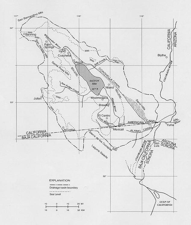
Geographical location of the Salton Sea.
| 051111 |