- Title of Proposed Activity/Project
- Description of Proposed Activity/Project
- Purpose/Goals
- Significance
- Procedures (500 words maximum)
- Plan of Activity/Project
- Collection of water quantity, water quality, agrological, and geotechnical data of the La Joya irrigation project and the Vitor Valley. This includes existing data on consumptive use, water applications, salinity level, leaching factors, cropping history, areal extent, and soil types. New data will be developed as required and permitted within the project timeline. GIS will be used to support this phase of the research.
- Collection and analysis of geotechnical data, including slide size, history, and progression. Remote sensing will be used to support this phase of the research. New data will be developed as needed.
- Perform a water and salinity balance for the La Joya project and the Vitor Valley, including the determination of sources and fates of salinity, and crop type and resistance. Salinity modeling will be used to support this phase of the research.
- Interdisciplinary analysis and synthesis, including institutional and political aspects, to determine the best mitigation strategy to manage the salinity, the excess percolation, and the associated slope slide.
- Timeline of Activity/Project
- Travel or service performed during the period(s) of leave
- List CSU resources, if any, necessary to carry out Activity/Project
- Summary of work already completed on the Activity/Project
- Brief description of anticipated results
- Benefits to the University and its students
- Brief Curriculum Vitae
Hydrologic and environmental impact of intensive irrigation in the Chili-Vitor Valley, Arequipa, Peru.
The purpose of the proposed research project is to study the hydrologic and environmental impact of intensive irrigation being practiced in the Chili-Vitor valley, in Arequipa, Peru. The irrigation of La Joya, located about 70 km from Arequipa, within the confines of the Chili-Vitor basin, has been in operation for the past 65 years. The project has substantially improved the local economy, and the benefits in terms of agricultural production are considerable. However, like other irrigation projects that have been undertaken in similar climatic regions (deserts), there are some pitfalls, among them, notably, the need to manage the wastewaters of the agricultural enterprise. The output waters are more saline that the input waters, resulting in degradation of the water quality downstream.
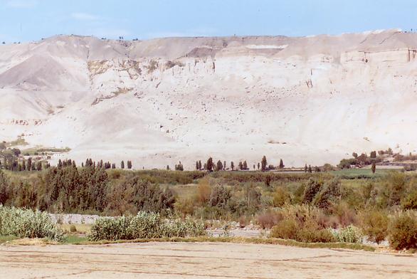
In addition, the La Joya site suffers from a peculiar geomorphologic characteristic: it sits on top of a plateau, above the nearly V-shaped Vitor Valley, with a vertical distance between the plateau and the valley floor of approximately 200 meters. In the past 65 years, the irrigation-applied water of La Joya, in excess of the consumptive use, has percolated through the soil profile and created a geotechnical slide which did not exist prior to development. The slide is slowly progressing (by creep) in a direction perpendicular to the Vitor valley, threatening to eventually dam it up (see Fig. 1). This would have many negative impacts and be unacceptable from a technical, socioeconomic, and political standpoint.
|
Fig. 1 Slide in the Vitor valley, Arequipa, Peru.
Thus, the objective of the project is twofold: (1) to develop a strategy for the proper management of salinity in the context of a major existing irrigation project, including assessment, mitigation, treatment, and disposal, and (2) to develop a strategy to stop or reduce the speed of progression of the existing slide, by managing the irrigation of the La Joya plateau with the aim to reduce or eliminate vertical percolation. A related objective is to strengthen the local institutional capabilities to recognize cause-effect relations in the management of excess salinity, percolation, and irrigation-generated earth-slope slides in the Chili-Vitor Valley.
The proposed project is significant because it tackles a real-world interdisciplinary problem, including water resources, environmental, geotechnical, and institutional aspects. The first issue to be addressed is the propriety of siting an irrigation project along coastal sedimentary regions with predominantly marine geology. The second issue is how to best manage an existing situation, where stakeholders have already developed. The third issue is how to mitigate the effects of excessive salinity in a local/regional environmental context. The fourth issue is how to effectively link the geotechnical slide to the irrigation, i.e., how to establish a cause-effect, to enable the proper assessment of solutions. The uniqueness of the situation, as described, makes it very significant. This is an unusual opportunity to engage in truly interdisciplinary science and engineering, to contribute to the solution of a problem that has an anthropogenic origin, and that is not likely to go away unless something is done to stop it or to mitigate it.
The project plan consists of four phases:
The project will start in September 2007 and extend until December 2007. Phase 1 (Hydrologic data collection) will be carried out during the month of September. Phase 2 (Collection and analysis of geotechnical data) will be carried out during the month of October. Phase 3 (Water and salinity balances) will be carried out during the month of November. Phase 4 (Interdisciplinary synthesis) will be carried out during the month of December. A report and website will be produced to document and adequately publicize the findings of the study. A paper will be submitted for publication in the ASCE Journal of Irrigation and Drainage Engineering.
Travel will be required to collect data and learn first-hand about the salinity, the slope slide, and other local conditions. The period of out-of-state travel will be two months. While in Peru, the principal investigator will be based in Arequipa, with field trips to the sites at the La Joya irrigation project and Vitor Valley as needed.
The on-campus portion of the work will be carried out in the Visualab, located in room 231-B of the Physical Sciences Building. The Visualab is a computer laboratory dedicated to the web-based teaching of water-resources engineering. The lab features the following equipment: one (1) SGI Octane server, four (4) SunBlade 1500 servers, two (2) HP xw8200 desktops, an HP 8200 scanner, and an HP 4100N laser printer. Other CSU facilities to be used include the SDSU Love Library and its online resources.
The Principal Investigator has visited the area of the Chili-Vitor Valley during August 2006. The visit had the purpose to become familiar with the area and its problems prior to the preparation of this proposal. During this visit, the Principal Investigator was accompanied by Prof. Carlos Machicao, of the National University of San Agustin (UNSA), in Arequipa, Peru. Prof. Ponce has been associated with Prof. Machicao for the past eight (8) years, in their capacities as teachers and researchers in the fields of hydraulics, hydrology, and environmental hydrology at universities in California (SDSU) and Peru (UNSA). Prof. Machicao will provide counterpart technical assistance in the execution of the proposed project, and facilitate the use of local laboratory and related facilities (UNSA), including transportation to the field sites.
Prof. Ponce is an expert in the environmental management of irrigation-induced salinity. He has recently published a web-based report entitled: "The Salton Sea: An Assessment." This work was used in a recent feature by Discovery Channel's "Engineering Disasters." In this work, he summarizes the origin, history, status, and strategies for restoration of the Salton Sea, in Imperial County, California. Prof. Ponce has also written two other papers on the restoration of the Salton Sea. His early professional work was in the geotechnical area, having published a paper on the slope stability of channel banks.
A preliminary assessment in the field indicates that some data may already be available locally. Other data, as needed to develop the analysis, models, and strategies, will be collected during the course of the study.
The project will document the relations between irrigation and salinity, and between percolation in La Joya and earth-slope slides in the adjacent Vitor Valley of Arequipa. The results will help local and state decision makers set the proper strategies to manage salinity, excess salinity, excess percolation, and geotechnical problems associated with excess percolation. Specifically, the study will determine: (1) how to manage excess salts in agricultural wastewaters, including water treatment and crop salt tolerance, and (2) the effect of the percolation on the existing slide, and the remedial strategy thereof, including establishing a buffer zone where irrigation, and thus, percolation, would not be permitted. Lack of action in this matter will guarantee that the slide will continue to develop, with serious consequences for the economy and inhabitants of the Vitor valley.
The benefits to the university and its students are many and varied. Prof. Ponce teaches a graduate-level course entitled: "Environmental Hydrology" (CIV E 633). One of the topics of this course is "Salinity Management: Impact of Irrigation on Salinity." This topic is very closely related to the subject matter of this proposal. Prof. Ponce's knowledge of the subject will be enriched by the sabbatical experience. Graduate students would benefit from this enrichment through better real-life content of the lectures. Prof. Ponce will produce a web-based report drawing on his sabbatical experience. This will be benefit the university indirectly, through enrichment of Prof. Ponce's curriculum vitae and web exposure (searchable by Google) on the subject of salinity and irrigation impacts.
Dr. Victor Miguel Ponce has been on the faculty of SDSU for the past twenty-seven (27) years. His areas of expertise are surface-water hydrology, environmental hydrology, computational hydraulics, and hydrologic/environmental impact of development projects. He earned M.S. (1970) and Ph.D. (1976) degrees at Colorado State University, and achieved the rank of full professor at SDSU in 1983.
He teaches Engineering Hydrology (CIV E 445) and Open-channel Hydraulics (CIV E 530) at the undergraduate level, and Computational Hydraulics and Hydrology (CIV E 632), Environmental Hydrology (CIV E 633), and Surface-water Hydrology (CIV E 634) at the graduate level. His extensive experience led to the publication of "Engineering Hydrology: Principles and Practices" (Prentice Hall, 1989). This textbook is being used at many universities in the United States, Canada, and other countries.
In the past year, Dr. Ponce's has completed three research projects: (1) Impact of the proposed Campo landfill on the hydrology of the Tierra del Sol watershed, in San Diego County, (2) Groundwater utilization and sustainability, applied to the San Diego backcountry, and (3) Flood hydrology and hydraulics of Tecate Creek, in Baja California. In 2005, Dr. Ponce was a member of the Peer Review Panel assembled for the evaluation of South Florida's Regional Simulation Model (RSM). In 2004 he completed a study of the sustainable architecture of Arroyo Alamar, in Baja California. In 2003 he completed a study of the hydroecological characterization of Arroyo Alamar. In 2002 he completed a study of three issues of sustainable management in the Ojos Negros valley, in Baja California. In 2001 he completed an interdisciplinary study of groundwater depletion in the Ojos Negros valley. In 1995, he completed a study of the hydrologic and environmental impact of the Parana-Paraguay waterway on the Pantanal of Mato Grosso, Brazil.
Dr. Ponce's international consulting experience include the Inter-American Development Bank (IDB) in Guyana, United Nations Development Program (UNDP) in Argentina and India, European Union (EU) in Bolivia, and Organization of American States (OAS) in Brazil. His professional experience includes work with the Link Canals in Pakistan, the Santa Cruz river in Arizona, the Upper Paraguay river in Brazil, the Pirai river in Bolivia, the San Francisco river in northeastern Brazil, and the Tlaxiaco river in Mexico.
Dr. Ponce's most recent academic collaborations have been with the Universidad Nacional de San Agustin, Arequipa, Peru (1998-2006); Universidad Nacional Agraria La Molina, Lima, Peru (2002-06); Universidad Catolica de Santa Maria, Arequipa, Peru (2005-06); Universidad Mayor de San Simon, Cochabamba, Bolivia (2004); and Universidad Tecnica Particular de Loja, Ecuador (2006).
Dr. Ponce has authored more than 270 publications, including 2 textbooks, 49 refereed journal papers, 69 proceedings papers, and 155 technical reports. He has received numerous honors and awards, including the prestigious National ASCE Karl E. Hilgard Hydraulics Prize in 1979. He has presented more than one-hundred invited lectures in many countries. His website is used around the world as a reference on hydrology and hydraulics.