The Pfafstetter System for Watershed IdentificationThe Pfafstetter Coding system, developed by Otto Pfafstetter in 1989, is a methodology for assigning watershed IDs based on the topology of the land surface (Verdin, 1997). The system is hierarchal, and watersheds are delineated from junctions on a river network. Level 1 watersheds correspond to continental scale watersheds. Higher levels (levels 2, 3, 4, etc.) represent ever-finer tessellations of the land surface into smaller watersheds, which are sub-watersheds of lower level watersheds. Each watershed is assigned a specific Pfafstetter Code based on its location within the overall drainage system and on the total drainage area upstream of the watershed's outlet. According to the Pfafstetter system, watersheds are divided into 3 types - basins, interbasins, and internal basins. A Pfafstetter basin is an area that does not receive drainage from any other drainage area; a basin contains the headwater of the river reach for which the watershed is defined. Conversely, a Pfafstetter interbasin is a watershed that receives flow from upstream watersheds. Finally, an internal basin is a drainage area that does not contribute flow to another watershed or to a waterbody (such as an ocean or lake). The assignment of IDs is irrespective of level, and is carried out with the following basic steps: 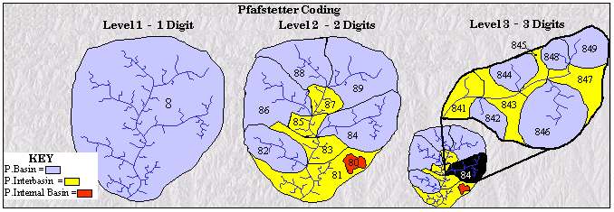
Figure 1 - Pfafstetter Levels 1, 2, and 3 - Individual watersheds are numbered in an upstream direction
These assigned codes are then appended on to the end of the Pfafstetter code of the next lowest level. For example, in assigning level 3 codes, each level 2 watershed is divided into at most ten sub-watersheds, and these sub-watersheds all have the level 2 code XY. The level 3 codes of these sub-watersheds become XY0, XY1, XY2, etc. |
| 131116 |