|
RED CLOVER CREEK: PAST AND PRESENT
In July 2010, I attended the 25th anniversary celebration of the Feather River Coordinated Resource Management Group (FRCRMG),
in Quincy, Plumas County, California. The three-day event included a tour of Red Clover Creek, which for many years
has been at the center of this agency's efforts to manage river ecosystems in the California Sierras.
The story of Red Clover Creek teaches us some important lessons.
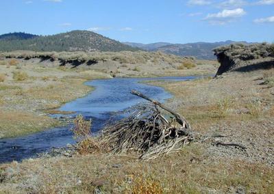
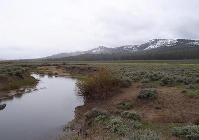
Prior to the middle 1950s, Red Clover Creek was a relatively shallow stream with permanent baseflow supporting
an excellent fishery. However, in the late 1940s and early 1950s, federal programs were introduced to eliminate willows
[phreatophytes] using aerial herbicide spraying. At about the same time, over three hundred beaver were removed from the system.
These actions, together with the longstanding effects of heavy grazing and a system of abandoned logging railroad grades in the valley,
brought Red Clover Creek to the brink of disaster.
The 1955 flood was the catalyst for the massive gully formation through the valley, which continued through most of the 1980s.
Once the gully formed, the regional water table dropped, baseflow was all but lost, and erosion and sediment transport followed. Of all the
reasons for the formation of the FRCRMG in 1985, none was more important than the loss of Red Clover Creek.
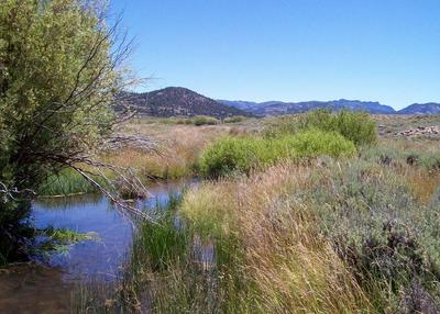
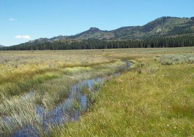
Happily, after many years of enlightened management, Red Clover Creek is now returning to its former
state: stable, self-sustaining, and with permanent baseflow.1 The restoration work began in 1985 with the installation of four loose-rock checkdams.
Ten years later, the FRCRMG developed a new technology to use in place of checkdams.
Called "pond and plug," it seeks to eliminate the gully through onsite excavation and fill, forcing the water
level in the valley to rise to meet the historic remnant channels and floodplain. In 2006 this technique was used on
additional portions of Red Clover Creek below the original check-dam project. After treatment of 4.5 miles of stream channel, the project
is now in its first season of recovery, as shown in the [before and after] photos below.2
1 Ponce, V. M., and D. S. Lindquist. 1990. Management of baseflow augmentation: A review. Water Resources Bulletin, Vol. 26, No. 2, April.
2 Photos courtesy of Jim Wilcox, Plumas County, California.
|