|
|
CIVE 445 - ENGINEERING HYDROLOGY
USDA: INFLUENCES OF VEGETATION AND WATERSHED TREATMENTS ON RUNOFF, SILTING, AND STREAMFLOW
|
|
1. SOIL, VEGETATION, AND WATER FLOW
|
- Relationships between land use and runoff have followed logging, cultivating, burning, and grazing.
- Even the more precise engineering calculations have their limitations in dealing with runoff and streamflow.
The water cycle
- The total quantity of water does not vary over long periods of time.
- The atmosphere absorbs water in evaporation.
- The water released through vegetation is called transpiration.
- On a global average, evapotranspiration amounts to about 70 percent of precipitation; the rest is runoff.
- Entrance of water to the soil is called infiltration.
- The water stored underground is called groundwater.
- Groundwater eventually discharges to seeps and springs, except in closed basins (endorheic drainage).
- Excess water flows on the surface as runoff.
- The surface soil separates runoff from infiltration.
- Humans manipulate infiltration and evapotranspiration; the first one through paving; the second one through changes in land use.
- Human manipulation leads to changes in the hydrologic cycle, mostly conversion of baseflow to direct runoff.
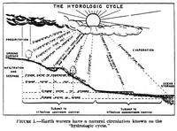
Fig. 1
|
|
Land storage of water
- The earth's surface is a relatively porous body capable of absorbing and holding a tremendous quantity of water.
- With rare exceptions, groundwater is supplied downward from the surface.
- Groundwater is dependent on the quantity of precipitation and the characteristics of infiltration.
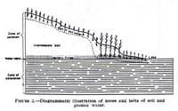
Fig. 2
|
|
Groundwater storage
- The soil profile hold water temporarily, until it is partially recovered through springs and wells.
- The depth to groundwater varies with location.
- Average values have been reported in the U.S. at 37 ft (11 m).
- In some arid regions, groundwater depths are at 2000 ft (this in an extreme case).
- The steady flow of streams and the maintenance of natural lake levels is dependent on groundwater.
Character of flood-producing rains
- Intensity, duration, and area of the storm determines the runoff.
- There are two types of storms:
- local,
- general.
- Local storms are intense showers of short duration covering a relatively small area (less than 10 sq mi).
- General storms produce a longer-lasting storm of more homogeneous pattern covering a large area.
- Some general storms cover 400,000 square miles and may last several days.
- The storm of October 30, 1983, over southeastern Arizona covered about 50,000 square miles.
- Duration (and depth) is a factor of great importance in storms producing widespread floods.
- In small watersheds, rainfall intensity is the most critical factor.
- Rainfall patterns change in time and space;
some may not yield excessive runoff, while others may produce major flood catastrophes.
|
2. FACTORS AFFECTING INFILTRATION
|
Soil porosity
- Soil porosity allows storm water to enter the soil.
- The quantity of soil air that can be displaced by water varies with the physical and chemical characteristics of the soil.
- In certain soil types, water may occupy 90 percent of the pore space.
Organic matter content of soil
- There is a direct correlation between the quantity of humus (organic matter) in soil and its water-holding capacity.
- Forest soils can take more water than desert soils.
- In one experiment, the water holding capacity went from 44 percent to 81 percent as organic matter increased from
2.4 percent to 10.5 percent.
- Organic matter is more influential than either soil moisture or soil texture in determining the rate and volume of infiltration.
Fig. A: Detail of peat bog.
|
Plant roots form channels
- Channels left by decayed roots (macroporosity) perform an important function in soil infiltration.
- While the roots are alive, their growing tips force a way into minute cracks in the soil granules, expand, and enlarge the opening.
- When the roots die, they soon decay, leaving channels through which water penetrates into the soil.
Plant and animal life
- The soil is home to much of the animal life.
- In the Appalachian region, up to 10,000 microarthropods may inhabit each square foot of forest litter.
- Darwin estimated that 50,000 worms inhabit an acre of ground.
- These creatures burrow in the upper 18 inches, but may work down to 8 ft.
- All such plant and animal life influence the moisture intake and moisture-holding capacity of the soil.
- They are unquestionably important in determining infiltration rates.
- Any modification of plant cover (by cultivation, burning, or overgrazing) adversely affects soil fauna and reduces the rate of infiltration.
Slope and soil influences
- Slope is less important than degree of cover, intensity of precipitation, or soil characteristics.
- When cover and other impediments to runoff are decreased, slope is more likely to result in proportionately greater storm flow.
Infiltration after saturation
- Water that infiltrates does not form part of direct runoff or storm flow.
- Extremely dry soils are less capable of absorbing water than moist soils.
- Where soils are unable to absorb rainfall in appreciable quantities, the phenomenon is generally due
to the disturbance of the normal infltration process in the surface layer.
- During intense rains, large
amounts of surface runoff frequently originate from sloping cultivated fields in which dry soil is found
2 to 3 inches below the surface.
- However, forests soils are invariable saturated.
|
3. INFLUENCES OF VEGETATION ON WATER BEHAVIOR
|
Influences on infiltration
- If water infiltrates into the ground, it becomes available for the growth of plants useful to humans, and replenishes groundwater supplies.
- In time, a significant (almost all, close to 99%)
portion may reappear in streams, augmenting the low-water flow to the benefit of industries and municipalities
that use the stream flow.
- Vegetation is human's strongest ally in bringing about maximum use of the water resource (storage as opposed to surface runoff).
- Lowdermilk's quote:
"When a drop of rain strikes the ground covered with vegetation,
it breaks into a spray of clear water
which finds its way into the numberless interstices and channels of the soil; but
when it strikes bare soil, formerly developed under a mantle of vegetation, the force of the drop causes it to
take up particles into suspension: it becomes a drop of muddy water. As this sinks into the soil,
the fine particles filter out at the surface to form a thick film which chokes up the
surface pores of the soil. Then only a part of the drop filters into the soil, another part is left unabsorbed and flows over the surface;
the accumulation of infinite unabsorbed drops on sloping land gives rise to superficial storm flows."

Fig. 5
|
|
Interception of precipitation
- Studies in North Carolina have shown that for significant storms (0.2 in or more), the amount of precipitation intercepted
by the canopies may vary from 1 to 33 percent of the total.
- The controlling factors are composition, age, condition of the vegetative stand, and season.
- On an annual basis, the amount of rain intercepted by vegetation may be large.
- However, on an event basis, this amount depends on the frequency (or return period).
- A relatively large fraction of light storms is prevented from reaching the soil,
whereas in heavy rains the proportion is much smaller.
- Interception is important for yield hydrology, but not for flood hydrology.
Reduction of evaporation from the soil
- Vegetation, particularly forest cover, greatly reduces the rate of evaporation from the soil.
- For example, evaporation measured in the spring in New Jersey, in an open short-bodied stand of pine and oak measured only 65%
of that in the open.
- In Europe, evaporation in the open amounted to 50% of precipitation, while in a forest, this value was reduced to 15% to 20%.
- This reduction is due to the different energy balance in a vegetative stand and in the open, affected by the local albedo.
Water consumed by vegetation
- The water requirements vary with different plants.
- The total amount of water depends primarily upon prevailing climatic conditions.
- Actual evapotranspiration is very difficult to measure.
- Consumptive use of water by vegetation is also related to soil fertility.
- Plants growing on fertile soil can make more efficient use of water than plants growing on infertile soils.
- In other words, on a cultivated, eroded, infertile soil, plants require a larger number of units of water to produce a unit of dry matter.
- These soils have less water available for plant use.
- Therefore, cultivation of marginal lands is inefficient from the water standpoint.
Absorption by plant litter
- In the U.S. Northeast, the water-holding capacity of plant litter ranges from 300 to 900 percent of its dry weight.
- Litter exerts much influence on the water conditions for a region.
- Forests stands with well developed litter can hold and retain a lot of water.
Retardation of runoff
Retardation of snowmelt
- In regions with heavy snow, forest cover retards melting in the spring.
- Melting of snow under forest cover takes place at a slower rate than on open land.
- The retardation is due to shading of the ground, and to reduction in wind movement.
Protection from freezing
- Frozen soils do not occur under deep snow cover or good plant cover.
- Depth and distribution of snow are influenced by the character of the plant cover.
- Bouyoucus found that soil did not freeze under a cover of snow and vegetation, whereas subfreezing temperatures were almost continuous in bare
soil.
|
4. CONSEQUENCES OF CHANGE IN VEGETAL COVER
|
Extent of modification of cover
- As the country was settled, hundreds of millions of acres of forests and grassland necessarily gave way to agriculture.
- Millions of acres that should have remained permanently in timber or grass were put to the plow.
- Other millions of acres were farmed exploitively rather than conservatively.
- On the whole, there has been a great reduction in total plant cover.
- Approximately 100 million acres still largely in cultivation have lost most of the topsoil.
- Deposition of eroded soil in stream channels and storage reservoirs has increased flood damage, increased dredging expenditures,
and destroyed the utility of a large number of reservoirs.
Clearing and cultivation
- Land must be cleared and cultivated.
- Probably 3/4 of the Earth's people live on plains and low uplands where main drainages are visited by floods, the source of which are often
in another physiographic environment.
- Measurements of soil and water loss in Ithaca, N.Y., are shown in Figure 7.

Fig. 7
|
|
- It is significant to note that the ground beneath the cover of forest litter was not frozen, whereas the soil in the potato field was.
- There is a tremendous capacity of certain vegetated soils to absorb large quantities of moisture.

Fig. 8
|
|
- Bradfield's quote:
"As a result of these changes in structure, root development is hampered,
the storage capacity of the soil for water is reduced, flood
hazard is increased, and the damage from frequent periodic floods is magnified."
Fire damage
- Fire is the most widespread and destructive disturbing agency of natural cover.
- In some forest types, the litter commonly is entirely consumed by periodic ground fires that cause no great damage to the standing trees.
- Fire can also destroy the humus in the topsoil.
- In Southern California, chaparral fires can lead to debris flows.
- Removal of natural vegetation contributes to floods and excessive erosion.
- In the Clearwater river, Idaho, the fires increased the spring flood at the expense of the summer flow; that is, they resulted
in the conversion of subsurface to surface runoff.
- In Oklahoma, runoff from an unburned plot was clear water and totalled 250 gallons per acre; that from the burned plot, with the same soil and slope,
was muddy and amounted to 27,600 gallons per acre, more than 100 times more.
Logging
- On a clear cut area there is no longer appreciable interception of precipitation by tree crowns,
and little high shade to retard snow or prevent evaporation.
- In Colorado, flood crests were advanced about 3 days and the maximum height of the flood crest averaged 64 percent greater in the cut-over area
than in the undisturbed watershed.
- The silt load of the stream after logging increased 7.5 times.
Overgrazing
- Grazing will reduce the quality of plant cover and the concomitant trampling will compact the soil.

Fig. 13
|
|
- Wasatch, Utah experience: waters heavily laden with silt had collected on small areas of private land at the head of the drainages,
where the vegetative cover had been destroyed or become seriously depleted by overgrazing, fire, and to some extent by logging.
- A many branched, fibrous root system is an important factor in retarding soil erosion.
- Bunchgrass yielded only 0.4% runoff and 6 lb. per acre of eroded soil.
- The downy chess and needlegrass-lupine, which have succeeded the bunchgrasses at lower and higher elevations, respectively,
are less effective watershed covers; runoff was 25.5% and 47.6%, and erosion was 2,017 and 4,785 lb. per acre, respectively.
- An annual weed provided the least protection, with runoff amounting to 60.8% and erosion to 15,280 lb. per acre.
- This shows the effect of overgrazing.
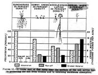
Fig. 15
|
|
Silting of reservoirs
- There are more than 60,000 dams and reservoirs in the U.S.
- Many reservoirs will fill up with sediment prematurely, due to upland erosion.
- The cost of silt removal from reservoirs is generally 5 to 20 times greater than the cost of the original storage.
Shoaling of channels
Damage to flood-plain soils
- In the Ohio valley, the flood of January 1937 caused erosion in 70,000 acres of upland, and deposition of silts in 320,000 acres and sand
in 22,000 acres.
- There was little permanent damage to valley lands affected by deposition of silt and loam.
- In contrast, deposition of 3 in of sand had caused definite impairment of productivity.
- The area covered by more than 3 in of sand was 5,700 acres.
|
5. RUNOFF AND EROSION CONTROL BY CROPPING PRACTICES AND MECHANICAL MEASURES
|
Crop rotations, green manure, and winter cover crops
- Winter cover crops and green manure crops contribute to soil and water conservation.
- They protect the land during their growing period and add to the organic content of the soil when plowed under.

Fig. 20
|
|
Strip cropping
- Strips of close-growing crops placed on the contour are alternated with strips of clean-tilled crops.
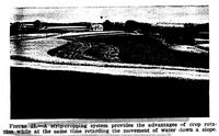
Fig. 21
|
|
Terracing
- Terracing has an important place in the upstream control of storm runoff.
- In more humid climates, it is necessary to lay terraces on a slight grade in order to provide drainage, and, therefore,
terraces are not as effective for conserving water.
- In dry climates, terraces are laid on the contour and all the water is held in the field.
- Farming up-and-down the slope forms channels and greatly contributes to erosion and land degradation.
- In Oklahoma, terracing and contour tillage increased average soil moisture 25%.
- In the Wasatch Mountains, Utah, terrace-trench system of erosion control was tested in 1936.
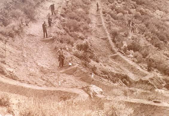
Fig. U: Construction of terrace-trench system
in the Wasatch Mountains, Utah, 1936.
|
|
- On two occasions, very serious mudflows occurred on four unterraced tributaries, whereas the terraced watersheds provided adequate
protection against flash floods.
- In one particular storm in 1936, observations revealed that all of the runoff which contributed to the flash flood came from only 5% (7.5 acres),
principally from cleared areas surrounding buildings, and from roads.
- No surface runoff was contributed from the remaining 95%, which was covered by dense stands or treated with the terrace-trench system.

Fig. X: Age-old agricultural terraces in the Himalayas, India.
|
|
Structures
- All check dams and other forms of small dams contribute to water retention and flood hydrograph diffusion.
- In humid areas, check dams are built to stabilize gullies and prevent further growth.
- In dry areas, they are built to conserve water for livestock use, which otherwise would be wasted.

Fig. Y: Check dams made out of vegetation.
|
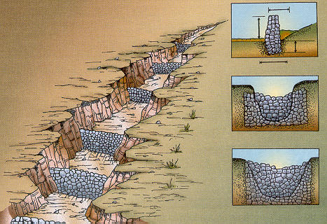
Fig. Z: Check dams made out of gravel and stones.
|

Fig. YY: Beaver dam in a tributary of Trout Creek, Colorado.
|
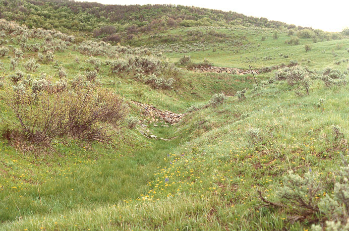
Fig. ZZ: Check dams built by the USDA Forest Service
in Alkali Creek, Colorado, 1963.
|
|
|
http://ponce.sdsu.edu/cive445_ponce_usdainfluences_lecture.html
|
210703
|
|