|
|
DRAINAGE BASIN OF THE ALTIPLANO, SOUTH AMERICA
Joseph H. Chua and Victor M. Ponce
15 October 2010
|
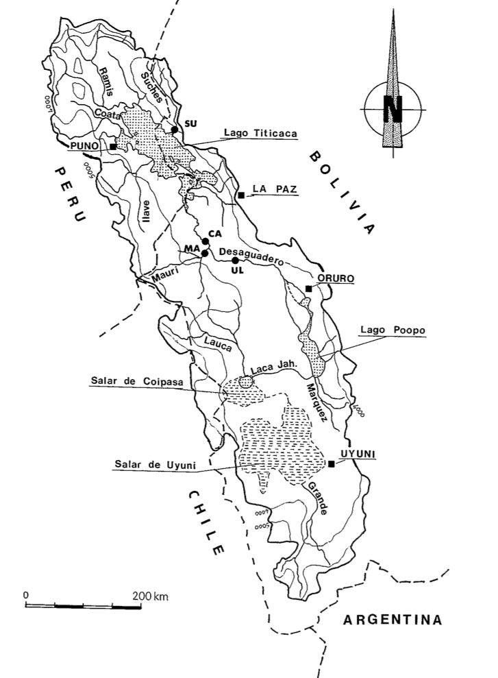
The drainage basin of the altiplano located in the countries of Bolivia, Chile, and Peru is a large narrow depression surrounded
by the Eastern and Western Cordilleras of the Andes Mountain Range. The basin is an endorheic system that covers an area of
approximately 191,000 km2. The main drainage of the basin is composed of Lago Titicaca, Rio Desaguadero, Lago Uru Uru, Lago Poopo,
Rio Laca Jahuira, Salar de Coipasa, and Salar de Uyuni. In this article, the altiplano basin is divided into three zones: Northern, Central, and Southern.
Titicaca is located in the northern zone; Desaguadero, Uru Uru, and Poopo in the central zone; and Jahuira, Coipasa, and Uyuni in the southern zone.
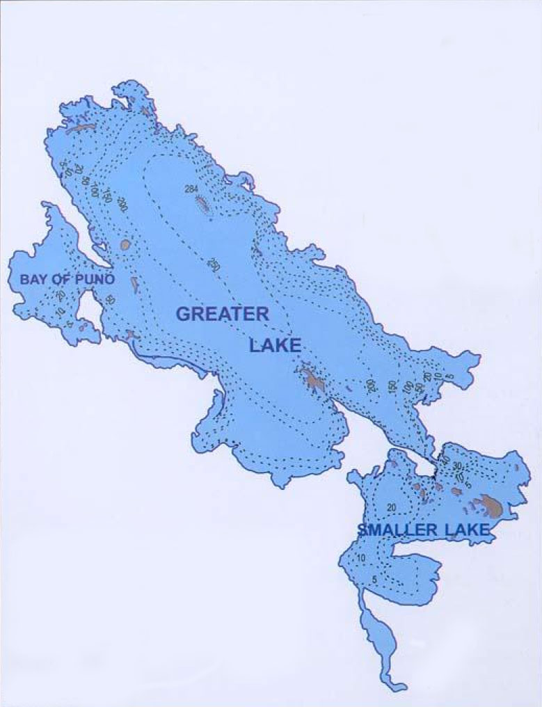
Lago Titicaca is the largest navigable lake in South America and is divided into three regions: 1) Bay of Puno, 2) Greater Lake, and 3)
Smaller Lake. Precipitation is the only incoming source of water and evaporation is the major outgoing source that helps maintain
a constant level in the hydrologic cycle. The incoming sources are precipitation (55%) and rivers (45%). The outgoing sources are evaporation
to the atmosphere (95%), percolation to aquifers (3%), and outflow to Rio Desaguadero (2%).
Rio Desaguadero receives outflow from Titicaca and from several other tributaries along its course and eventually flows into Lago Poopo.
The discharge of Rio Desaguadero is related to the average monthly gauge heights of Lago Titicaca indicating that the river is mostly supplied
by the lake.
Lago Uru Uru is a small, shallow lake which was formed in 1962 by the flow of Rio Desaguadero and by the accumulation of sediment through soil
erosion. During the wet season, the lake spills over into Lago Poopo.
Lago Poopo is a large, extremely shallow salt lake. Water input to the lake comprises of: 1) seasonal precipitation directly onto the lake,
2) variable inflow from twenty two seasonal rivers, and 3) direct inflow from Rio Desaguadero. In general, studies have shown that Poopo is
a closed basin; however, the lake can spill over to Rio Laca Jahuira.
Rio Laca Jahuira existence relies on the overflow from Lago Poopo. This amount of flow is quite small but high in dissolved solids concentration.
At times, it can reverse its flow during the rainy season depending on the water level of Poopo.
Salar de Coipasa contains a very small salt lake which is surrounded by salt crusts. Also, contained within Salar de Coipasa is a volcanic
cone, Villa Pucarani. Annual rainfall in the basin varies from 500 mm in the north to 200 mm in the south. The region receives a majority
of its precipitation from December through March. Evaporation rates of 1200-2200 mm greatly exceed precipitation rates. This salar is considered
to be an evaporative sink for the Altiplano basin due to intense evaporation and as a result has accumulated vast quantities of salts.
Salar de Uyuni is a large salt flat made up of salt crusts with an almost perfectly smooth, flat, level, homogeneous, and highly reflective surface
which is maintained by annual flooding during the rainy season. It has the smoothest and flatest salt surface on Earth. Annual rainfall in the
basin varies from 250 mm in the north to less than 100 mm in the southeast. The region receives a majority of its precipitation from December through March.
Evaporation rates of 1200-2200 mm greatly exceed precipitation
rates.
|
1. INTRODUCTION
|
|
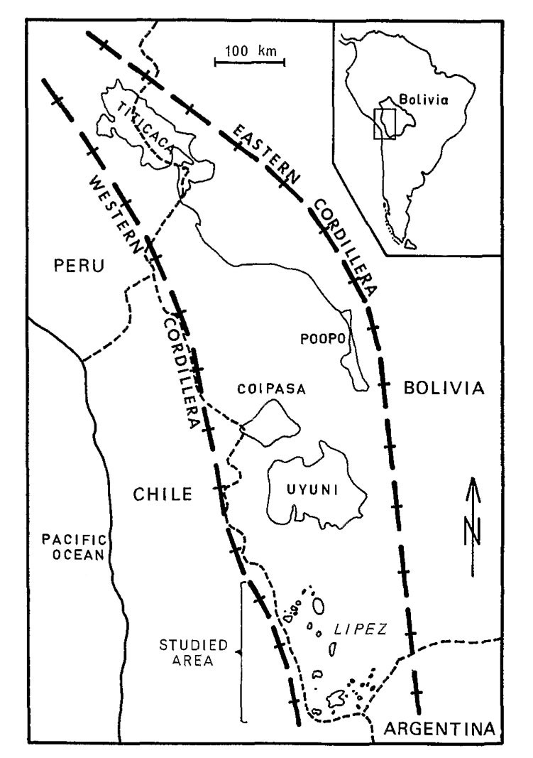
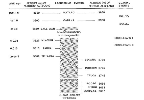
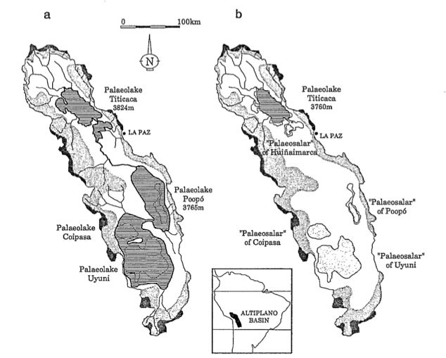
The Altiplano (high plateau) of South America contains an endorheic drainage basin that covers an area of approximately 191,000 km2, with 69% in Bolivia, 27% in Peru, and 4% in Chile (Fig. 1). The basin is a large, narrow depression, 200 km wide and 1000 km long, comprised of a series of plains, highlands, and isolated hills which are surrounded by the Eastern and Western Cordilleras of the Andes Mountain Range (Fig. 2). The Eastern and Western Cordilleras were formed between the Eocene and Miocene periods. The Altiplano itself began formation during the Miocene times and eventually ended in the post-Pliocene times, resulting in the last uplift of the plateau. Paleolakes named Mataro and Cabana filled the entire basin approximately 1 to 1.5 million years ago. As years passed, the lake levels receded to what is called Ballivian, Minchin, and Tauca in the Northern Altiplano; and Escara, Minchin, and Tauca in the Central Altiplano, approximately 13,000 to 600,000 years ago (Fig. 3). Today these lakes are known as Lago Titicaca, Lago Poopó, Salar de Coipasa, and Salar de Uyuni (Aquize; Guyot, 1990; Wirrmann, 1995; Moon, 1955).
|
Fig. 1 Altiplano drainage basin in Bolivia, Chile, and Peru (Guyot, 1990).
|
Fig. 2 Altiplano in relation to cordilleras (Risacher, 1990).
|
Fig. 3 Paleolakes (Wirrmann, 1995).
Maximum elevation of 6,542 m above sea level (asl) exists at Mount Sajama, average elevation of over 5,000 m in the surrounding mountains, and minimum elevation of 3,653 m at Salar de Uyuni. The Altiplano climate is characterized as semiarid with pastures in the north (Titicaca) to arid with sparse vegetation in the south (Salares). Temperatures will vary depending on the region, but generally, during the summer, it is moderate at daytime and cold at night with 6-10° C average annual temperatures; however, it can get very cold in the winter. Precipitation decreases from upstream to downstream (North to South). Average rainfall is about 710 mm for the Titicaca sub basin, 390 mm for Poopó, 240 mm for Coipasa, and 190 mm for Uyuni. The wet season is from December to March and the dry season is from May to July. Evaporation is very high reaching annual means of 1450 mm at Lago Titicaca and 1900 mm along the south (Guyot, 1990).
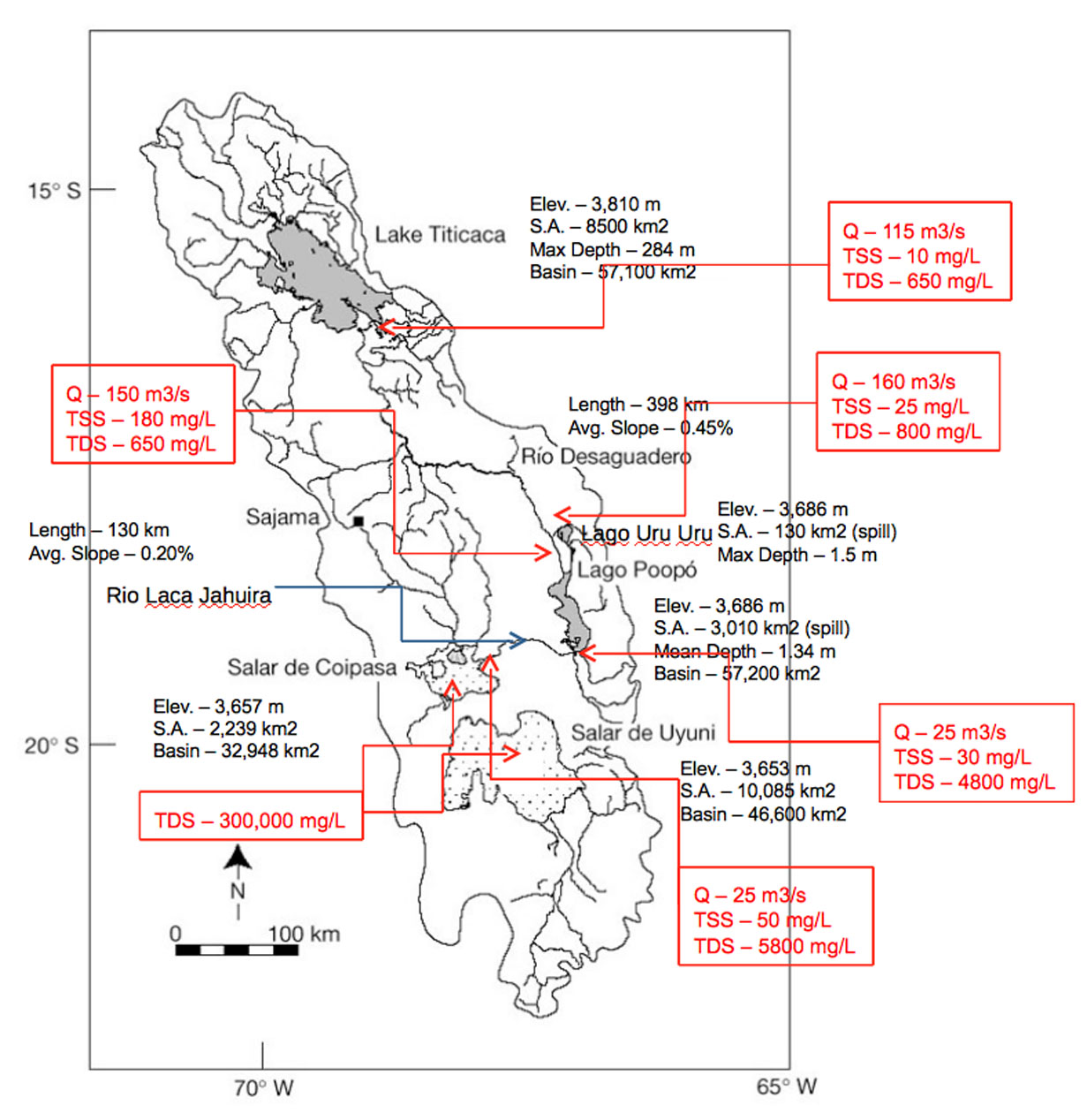
Main drainage for the basin consists of Lago Titicaca, Río Desaguadero, Lago Uru Uru, Lago Poopó, Río Laca Jahuira, Salar de Coipasa, and Salar de Uyuni. Various subbasins can be found within the Altiplano: Titicaca (57,100 km2), Poopó (57,200 km2 which includes Desaguadero and Uru Uru areas), Coipasa (30,200 km2 which includes Laca Jahuira area), and Uyuni (46,600 km2). The river network consists of two types: Andean rivers (originating from the Andes, featuring high gradients) such as Suches, Ramis, Coata, Ilave, Mauri, Lauca, Grande, and Marquez; and system rivers (connecting the lakes and salares) such as Desaguadero and Laca Jahuira (Fig. 1). Seasonal rivers do exist, but are not permanent; therefore, they will not be discussed here (Aquize; Guyot, 1990; Banks, 2004).
In this report, the Altiplano is divided into three zones: Northern, Central, and Southern. Titicaca is located in the Northern Altiplano; Desaguadero, Uru Uru, and Poopó in the Central Altiplano; and Laca Jahuira, Coipasa, and Uyuni in the Southern Altiplano.
2. NORTHERN ALTIPLANO
|
|
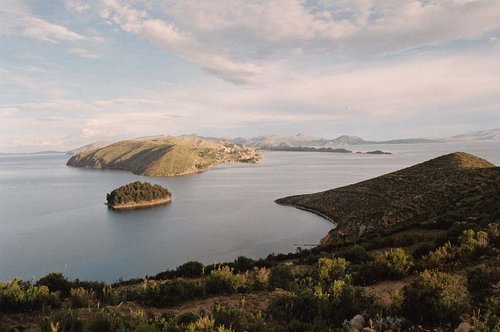
Lago Titicaca
Lago Titicaca is the second largest freshwater lake in South America and the highest navigable lake in the world (Fig. 4). The lake formed tectonically millions of years ago during the Quaternary period where strata subsided and created a trough covered with glacial water and precipitation. The initial water level of the lake was about 150 m higher than the present level. The lake is divided into three zones: 1) Bay of Puno with 560 km2, 2) Greater Lake (Chucuito with 6,540 km2), and 3) Smaller Lake (Huiñaymarca with 1,400 km)2 (Fig. 5). The Greater and Smaller Lake zones are connected by the Tiquina Strait which is 850 m wide and 21 m deep.
|
Fig. 4 Lago Titicaca from Isla del Sol.
Precipitation is the only incoming source of water and evaporation is the major outgoing source that helps maintain a constant level in the hydrologic cycle. The incoming sources are precipitation (55%) and rivers (45%). The outgoing sources are evaporation to the atmosphere (95%), percolation to aquifers (3%), and outflow to Río Desaguadero (2%). The lake and its basin are located in a region containing both permanent and seasonal rivers originating from the Andes Mountains. The permanent rivers such as Suches, Ramis, Coata, Ilave, Huancane, and others provide a total annual flow of 190.47 m3/s. Precipitation accounts for 238.21 m3/s, and evaporation is estimated at 403.20 m3/s. Taking into account other losses at about 5 m3/s, there appears to be a mean annual surplus of 20.74 m3/s that overflows to Río Desaguadero, the lake's only outlet located at the southern end of Smaller Lake. However, there are periods (days, months, or years) when it behaves like an inlet. This occurs when the lake's water level is low and when there is strong precipitation in the Callacame and Mauri River basins which flow into Río Desaguadero near its mouth (Aquize; Revollo, 2001).
|
Fig. 5 Titicaca Zones (Aquize).
Characteristics of Lago Titicaca
| Length
| 179 km
| Volume
| 932 km3
| Average Width
| 50 km
| Maximum Depth
| 284 m
| Perimeter
| 915 km
| Altitude
| 3810 m asl
| Surface Area
| 8500 km2
| Basin Area
| 57,100 km2
| Average Temperature
| 13° C (11 to 15° C) - water | 7°C (-1° C to 15° C) - air Regional Climate
| Cold and Semiarid
| Salinity
| ~0.5 - 1.0 g salt/L H2O
| Classification
| Freshwater
| | ||||
3. CENTRAL ALTIPLANO
|
|
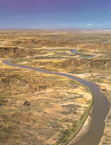
Río Desaguadero
Río Desaguadero has a length of 398 km and average slope of 0.45% and lies within a basin area of 29,843 km2(Fig. 6). The Desaguadero receives water from several tributaries along its course and bifurcates, eventually flowing into Lago Poopó. When Río Desaguadero's discharge is high, the river divides into two branches. One branch leads to Lago Uru Uru, and the other leads directly to Lago Poopó. During the flood of 1985, the Desaguadero changed its course. High flows due to the flood created the present main branch to Lago Poopó. Before this event, the single river branch meandered through the present Lago Uru Uru; thus, a recent geomorphological change had occurred. The discharge of Río Desaguadero is related to the average monthly gauge heights of Lago Titicaca, which indicates that the river is mostly supplied by the outflow of the lake (Aquize; Zola, 2007; Revollo, 2001; Guyot, 1990).
|
Fig. 6 Rio Desaguadero.
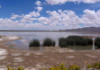
Lago Uru Uru
Lago Uru Uru is a small, shallow lake with a maximum depth of 1.5 m and is situated at an elevation of 3,686 m asl (Fig. 7). It has a surface area of 214 km2 and lies in a basin of 24,829 km2. Lago Uru Uru was formed around 1962 by the flow of the Río Desaguadero and by the accumulation of solid materials through soil erosion. When the surface area of Lago Uru Uru is about 130 km2, the lake spills over into Lago Poopó; however, during the dry season, this flow does not occur. During periods of flood, the lake can attain a maximum surface area of 350 km2 (Zola, 2007).
|
Fig. 7 Lago Uru Uru.
Lago Poopó
Lago Poopó is a large, extremely shallow salt lake with a mean depth of 1.34 m situated on the Central Altiplano at an elevation of 3,686 m asl (Fig. 8). Large sections of the lake have depths less than 0.25 m. It has a surface area of 3,191 km2 and lies within a basin of 24,829 km2. The lake is considered wet when it reaches a surface area of 2000 to 2500 km2 and dry when it reduces to 1000 to 1500 km2. The regional climate is cold, semiarid, and arid (southern part of the lake). Because of its shallowness and flat shores, evaporation can significantly reduce the lake's surface area. In fact, the lake had dried out completely between 1994 and 1997. Water input to the lake is comprised of 1) seasonal precipitation directly onto the lake, 2) variable inflow from twenty-two seasonal rivers, and 3) direct inflow from Río Desaguadero. In general, two studies have shown that the Poopó basin is closed; however, the lake could spill over to Río Laca Jahuira which connects to Salar de Coipasa (Carmouze, 1978; Mariaca, 1985). The lake's surface area at spill-over depth is 3,010 km2. During the flood of 1985, the lake had reached a surface area of 3,500 km2. Due to the lake's shallowness, surface area increases by 100 km2 for every 0.1 m increase in water level (Zola, 2007; Guyot, 1990).

|
Fig. 8 Lago Poopó.
4. SOUTHERN ALTIPLANO
|
|
Río Laca Jahuira
Río Laca Jahuira in a westerly direction connects Lago Poopó to Salar de Coipasa. It has an average length of 130 km and average slope of 0.2%. Its existence relies on the overflow from Lago Poopó. The amount of flow is quite small but high in dissolved solids concentration. At times, it can reverse its flow during the rainy season depending on the water level of Poopó. This connection is a reminder that a single paleolake of a large area existed during parts of the Quaternary period (Revollo; Guyot, 1990).
Salar de Coipasa
The Salar de Coipasa contains a very small, shallow salt lake surrounded by salt crusts (Fig. 9) (see Section 6). The lake has a depth of 3.5 m which is fed by Río Lauca, a regional Andean river. Also, contained within Salar de Coipasa is a volcanic cone, Villa Pucarani, with an elevation of 4,910 m at the apex. Salar de Coipasa is situated at 3,657 m asl, has a surface area of 2,239 km2, and lies within a basin of 30,200 km2. Temperatures range from -25° C in winter and 30° C in summer with annual averages varying between 5-9° C. Annual rainfall in the basin varies from 500 mm in the north to 200 mm in the south. The region receives a majority of its precipitation in a short rainy season (December to March) and receives very little rainfall the rest of the year. Evaporation rates of 1200 to 2200 mm greatly exceed precipitation rates. This salar is considered to be an evaporative sink for the Altiplano basin due to intense evaporation and as a result has accumulated vast quantities of salts. The Salar de Coipasa may receive spill-over flow from Lago Poopó via Río Laca Jahuira; however, this flow amount is quite small and high in dissolved solids concentration. There are several regional Andean rivers originating from the Western Cordillera that flow into Coipasa (e.g., Río Lauca) which also play an important role in the salinity concentration of Coipasa (Revollo; Banks, 2004).
|
Fig. 9 Salar de Coipasa.
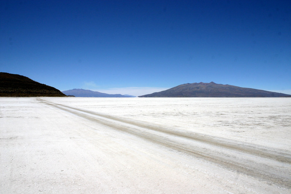
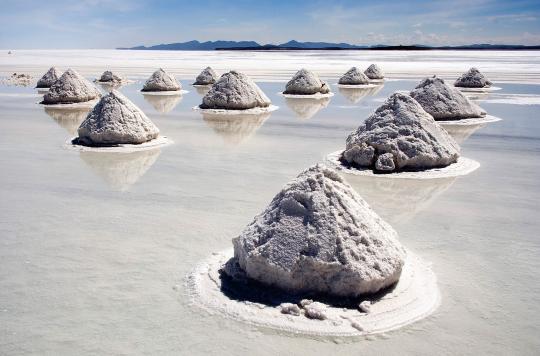
Salar de Uyuni
Salar de Uyuni is a large salt flat made up of salt crusts with an almost perfectly smooth, flat, level, homogeneous, and highly reflective surface which is maintained by annual flooding during the rainy season to a mean depth of 30 to 50 cm (Fig. 10) (see Section 6). It is probably the smoothest and flattest salt surface of its size on Earth. Uyuni is approximately situated at 3653 m asl, has a surface area of 10,085 km2, and lies within a basin of 46,600 km2. Temperatures range from -25° C in winter and 30° C in summer with annual averages varying between 1-8° C. Annual rainfall in the basin varies from 250 mm north to less than 100 mm in the southeast.
|
Fig. 10 Salar de Uyuni.
The region receives a majority of its precipitation in a short rainy season (December to March) and receives very little rainfall the rest of the year. Evaporation rates of 1200-2200 mm greatly exceed precipitation rates. This salar is considered to be an evaporative sink for the Altiplano basin due to intense evaporation and as a result has accumulated vast quantities of salts. During periods of high flow or flood, the Salar de Uyuni receives overflow from Coipasa. There are several regional Andean rivers originating from the Western Cordillera that feed into Uyuni (e.g., Río Grande) which play an important role in the salinity concentration of Uyuni (Bills, 2007; Banks, 2004).
5. SEDIMENT AND SALINITY
|
|
Total Suspended Solids (TSS)
Lago Titicaca does not yield TSS/sediment to Río Desaguadero. Río Suches, north of Lago Titicaca, originates from the Eastern Cordillera, crosses a "primary detrital series" region, and feeds Titicaca with a low sediment yield. Incoming sediment load decreases greatly in Lago Titicaca because all suspended material is being deposited in the lake due to its deep water column. Titicaca is a deep lake; thus, sediment has time and space to settle. Most of the sediment seems to come from the rivers of the Western Cordillera, such as Río Mauri which traverses a "Tertiary volcano-sedimentary" region and feeds directly into Río Desaguadero. Río Desaguadero's upstream basin contributes low sediment levels of sedimentary rocks from the highlands due to gentle slopes. Downstream of Lago Titicaca, the TSS concentration and water discharge increase significantly along Río Desaguadero (due to tributaries with their sediments feeding into Desaguadero) and decrease drastically as soon as the river enters the flood zone of the Uru-Uru/Poopó system where strong evaporation begins and increases southward. This drop in TSS concentration is due to the increasing effects of evaporation. As water evaporates, the lesser amount of solids can be suspended; thus, sediment is deposited in Lago Poopó and is negligible at its exit. In general, water discharge, Q, is directly proportional to Total Suspended Solids, TSS (Figs. 11 and 12) (Guyot, 1990).
Total Dissolved Solids (TDS)
Approximately 70% of TDS/salts supplied to Río Desaguadero come from Lago Titicaca. Río Suches, originating from the Eastern Cordillera, drains to Lago Titicaca and yields a low Total Dissolved Solids (TDS) concentration. Río Coata originating from the Western Cordillera which flows into Lago Titicaca from the west has a higher TDS concentration. Waters of the "fluvio-lacustrine" system (Titicaca - Desaguadero - Poopó - Laca Jahuira - Coipasa-Uyuni) are of sodium chloride type and show a progressive increase of mineralization from upstream to downstream due to evaporation. The concentration ranges from about 0.5 g/l in Lago Titicaca up to 300 g/l at the salt brines of the salares of Coipasa and Uyuni. Runoff coming from the Western Cordillera or the highlands is generally quite mineralized and is of the sodium chloride or sodium sulfate type. Water coming from the Eastern Cordillera is weakly mineralized and is of the calcium bicarbonate type, although magnesium sometimes contributes significantly. Calcium sulfate predominates in thermal spring areas located along the foothills of the Western Cordillera (Guyot, 1990).
As water leaves Lago Titicaca and follows its path along Río Desaguadero, it begins to gradually increase because of tributaries flowing into the river up to Puente Japones (measuring station along the river). From this station on, discharge starts to gradually decrease until it reaches the flood zone of the Uru Uru/Poopó system where it sharply declines due to strong evaporation. Meanwhile, TDS concentration remains low and constant from the exit of Titicaca up to the flood zone of Uru Uru/Poopo system. When water starts to strongly dissipate due to evaporation, TDS concentration drastically increases. Because of very low discharge from Lago Poopó to Río Laca Jahuira, TDS concentration continues to increase demonstrating a strong evaporation gradient from north to south. Eventually the salts in the water start to precipitate and mineralize as can be seen at the salares. In general, water discharge, Q, is inversely proportional to TDS, evaporation, and mineralization (Figs. 11 and 12) (Guyot, 1990; Bills, 2007).
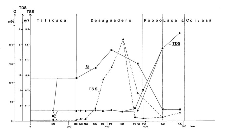 |
Fig. 11 Q/TSS/TDS Graph (Guyot, 1990) - click figure to enlarge.
|
Fig. 12 Q/TSS/TDS at exits of rivers, lakes, and salars.
6. SALAR FORMATION
|
|
The formation of the salares at Coipasa and Uyuni can be attributed to the following conditions: 1) Closed drainage basins (no natural outlet), 2) Natural sources of salts (Western Cordillera), 3) Arid climate (intense evaporation rates exceed precipitation), and 4) Cold weather (precipitation of salts due to "freezing out" in the winter).
The sources of the salts deposited in the salares include the following:
- Dissolution of evaporites from older geological strata (tertiary formations containing gypsum yield
Ca2+ and SO42-).
- Weathering of carbonate and silicate minerals in surficial strata (yielding HCO3-,
Ca2+, Na+, Mg2+, and
K+).
- Contribution of salts via volcanic events or thermal/saline springs (common in the foothills of the Western Cordillera;
solutes will depend on each individual spring source but includes Na+ and Cl-).
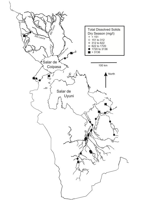
Salts from these sources will be transported down from the Western Cordillera by surface (e.g., snowmelt) and sub-surface runoff to the "alluvial plains" where they will accumulate in soils. Surface water salinity increases downstream toward the salares. Parameters such as alkalinity, chloride, sulfate, lithium, and boron also tend to increase downstream. Although the correlation between TDS and pH is not strong, there appears to be a weak increase in pH from the headwaters to the salares. Minerals from weathered rock via groundwater baseflow may contribute to the downstream increase in TDS, but it is the evapoconcentrative processes of surface waters with high salinity concentrations that contribute to the increase. Ultimately, the most soluble salts will arrive at the salares, to accumulate in evaporate crusts. These saline crusts are formed either as a result of annual flooding by surface water runoff from the surrounding regions (November to March) or as a result of an annually rising groundwater table within the salar itself. Average thickness of the crust is 2.5 m for Coipasa and 5.0 m for Uyuni (Fig. 13) (Bills, 2006; Banks, 2004).
|
Fig. 13 Surface Water System and TDS for Coipasa and Uyuni (Banks, 2004).
According to Banks (2004), the evaporate crusts in the centers of the salar areas are largely comprised of halite (sodium chloride), interlayered with thin laminae of silt and clay, although deposits of gypsum, lime, ulexite (sodium calcium borate: NaCaB5O9*H2O) and sodium sulfate (mirabilite and thenardite) are found around the salar margins. Other borates (such as borax and colemanite) and carbonates (such as trona and natron) are also recorded. Accumulation of evaporates is likely to have been episodic, related to the desiccation of successive lakes occupying the site (Lago Minchin 40,000 to 25,000 years BP; Lago Tauca 11,000 to 10,000 years BP). Studies were conducted using boreholes showed the presence of eleven evaporite beds down to 121 m depth beneath Salar de Uyuni. Lithium, boron, potassium-rich brines occur within the deposits of the salares (Banks, 2004).
A study was performed in the Lipez area, the very southern end of the Altiplano (about 150 km south of Uyuni), where salares are numerous but smaller in size compared to Coipasa and Uyuni. Temperatures range from -30o C in winter to 20 - 25o C in summer with annual averages varying 5 - 10o C. Annual precipitation rates decrease heading south from 150 to 50 mm, and evaporation rates vary from 1000 to 1500 mm per year. In other words, comparing the Lipez area with that of Coipasa and Uyuni, the former is generally the same in temperature, but drier and less severe in evaporation. Experts state that the salares of Lipez are formed by salts that mostly precipitate by "freezing-out" in winter (especially natron, mirabilite, and hydrohalite). Many lakes are frozen during a large part of the year, which reduces their rate of evaporation; however, the lower freezing point of the brines increases the time of "ice-free surface" exposure. The effects of aridity and low temperatures are evident. Soils and vegetation are sparse or completely lacking in the region. From this study one can deduce that during the winter season at the Coipasa and Uyuni regions, the "freezing out" of salts also play a key role in the formation of the salares (Risacher, 1990).
Another study on evaporation and land surface energy budget (albedo) was conducted at the Salar de Atacama in Northern Chile. The scientists agreed with Thorburn's concept that salt crusts have characteristics unique to those of most soils. Thorburn et al. (1992) examined a variety of existing data on evaporation from shallow water tables in bare soils and salt flats and found that for the same depth to groundwater, evaporation rates from salt crusts are lower than those from other bare soils. The attribution to this finding is due to reduced relative humidity gradients, restricted water vapor movement, high albedo, and low hydraulic conductivity of salt crust. Of these factors, the conclusion was that low hydraulic conductivity, perhaps caused by precipitation of salt in pores, is the likely factor that most decreases evaporation rates from salt crusts" (Kampfa, 2005). One can infer from Thorburn's thought process that if evaporation rates gradually decrease due to precipitation of salts in salt crust, "freezing out" of salts during winter most likely play a key factor in salt crust formation at Coipasa and Uyuni.
Bolivian salares can be classified morphologically into four types (Risacher, 1990):
Salt lakes consist of a permanent body of saline water lying on a low permeability substrate. The lakes can be shallow or deep and can dry up on occasion. In the Altiplano, salts mostly precipitate by "freezing out" in winter, especially natron, mirabilite, and hydrohalite.
Salt crusts are generally highly porous and partially filled with an interstitial brine. Such crusts which occupy the center of the basin are the result of the drying up of former saline lakes. Gypsum and halite are the dominant salts.
Playas occupy the central depression of a basin filled by lacustrine sediments. Interstitial brine reduced in concentration saturates a confined aquifer at depths varying from decimeters to meters. Commonly, a very shallow pool fed by shore springs may occupy a variable area of the surface. However, such a pool has no direct connection with the underlying brine and is often more dilute. Salts mainly precipitate within the sediment layers where solutions are drawn by capillary forces. The interstitial brine is exposed to the effects of evaporation and oxidation above the water table. Gypsum, mirabilite, and ulexite are commonly formed this way and may build up large, irregular lenses. Generally, playas do not show any vertical zonation.
Unconfined aquifers occur where the bottom of a basin is filled with coarse sediments such as sand or gravel. The water table stands at the topographic surface or just above, producing a very shallow, irregular shape pool or lake. Lacustrine sediments are not abundant enough to fill the center of the basin. Salts precipitate by "freezing out" and by direct evaporation.
Salares, especially the large ones (e.g. Coipasa and Uyuni) can consist of a combination of these types. Their morphology changes laterally from one type to the other. During the rainy season, salares may also show seasonal changes (Fig. 14) (Risacher, 1990).
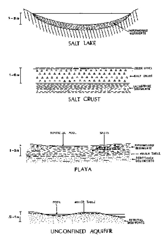
|
Fig. 14 Salar Morphology (Risacher, 1990).
7. SURFACE ALBEDO
|
|
Due to the salares high elevation, immense size, relative flatness, and homogenous surface (salt - white color), one must take into consideration the effect of high surface albedo and its impact on temperature, moisture, and climate in the region. Albedo is the ratio of the total shortwave (0.3 - 3.0) radiation flux, reflected by a given surface in all directions, to the total downwelling solar flux. The fraction of incoming solar radiation absorbed and not reflected goes to 1) warm the earth's surface (sensible heat), 2) power the evaporation process (latent heat), and 3) furnish the energy to sustain various biochemical processes (Ponce, 1997). After conducting a combination of measurements and model calculations, albedo was measured by an UV radiometer resulting in a reflectivity for erythermally effective radiation of 0.69 ± 0.02 which is extremely high (Reuder, 2006). For the purpose of comparison, albedo for fresh snow is 0.75 - 0.95, green grass is (0.26), black soil (moist) is 0.18, black soil (dry) is 0.14, and sea is 0.03 - 0.10 (Ponce, 1997).
Using a general circulation model (GCM), Sud and Molod (1988) have concluded that for arid and semiarid regions, the overall effect of high surface albedo is that of cooling inside the planetary boundary layer. This cooling induces sinking aloft and moisture divergence near the surface, both of which suppress moisture convection and rainfall. Thus, in a desert border region, an increase in surface albedo would be expected to reduce the convective rainfall locally (Ponce, 1997).
A desert is a landscape or region that receives almost no precipitation or an area where evaporation rates exceed precipitation rates. On average, deserts receive an annual precipitation of less than 250 mm per year. Both Salar de Coipasa and Uyuni have evaporation rates ranging from 1200 to 2200 mm per year and receive average annual precipitation rates of 240 mm and 190 mm per year, respectively. Hence, Salar de Coipasa and Uyuni are defined as deserts.
About 35,000 years ago, these salares were actual lakes, and through a natural hydrologic cycle of precipitation, evaporation, and evapotranspiration, these lakes eventually formed into salares because there was and still is no natural outlet to remove salts (endorheic system). With the passing of time, further accumulation of salts through dissolution, weathering, transport, and intense evaporation led to salares increase in size. Due to the white color of salts, high surface albedo has gradually impacted temperature, moisture, and climate of the region, transforming it to a desert which has the potential of becoming extremely desiccate due to the decrease in surface moisture (Fig. 15).
|
Fig. 15 Paleolakes (Wirrmann, 1995).
REFERENCES
|
|
Aquize, E. Lake Titikaka: The Highest Navigable Lake in the World.
Banks, C. 2004. Distribution, Salinity, and pH Dependence of Elements in Surface Waters of the Catchment Areas of the Salars of Coipasa and Uyuni, Bolivian Altiplano, Journal of Geochemical Exploration, No. 84, 141-166, July 1, Elsevier B. V.
Bills, B. G. 2007. MISR-Based Passive Optical Bathymetry from Orbit with Few-CM Level of Accuracy on the Salar de Uyuni, Bolivia, Remote Sensing of Environment, No. 107, 240-255, November 2, Elsevier Inc.
Guyot, J. L. 1989. Salinities and Sediment Transport in the Bolivian Highlands, Journal of Hydrology, No. 113, 147-162, April 15, Elsevier Science Publishers.
Kampfa, S. 2005. Evaporation and Land Surface Energy Budget at the Salar de Atacama, Northern Chile, Journal of Hydrology, Vol. 310, Issue 1-4, 236-252, January 4, Elsevier Science.
Moon, H. P. 1955. The Geology and Physiography of the Altiplano of Peru and Bolivia, Transactions of the Linnean Society of London: Third Series, Vol. 1, Issue 1, 27-43, The Linnean Society.
Pillco Zola, R. 2007. Three Methods for Determining the Area-Depth Relationship of Lake Poopó, a Large Shallow Lake in Bolivia, Lakes and Reservoirs: Research and Management, No. 12, 275-284, July 22, The Authors Journal Compilation, Blackwell Publishing Asia Pty Ltd.
Ponce, V. M. 1997. Surface Albedo and Water Resources: Hydroclimatological Impact of Human Activities, Journal of Hydrologic Engineering, Vol. 2, No. 4, 197-203, April 29, ASCE.
Reuder, J. 2006. Investigations on the Effect of High Surface Albedo on Erythemally Effective UV Irradiance: Results of a Campaign at the Salar de Uyuni, Bolivia, Journal of Photochemistry and Photography B: Biology, No. 87, 1-8, December 1, Elsevier B. V.
Revollo, M. M. Lake Titicaca: Experience and Lessons Learned Brief, 377-387.
Revollo, M. M. 2001. Management Issues in the Lake Titicaca and Lake Poopó System: Importance of Developing a Water Budget, Lakes and Reservoirs: Research and Management, No. 6, 225-229, April 27, Autoridad Autonoma Binacional Lago Titicaca.
Risacher, F. 1990. Geochemistry of Bolivian Salars, Lipez, Southern Altiplano: Origin of Solutes and Brine Evolution, Geochimica et. Cosmochimica Acta Vol. 55, 687-705, October 26, Pergamon Press plc.
Wirrmann, D. 1993. Late Quaternary Spatio-Temporal Limnological Variations in the Altiplano of Bolvia and Peru, Quaternary Research, No. 43, 344-354, June 21, University of Washington.
| http://altiplano.sdsu.edu |
|
170205 |