|
|
|
|
A methodology for the sustainable architecture of Arroyo Alamar, in Tijuana, Baja California, Mexico, is presented. Sustainable river architecture enables a seamless interaction between diverse stream functions and uses, including flood mitigation, groundwater replenishment, compliance with federal stream zoning regulations, preservation of riparian corridors, enhancement of water quality, and multipurpose land use such as agriculture, light industry, sports and recreation, and urban aesthetics. Topographic, hydrological, hydroecological, hydraulic, vegetation, and land-use data were assembled to accomplish the sustainable architectural design of Arroyo Alamar. In addition, a socioeconomic study was performed to develop the appropriate basis for design. The flood conveyance channel is designed to carry the 10-yr flood without restrictions and the 1000-yr flood with some restrictions. Above the 10-yr flood level, the 1000-yr flood plain is allocated to soft uses, including recreation. Users of these features would move out of harm's way in the event of an unusual flood. The floodway is stabilized using gabion systems and natural vegetation. The sustainable architectural design considers three parks in one: recreational, sports, and ecological. The 10-km reach of Arroyo Alamar is designed to reflect these uses. Sustainable river architecture successfully reconciles hydroecological laws and economic interests. It provides a clear societal benefit such as the inclusion of the river and its flood plain into the city's footprint. |
|
1. INTRODUCTION
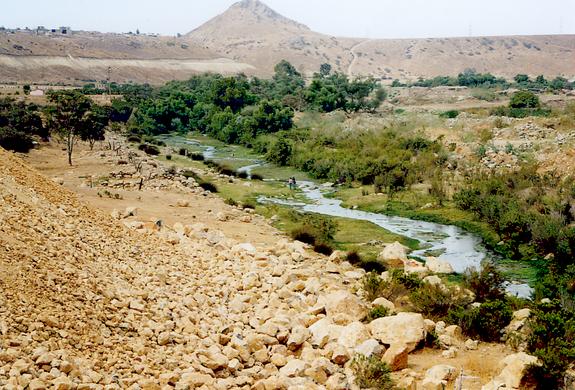
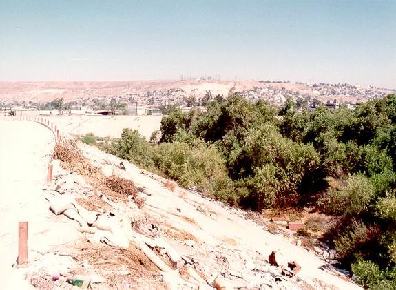
The Arroyo Alamar, in Tijuana, Baja California, is being considered by the Municipality of Tijuana for rehabilitation. The objective of the project is to enable a seamless interaction between diverse stream functions and uses, including flood mitigation, groundwater replenishment, compliance with federal stream zoning regulations, preservation of riparian corridors, enhancement of water quality, and multipurpose land use such as agriculture, light industry, sports and recreation, and urban aesthetics. The project encompasses a 10-km stretch of Arroyo Alamar, between Puente Cañon del Padre and its confluence with the Arroyo Las Palmas, in the city of Tijuana. Upstream of Arroyo Alamar, Cottonwood Creek and Tecate Creek join together in Marron Valley, just north of the U.S.-Mexico border, to form the Tijuana river. In turn, the Tijuana river takes the name of Arroyo Alamar as it enters Mexico and flows for about 5 km past Puente Cañon del Padre. Immediately downstream of the project site, Arroyo Alamar joins the Arroyo Las Palmas to again form the Tijuana river, which flows back into the United States and discharges into the Pacific Ocean at Imperial Beach, California. Due to its close proximity to the United States, the project site is of strategic binational importance. Over the past several years, lack of proper planning and disdain for regulation have produced an environment where irregular settlements abound, and where the unregulated stream uses, which include encroachment on the flood plain and illegal trash dumps, constitute a veritable flood risk and a public health hazard. Thus, there is an urgent need to rehabilitate the Arroyo Alamar, not only to restore its natural functions, but also to enable a planned and effective use of the stream to reduce the flood risk while maximizing the use of the flood plain. This leads to the concept of "sustainable river architecture," which refers to the design of the stream channel and its flood plain to conserve their natural functions, while at the same time recognizing their socioeconomic role and relationship to urban society. The term entails the design of the stream channel to convey the 10-yr flood without restriction (i.e., no artificial obstructions allowed), and the 1000-yr flow with some restrictions. The restrictions to the 1000-yr flood channel, perched above the 10-yr flood channel, allow only soft uses, where people can get out of harm's way in the event of a major flood, and where property damage would be minimal because only temporary and other ad-hoc structures would be allowed on the flood plain. While the concept of "sustainable river architecture" is decidedly novel, it has already been tried in several places with a great measure of success. To the writers' knowledge, the best example in Mexico of planned, mixed architectural use of a river and its flood plain is in Monterrey, Nuevo Leon, on the Santa Catarina river. In this project, a stretch of 7.5 km of river adjacent to downtown Monterrey has been recently rehabilitated following the principle of sustainable river architecture. The river and its flood plain have remained a visible and useful part of the city, while the flood control, groundwater replenishment, sports and recreation, and other sustainable development objectives have been properly addressed. |

|
|
2. RESEARCH OBJECTIVES
This project builds upon two previously funded Southwest Center for Environmental Research and Policy (SCERP) projects. The first project, funded in the year 2000-01, was titled "Flood hydrology of the Binational Cottowood Creek - Arroyo Alamar, California and Baja California." This project calculated flood discharges in Arroyo Alamar for return periods of 2 to 1000 years. A primary objective was to model event rainfall-runoff in the watershed of Arroyo Alamar, a binational watershed covering 1387 km2, 86% of which lies on the U.S. side of the border. Another was to use the routing model to estimate the volume of groundwater replenishment that would be lost to channel lining, which would satisfy only a flood control objective. The second project, funded in the year 2002-03, was titled: "Hydrecological characterization of Arroyo Alamar, Tijuana, Baja California, Mexico." The project characterized the Arroyo Alamar in terms of a host of hydroecological and socioeconomic functions, which included flood mitigation, groundwater replenishment, preservation of riparian corridors, compliance with federal stream zoning regulations, and multipurpose use of the flood plain. A primary objective was to design the channel cross section to convey the 10-yr flood in a lower portion and the 1000-yr flood in a much wider, upper portion. The U.S. Army Corps of Engineers' HEC-RAS model was used for this purpose. Other goals were to define horizontal and vertical alignments for the rehabilitated channel, within the perceived constraints of stream mechanics, hydroecology, hydrogeology, and socioeconomic use of the flood plain. Given the background of hydrological and hydroecological studies, the next logical step is to design the elements of sustainable architecture that are particularly suited to the Arroyo Alamar. The specific research objective encompasses the spatial design of the 10-km reach of Arroyo Alamar, seeking a compromise between the natural and anthropogenic functions of the stream. The natural functions include flood mitigation, groundwater replenishment, and preservation of the riparian corridor. The anthropogenic (i.e., socioeconomic) functions include the need for parks, areas for sports and recreation, landscaping, and aesthetics. In the framework of stream rehabilitation, the concept of sustainable architecture comprises the hydrological, ecological, architectural, and socioeconomic aspects that contribute to the spatial design of the stream and its flood plain. The ultimate goal is to design a channel that will foster an environment that floods, plants, animals, and humans can share with harmony, in accordance with the principle of sustainable development. |

|
|
3. RESEARCH METHODOLOGY / APPROACHES
The research methodology/approach consists of the following steps:
The project has collected topographic, hydrological, hydroecological, hydraulic, vegetation, socioeconomic and land-use data to accomplish the sustainable architectural design of Arroyo Alamar. The topographic data includes digital images of the project site. The hydrological data was collected as part of the project entitled "Flood hydrology of the Binational Cottonwood Creek - Arroyo Alamar, California, and Baja California." Flood discharges for the 2-, 5-, 10-, 25-, 50-, 100-, 200-, 500-, and 1000-yr return period were established in this study. (http://alamar.sdsu.edu/alamar/alamarenglish.html). The hydroecological data was collected as part of the project entitled "Hydroecological characterization of Arroyo Alamar, Tijuana, Baja California, Mexico." (http://ponce.sdsu.edu/alamar_hydroecology_final_report.html). The series of flood discharges was extended to 5000- and 10000-yr using the Gumbel method (Ponce, 1989). Using standard floodway design concepts, the 10000-yr design discharge is used to size the freeboard. In other words, the floodway should pass this flood peak using the available freeboard (The 10000-yr frequency is equivalent to the concept of Probable Maximum Flood, or PMF, in the United States). The project calculated design flood stages (hydraulic data) using the U.S. Army Corps of Engineers' Hydrologic Engineering Center River Analysis System (HEC-RAS) model. In addition to the flood stages, the hydroecological project defined the following objectives:
|
|
|
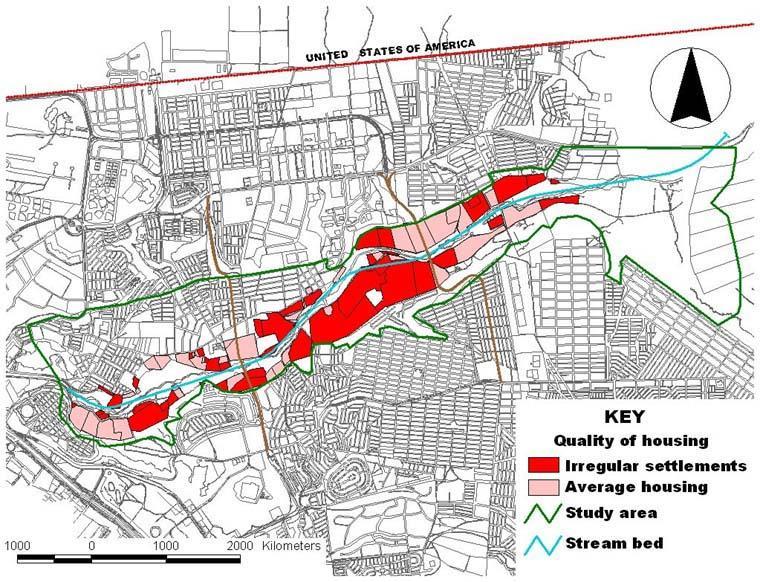
The GIS defines spatial management units. These units contain socioeconomic data, such as income, years of schooling, quality of housing, and characteristics of the infrastructure and environment. The latter will specify biological species, soil types, terrain slopes, and hydrologic information. The GIS makes possible the following:
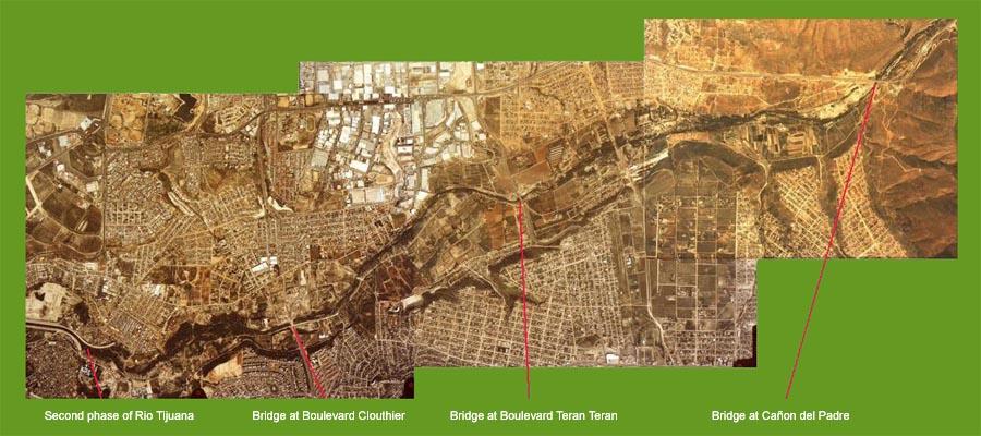
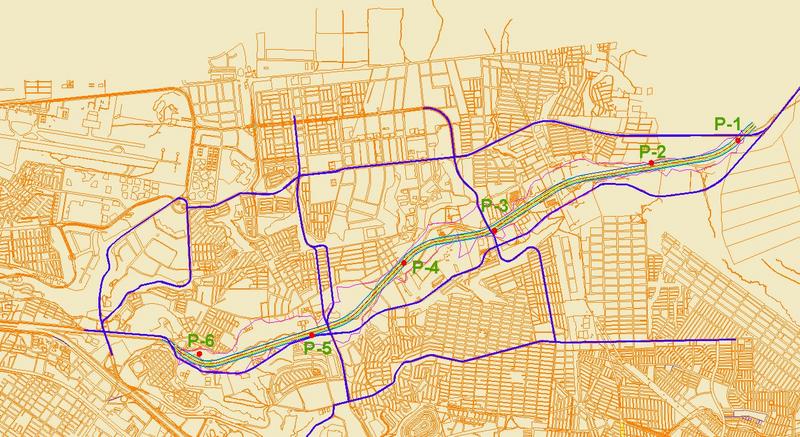
The design methodology encompasses the entire length of Arroyo Alamar, from its upstream end at the bridge at Cañon del Padre to its downstream end 10 km (actually, 9.88 km) downstream, to connect with the Second Phase of Rio Tijuana. This includes three distinct reaches (Fig. 4):
|
|
| Fig. 4 Aerial view of Arroyo Alamar, showing the limits of the three study reaches. |
|
The research methodology includes the review of several river rehabilitation projects that have been completed, particularly in Mexico. In the Atoyac river, in Oaxaca, the concept of river architecture, including groundwater replenishment, preservation of riparian vegetation, flood mitigation, landscaping, and recreation was successfully implemented in 1996. The Rio Santa Catarina and the Rio La Silla, in Monterrey, are two other successful projects of sustainable river architecture. Insights gained by the review of these projects is used in the formulation of the sustainable architectural design of Arroyo Alamar. |
|
4. PROBLEMS / ISSUES ENCOUNTERED
The research team encountered no major problems or issues during the period of performance. The project held monthly meetings in Tijuana, Mexico, to coordinate the work performed by the various members. Ana Elena Espinoza coordinated the work of the Tijuana staff. The field survey was contracted to INEGI staff in Tijuana. The project hired Ever Castro, a Tijuana architect, as an independent contractor to assist in the digital rendering of the architectural design. Data analysis and modeling was performed by Sezar Ercan. Web design and other web-based work was performed by Flor Perez. |
|
|
5. RESEARCH FINDINGS
The following three activities are summarized in this report:
|
|
5.1 Review of existing sustainable river architecture projects
The following projects were reviewed:
|
|
5.1.1 Rio Atoyac
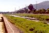
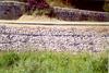
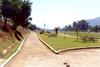
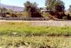
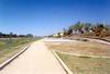
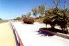
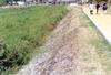
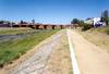
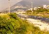
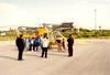
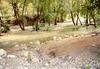
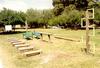
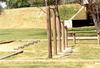
The Atoyac river, which crosses the city of Oaxaca, Mexico, was developed in 1996 following the principles of sustainable river architecture. A length of 2 km of river was channelized using a trapezoidal, eight-point cross section, and soft uses were implemented on the flood plain. These included walkways, exercise tracks, basketball courts, skating courts, playgrounds, and other recreational features. The pilot channel (10-yr floodway) was lined with gabions, and riparian vegetation was allowed to develop along the river banks. The most important accomplishment was that the river and its environs were effectively incorporated into the city's footprint, while the flood conveyance function was maintained and enhanced. A pictorial documentation is shown in Fig. 6.
|
|
5.1.2 Rio Santa Catarina
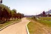
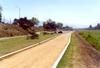
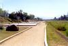
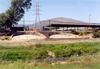
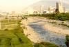
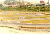
The Santa Catarina river, which crosses the city of Monterrey, Mexico, was recently developed (2002) following the principles of sustainable river architecture. The project developed 7.5 km of the principal watercourse, lying within the Monterrey city limits, into an ecological, cultural, sports, and entertainment park. The rehabilitation of the river environment and its incorporation into the urban footprint gives the city's population a safer, healthier, visually appealing, and more useful area. A pilot channel implemented as a floodway was designed to carry the 10-yr to 50-yr flood. Gabions were used to protect the banks of the pilot channel against erosion. The flood plain was built on the right side of the pilot channel, and designed to carry the 1000-yr flood. The plan for the park included facilities for sports such as soccer, basketball, volleyball, a go-kart track, and a temporary building for community entertainment. Flood plain areas are reserved for other temporary uses such as a swap meet and a helicopter pad. The economic viability of the project was assured with a series of marketing strategies. The external slopes of the channel were leased to advertisers. Flower garden arrangements with commercial motifs are planned on the high river banks (left margin). Cooperative agreements were signed with third parties to develop the flood plain for diverse cultural, sports, and recreational activities. The project has been documented in http://ponce.sdsu.edu/alamar_arquitectura_sustentable_santa_catarina.html. A pictorial documentation is shown in Fig. 7.
|


|
5.1.3 Rio La Silla
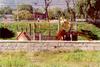
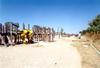
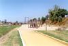
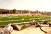
The project "Parque Natural Rio La Silla" encompasses a stretch of the Rio La Silla, located along the eastern slopes of the Sierra Madre Oriental, in the city of Monterrey, Nuevo Laredo, Mexico. The name "La Silla" originates in a nearby geologic outcrop that has the form of a chair (silla, in Spanish). This river crosses the city along a length of several kilometers, until it joins the Rio Santa Catarina. A 3-km reach of the Rio La Silla has been recently developed as a natural park (2002). The development includes fencing, various structures for sports and recreation, and a park administration building. The significant accomplishment has been the creation of another park within the confines of the city of Monterrey. The park is being used by the local population as a natural environment, thus the name of "Rio La Silla Natural Park." Several recreational activities are permissible, all-the-while actively promoting a culture of environmental stewardship of the park's natural resources. The park has a high biodiversity, with the presence of diverse species such as fish, squirrels, woodpeckers, turtles, sycamores, and ancient sabinos. Sports and recreation features include exercise facilities and a walking fitness course and bicyle path. The project has been documented in http://ponce.sdsu.edu/alamar_arquitectura_sustentable_santa_catarina.html. A pictorial documentation is shown in Fig. 8.
|

|
5.2 Basis for sustainable architectural design of Arroyo Alamar
A socioeconomic study was performed with the objective of developing the basis for the sustainable architectural design of Arroyo Alamar. The report can be found at the following web address: Arquitectura Fluvial Sustentable en el Arroyo Alamar, Tijuana, Baja California, Mexico." The report considers the following topics:
|
|
|
The conclusions of the report are the following:
|
|
|
5.3 Sustainable architectural design of Arroyo Alamar
This section consists of six subsections:
|
|
5.3.1 Design philosophy
Rivers are natural entities possessing physical, chemical, and biological properties. They use the force of gravity to convey water, which carries solids (suspended and dissolved, consisting of sediments, humus, nutrients, and other chemical constituents) from uplands to the sea, closing the hydrologic cycle. In addition, they serve an anthropogenic purpose, conveying water to rural and urban settings, where it is used to satisfy various needs. Rivers perform a host of natural functions, among which some of the most important are:
In this era of environmental awareness, urban societies can no longer afford to treat rivers only as flood-conveyance systems. Equally important are the other functions identified above. Thus, sustainable river architectural design entails a multidisciplinary approach, wherein specific attention is paid to the river's natural functions, together with other identified anthropogenic functions. In the case of Arroyo Alamar, in addition to serving the aforementioned functions, the river has to serve a land-use purpose, which includes agriculture, light industry, and sports and recreation. Thus, the sustainable architectural design of Arroyo Alamar hinges upon the formulation of the natural and anthropogenic functions of the river to enable a seamless interaction of diverse uses, in the spatial and temporal domains. In essence, it means the design of a flood conveyance channel that can carry the 10-yr flood without restrictions and the 1000-yr flood with restrictions. It implies that above the 10-yr flood level, the 1000-yr flood plain can be allocated to soft uses such as sports and recreation. Users of these features would move out of harm's way in the event of an unusual flood. To satisfy the perceived need for groundwater replenishment, the 10-yr floodway should be stabilized using natural or some other soft means. Gabion systems are particularly indicated for permeable-surface river bank stabilization (Ponce et al, 2003). A significant feature of the sustainable river architectural design for Arroyo Alamar is the incorporation of the river and its environs into the city's footprint. This feature provides a host of social and other related benefits that set this solution apart from outdated channel-lining solutions which ostensibly sequester the river from the city. Natural rivers are aesthetically pleasing live entities. Therefore, the sustainable architectural design must preserve and enhance these natural characteristics. The design philosophy for sustainable architectural design is in line with recent experiences in the Atoyac river (Fig. 11), and the Santa Catarina and La Silla rivers, as documented elsewhere in this report. The common denominator for these projects is the maintenance of natural functions and the effective incorporation of the river and its environs into the city's footprint. Thus, the same design approach is postulated for the Arroyo Alamar. |
|
|
5.3.2 Horizontal alignment
The design of the horizontal alignment of Arroyo Alamar has been accomplished using the current location of the streambed. It is understood that the stream will have a tendency to change its alignment with time. The proposed alignment fixes the streambed in order to define the external limits of the project. The details of the horizontal alignment are given in Section 5.5 of http://ponce.sdsu.edu/alamar_hydroecology_final_report.html. |
|
5.3.3 Vertical alignment
There are three ways to design the vertical alignment of a river channel.
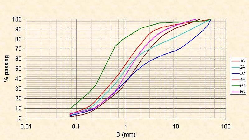
The second solution, the "cut and fill" type, is environmentally appropriate, but it requires a large footprint in order to provide reasonable flood control (100-yr or larger design flood). The third solution, a "depressed channel" type, is a convenient compromise between competing hydroecological laws, anthropogenic uses, and economic interests. In the case of Arroyo Alamar, the depressed channel solution makes sense, particularly because the extracted material (sand and gravel) could be commercialized to help finance the park project. Commercial sand and gravel are at a premium in California and Baja California, with large volumes being annually exported from Baja California to California to satisfy the demand. A report on this subject can be found at http://threeissues.sdsu.edu/three_issues_sand_mining_facts0.html. In addition to making economic sense in the region, the "depressed channel" solution makes sense from an aesthetic point of view. Both the Atoyac and Santa Catarina rivers have "depressed channel" solutions, and the landscaping and aesthetic benefits are shown to be quite significant. This same type of solution has been tried in the Tercera Etapa of Rio Tijuana, albeit with concrete lining of the floodway. From a hydrological and architectural standpoint, the "depressed channel" is the preferred solution for the vertical alignment of Arroyo Alamar. To examine the quality of sand and gravel, six exploratory boreholes were dug in the project site. The details of the sampling are given in http://ponce.sdsu.edu/alamar_sustainable_architecture_grainsize_analysis.html". Figure 12 shows the location of the boreholes, and Fig. 13 shows the results of grainsize analysis. Five samples (1C, 2A, 3C, 4A and 6C) classify as either SP (poorly graded sand) or SW (well graded sand), and only one sample (5C) classifies as SP-SM (silty sand). For the most part, the bed material of Arroyo Alamar is composed of coarse alluvial material in the sand and gravel sizes, competent to be used as construction materials. Preliminary estimates of the quantities of removed material for several postulated vertical alignments are found in http://ponce.sdsu.edu/alamar_hydroecology_final_report.html. The final choice of vertical alignment will require more detailed study and analysis, including detailed topographic maps. |
|
|
|
5.3.4 Hydraulic modeling with HEC-RAS
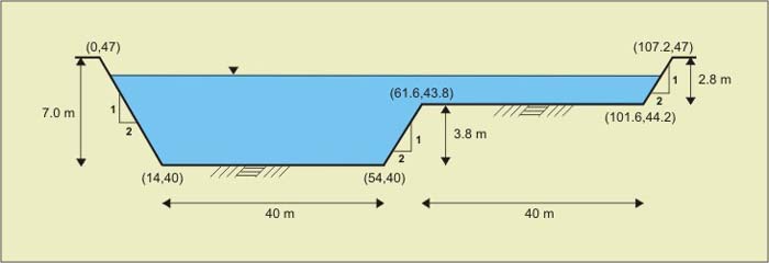
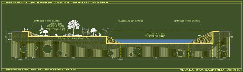
The design flood discharges for Arroyo Alamar have been calculated by Ponce (2001). These flood discharges are used to calculate flood stages in the typical cross section, using the U.S. Army Corps of Engineers' HEC-RAS model. Details of this modeling are given in http://ponce.sdsu.edu/alamar_sustainable_architecture_hecras_six_point_run.html. Table 1 shows the hydraulic data, including discharge, flow depth, inbank flow mean velocity, overbank flow mean velocity, inbank Froude number, total Froude number, and freeboard. It is seen that the designed cross section is able to pass the 10000-yr flood peak, which is akin to the concept of Probable Maximum Flood (PMF). The freeboard for the design 1000-yr flood is 1.02 m, and for the 10000-yr flood (the "freeboard hydrograph") is 0.1 m. Figure 14 shows the typical cross section in the sustainable architecture design of Arroyo Alamar. |
| Table 1. Hydraulic data for Arroyo Alamar calculated using HEC-RAS model. | |||||||
| Return period (yr) |
Discharge (m3/s) |
Flow depth (m) | Inbank flow mean velocity (m/s) | Overbank flow mean velocity (m/s) | Froude number (inbank) | Froude number (total) | Freeboard (m) |
| 10 | 680 | 3.70 | 3.87 | - | 0.69 | 0.69 | 0.10 |
| 50 | 1140 | 4.87 | 4.62 | 0.76 | 0.72 | 0.79 | 2.13 |
| 100 | 1310 | 5.22 | 4.84 | 0.95 | 0.73 | 0.76 | 1.78 |
| 500 | 1600 | 5.77 | 5.16 | 1.20 | 0.74 | 0.73 | 1.23 |
| 1000 | 1720 | 5.98 | 5.28 | 1.29 | 0.74 | 0.73 | 1.02 |
| 5000 | 2140 | 6.67 | 5.65 | 1.55 | 0.76 | 0.71 | 0.33 |
| 10000 | 2290 | 6.90 | 5.77 | 1.64 | 0.76 | 0.71 | 0.10 |
|
|
5.3.5 Sustainable architectural design
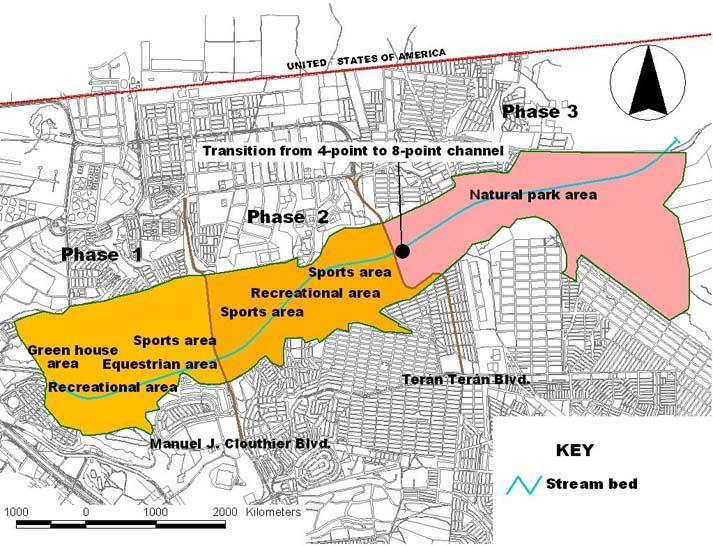
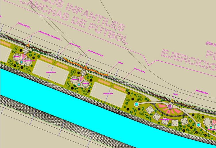
Based on the socioeconomic study, the sustainable architectural design of Arroyo Alamar was divided into three phases as follows (see Fig 10):
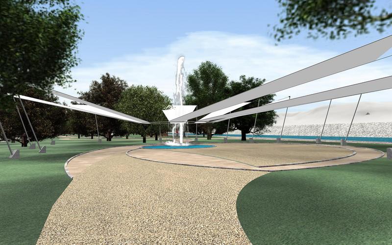
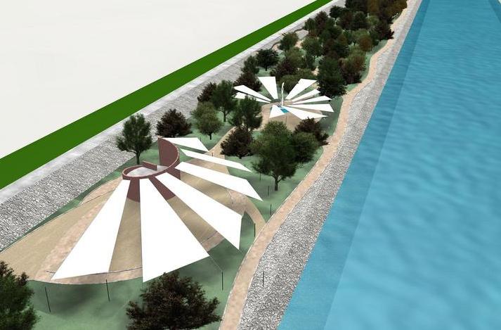
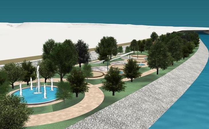
The sustainable architectural design of Arroyo Alamar is shown in Table 2. This table includes the visualization in jpg format, mobile design, perspectives, virtual camera, and movies. A sample of the design in shown in Fig. 15. A sample of the digital architectural rendering (see "Perspectives" in Table 2) in shown in Fig. 16. |
|
|
|
5.3.6 Implementation
The implementation of a design such as the sustainable architecture of Arroyo Alamar requires a good measure of political will and strong and dedicated leadership. For one thing, there is the issue of where to relocate the current settlers of the flood plain. Areas currently occupied by irregular settlements will have to be cleared to make way for the park project. This will require an organization of stakeholders and government officials committed to seeing the project to completion, despite the odds. Of course, the alternative is to do nothing, but this is unsustainable and bound to make matters worse in the future. In the case of the Arroyo Alamar, the issues of public health and flood risk should be taken seriously. One way to facilitate the implementation of the project, which has been tried in other places, is to bring in commercial third parties that would be willing to develop the flood plain with temporary uses. This course of action has been used successfully in the Santa Catarina project, where entertainment services companies have been brought in to collaborate with the city in the development of the flood plain. It is also possible to lease space along the river banks to commercial companies for flower gardens and other landscaping projects that advertise established brands. Any of a number of economic incentives can be tried to interest third parties in the flood plain development with soft uses. In this way, everybody wins, and the project can be carried to the implementation stage. The examples reviewed, Atoyac, Santa Catarina, and La Silla rivers, show that the sustainable architecture alternative for flood plain development makes hydrological, ecological, economic, and social sense. It is the only holistic way of dealing with flood plain development in urban settings. |
|
6. CONCLUSIONS
The following conclusions are obtained from this study:
|
|
|
7. RECOMMENDATIONS FOR FURTHER RESEARCH
The following recommendations are offered for further research:
|
|
|
8. RESEARCH BENEFITS
The following research benefits have been identified:
|
|
|
9. ACKNOWLEDGMENTS
The authors wish to acknowledge the assistance of the following persons:
|
|
10. REFERENCES
|
|
| 041223 |